|
If someone deletes an item, I realise I don't know how I can find the original data (or who changed it, or why, or the history) unless I know the id. (Obviously, if I have an old copy of the data, then I have the id, but in the case I just hit, I didn't). Is there some magic way I don't know about, despite my many years with OSM? Is there some way to ask for deleted items in a bounding box? |
|
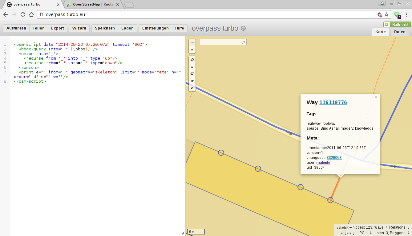
When you know where data is amiss you can use use Overpass Turbo to display the data of that region at a certain date or between two dates. To do so you go to the place where you miss the data (zoom in as far as possible to minimize the server load), paste the query of your desire at the left side and click "Run". To restore data you can either click on the data you look for and use the changeset or way/node ID for an undeletion in JOSM with reverter or undelete plugin. Or you try some of the possibilities "export" offers (although only "raw data" worked for me while testing it now. (I tried to paste the queries here but they aren't shown, thus just the link.)
Your query give me an error An error occured during the execution of the overpass query! This is what overpass API returned: Error: line 5: parse error: ';' expected - 'osm' found. Error: line 12: parse error: Unexpected end of input.
(01 Dec '16, 15:06)
ff5722
|
|
If you forget both the location and id, there's still a tedious way. Download the full-history file and search for the item with your item's name (or any tags). If the item has the condition of "visible=false", then it's deleted. But remember, this is the last resort. |
|
You can use Potlatch 1 to look for deleted ways in an area. There isn't an easy way of looking for deleted nodes. If someone's deleted something and replaced it with something else then you can of course look for nodes that were deleted in the changeset that added the new thing, but with large changesets that'll be a challenge. Yes, it was nodes I was after this time. Useful to know about ways in old Potlatch though. How does it do it, if there isn't an API call for it? Perhaps we need such an API operation?
(07 Jul '16, 15:43)
davidearl
3
Potlatch 1 uses its own API. The call has never been recreated in the mainstream XML API.
(07 Jul '16, 21:49)
Richard ♦
|
|
The answer that is now at the top guided me in the right direction when I now had this problem (was wondering why there was no building on the map where I remember one being in reality), but may be confusing to some people; it certainly was for me. Overpass Turbo is indeed the right tool for this job. A query that finds historical data there looks something like this: Adjust the date in the When you have found a date when it still existed, it will display the deleted object on the map, which you can click and will get a link to an ordinary openstreetmap.org/way/... link which you can click and find the changeset that deleted it. |
quite the same question as https://help.openstreetmap.org/questions/23631/how-do-i-find-and-recover-a-deleted-way , isn't it?
A little outdated mentioning tools which don't exist anymore and not mentioning all existing working ones.
@malenki: then update it! ;-) People will still find the old question.