|
The wiki entry for farm suggests that the main farm buildings should be tagged with
However I see that there is a Experimenting shows that Mapnik does not render |
|
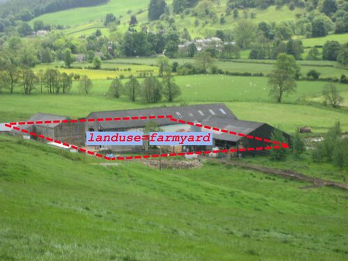
Use landuse=farmyard with a polygon around the general area of the clutch of buildings making up a farm. You might then also do a few building=yes polygons for individual buildings if you have a way of mapping those accurately. That's pretty similar to how we map several buildings making up a school or a hospital. place=farm is confusing (and I must say I disagreed with its addition in the first place) but it's part of the family of tags on Key:place which are for naming an area. So for example an area is known by the locals as "Upperknowle Farm". In fact there doesn't necessarily need to be an active farm there, or any buildings whatsoever. These can be labels for bits of moorland traced from old out of copyright maps for example, and maybe that's the best time to use it. If you have an active visible farm with a particular name, I'd say it's better to tag it landuse=farmyard, name=x ...and forget about the place tag. Yeah, from my experimenting I'd have to agree. Thanks Harry.
(03 Aug '10, 10:29)
GrahamS
|
|
If I understand that wiki page correctly The OS OpenData in the UK usually has farm names on it and it is very common for these to be used as the farm address. But if I tag a node place=farm AND mark the area as landuse=farmyward, and give them both names, then they will both be rendered in Osmarender which doesn't look right.
(30 Jul '10, 11:15)
GrahamS
I actually thought to tag the area with both and not add an additional node.
(30 Jul '10, 11:38)
RoToRa
Okay I've just tried tagging the same area with place=farm and landuse=farmyard. That looks okay in Mapnik, but in Osmarender it renders the name twice. Once in large black text and again in smaller blue text, with the blue text rendered directly on top of the black.
(30 Jul '10, 12:18)
GrahamS
|