Why does JOSM warn me that uploading my GPS traces to OSM is "considered harmful"? I found a road that isn't on OSM, so I turned-on my phone's tracer and walked the length of the road, recording nodes every 5 seconds. At the end of the road, I saved the trace to a GPX file. I transferred the GPX file to my computer, opened it in JOSM, right-clicked on it, and left-clicked on the "Convert to data layer" button. I then got a popup that said
Unfortunately, the link didn't have any additional information on why this is harmful. Why is it harmful for me to add my GPX data to OSM? What am I supposed to do to add a new road? asked 11 Aug '23, 17:25 maltfield edited 11 Aug '23, 17:26 |
4 Answers:
GPS traces often have a lot of noise in them and are limited in their accuracy. GPS traces should normally be manually redrawn to remove a lot of this "jitter". An ideal scenario would be to record multiple tracks over multiple days to try to "average out" any transient errors, but that is rarely practical as a starting point and a trace or two is normally all that is used at the start. answered 11 Aug '23, 17:54 InsertUser To remove gps jitter in JOSM is fairly simple with the use of simplify way function. For gpx representing roads, you can set to 1 mtr threshold and still get very nice 'smooth' looking final track that you can trace/import and improve. (13 Aug '23, 13:03) kucai |
Hi. Basically you can use your GPS trace has an overlay, to have an idea where the road is. You can even upload it in a dedicated database so that it will be available for anyone (the link you checked). But to map a road, you want to create as few nodes as possible, connect with crossing roads, and so on, add relevant tags, which will not be easy if you import the GPS trace. Not impossible to clean up, but a lot of work for not much. You may also want to activate a satellite imagery layer, and check if others have uploaded GPX tracks in the vicinity, it's the only way to know if your GPS unit is more or less accurate. Hope this helps. Regards. answered 11 Aug '23, 18:07 H_mlet The satellite imagery just shows a cloud (11 Aug '23, 18:09) maltfield Well, that's annoying. Did you check all the imageries available in JOSM ? Unfortunately most are from the same provider and have the same clouds... :-( The best in this case would be to record GPS trace until out of the cloud, if possible. And as InsertUser said, make a few passes, in each direction. My phone's GPS can easily be 100 meters off, usually in one consistent direction. Handheld GPS devices have usually better results, depending on the context (trees, buildings, etc.). A lot of work for a single road you may think. Otherwise, just map the road as best as you can, with the help of your GPS trace, from memory (was there any bend here?), and tag a fixme on it describing the things to be corrected or as many others do add note=approximate. OSM is always a work in progress, when imagery will be available, you or others can improve the geometry of the road. Another technique I found useful, was to map on the spot. Under the cover of trees, I mapped paths using Vespucci, stopping at every bend, trying to get my bearings, and so on. Quite long but rewarding in the end. Best regards. (11 Aug '23, 18:32) H_mlet If the clouds appear on the Mapbox layer then they have a tool to request a refresh. IIRC this is only used as input when they make their usual purchases though so the wait is significant. If you see sky from the road you might get lucky with Sentinel 2 imagery. The resolution isn't great but it gets updated frequently. (12 Aug '23, 10:21) InsertUser I couldn't find Sentinel 2 imagery. I looked in the JOSM and Potlatch3 options (17 Aug '23, 10:36) andy mackey |
note that the alert says, as you quote it:
the part which is harmful is contained in the two above highlighted sections.
uploading GPS traces is a good thing, if you upload them as GPS data, as traces, preferably with visibility that allows timestamps to be available. uploading the same information as map data is a bad idea, because you're begging other mappers to clean up all more or less random errors contained in the points grabbed by your GPS device. answered 12 Aug '23, 13:38 mariotomo |
I have uploaded many miles of traces of walks usually recorded with a Garmin at shoulder height and traces have been useful. Moto android phone traces are good as well. If we upload traces as public even with the odd rogue point they can still be used to align The Bing ( or other) images. I'll map stuff from best images available, but ideally only after averaging and aligning the images against all available traces. answered 16 Aug '23, 20:48 andy mackey edited 17 Aug '23, 10:13 1
(16 Aug '23, 23:49) InsertUser |
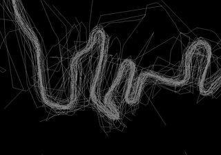 You can get a decent approximation with enough repetition.
I've voted this question down because (as the message actually says) JOSM is not warning that "uploading GPS traces to OSM is considered harmful".
Note: This question was migrated to the OSM Discourse here https://community.openstreetmap.org/t/why-is-uploading-gps-traces-considered-harmful/109718