|
I have cut the area border to a residential area by mistake, changeset 118117608 or possibly 118108171 and I would like to join up the gap but can't as the join is behaving like a line and not an area border |
|
Yes, it does make sense, thank you. Hi BC So glad to say everything looks ok this morning. Thank you so much for your perseverence in helping me. I have learnt a lot about areas and the way the borders of them work. I have given you max points of 11. You deserve more!!
(07 Mar '22, 09:39)
helen
|
|
Yes, of course. I do not agree that the residential area as shown in tinyurl.com/mvb6yn99 is ok now. It looked perfect in the link but it does not look perfect on osm as shown by the jpeg I attached above. Thanks OK, your jpeg is highlighting a selected member of the multipolygon in the iD editor, namely Way: 262219471 which is only one of the six members/sections that make up the multipolygon relation. If you look again at the link (https://tinyurl.com/mvb6yn99) you'll see listed to the left side all six members of the multipolygon. In that list if you click on the member Way: 262219471 you'll be shown that member. Click the other ways to see them. Altogether the six members make up the multipolygon. Does that make sense?
(06 Mar '22, 19:07)
BCNorwich
|
|
Hello, Sorry but it is not working ok now. The wedge shaped residential area is over the top of the original residential area that I damaged and thus the original residential area does not show up on oomap which renders at 8.00 am , I believe. I sent the jpeg of the area to show how the area border is not joined up just left of the centre of the map. I cannot join the gap as I do not have the skills but the wedge shaped area is not behaving like an area either. I suppose this is because it is over the top of the original area. Sorry I have tried to explain myself as clearly as possible but seem to have failed, maybe due to lack of familiarity with the website. The attached shows what the residential area looked like on oomap before I made the mistake. Sorry, it won't upload as I don't yet have 60 reputation points!! Would it be possible to reverse the changesets until the residential area is whole again , even if that means losing work? Thanks Can we sort one thing at a time please, it might help us. You said above that "The multipolygon highlighted in red is the area in question and it looks great.", Would you still agree that the residential area as shown here:- https://tinyurl.com/mvb6yn99 is OK?
(06 Mar '22, 18:21)
BCNorwich
|
|
Hi BC The multipolygon highlighted in red is the area in question and it looks great. I can only imagine I made my mistake after this changeset.I am attaching a jpeg of how oomap.co.uk looked at 10.30 this morning. It shows the wedge shaped area I added after I realised that the correct residential area had disappeared. As you can see it does not follow the outline of the correct residential area which I was trying to tweak. I am sorry for not paying better attention and not realising I had made a mistake straight away, Thank you Helen
Glad it's OK now. A point to realise is that an edit to the OSM database is effected immediately the changeset is uploaded. The open orienteering map would take some time to be updated and re-rendered from the OSM database. I've just Googled and it looks like open orienteering map is updated daily so we were lucky to see it re-rendered so quickly.
(06 Mar '22, 17:11)
BCNorwich
|
|
Attached is a jpeg of the problem area, taken today Thanks helen |
 showing how the area border is no longer joined
|
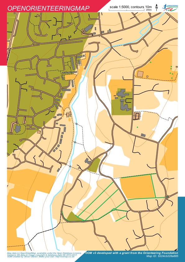
Hi BC Norwich Thank you for looking at my map work. It is quite a messy area and difficult to see what is going on. However with reference to open orienteering map, whereas the whole of the area previously had residential areas to the west and east of the stream now there is only a residential area to the west of the stream. I only started on OSM last week and I am afraid I cannot see how you are giving numbers to ways. All I can say is there seems to be a break in the residential area border to the east of the stream with a non joined residential area border to the west of the Bursledon Junior school and east of stream. This means that the eastern area of map is not showing as residential area( with some open area here and there)It actually looks like the new residential area I added is showing as a wedge shape in the west of stream but the previous residential area I cut by mistake has disappeared. I think my changeset 118117608 or 118108171 are the culprit, Thanks very much helen Hi, The residential area, multipolygon Relation 3520743, does show the area to be both east and west a stream. Please see here:- https://tinyurl.com/mvb6yn99 for the multipolygon highlighted in red. (I think/hope we're talking about the same one.) I looked at the open orienteering map and if the white area is all residential it is both east and west of the stream:- https://tinyurl.com/2p8k5wx4
(06 Mar '22, 13:49)
BCNorwich
|
|
Hi, Your new residential area Way: 1037293658 Changeset #118134630 was drawn inside of an existing multipolygon residential area, I've removed it. There was a break in the outline of multipolygon Relation 3520743 (between Way: 262219471 and Way: 1037218923), which I've repaired. It looks OK to me now could you please check? |