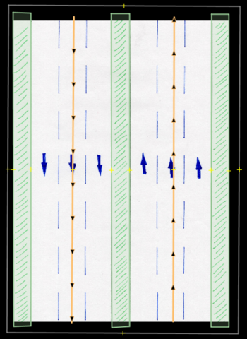
Ciclovía is a concept created in Bogotá, Colombia in the 80s, where normal streets are blocked for cars to only allow bikes and people to go there. This happens only on Sundays mornings. In order to allow reduced traffic, there are detours, shared highways (dedicated lanes), etc. We have created a project to map all of these, initially in Bogota; but this same thing happens in all other cities where ciclovía (open streets) is being used. This is the wiki documentation of the project. As part of the project, we identified several restrictions and detours cases. Here is the issue of case 4. This is the normal behavior of the highway:
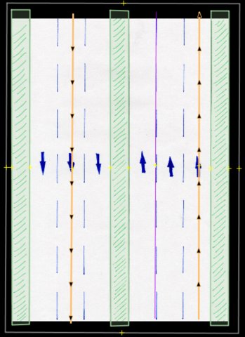
This is how it looks during ciclovía (I drew the ciclovía as cycleway just for the image):
As you can see, the right highway has 3 lanes, with 2 of them for ciclovía and 1 still for cars. How can we map all these conditions?
This is a JOSM file to play with the highway and propose a solution. asked 04 Feb '22, 18:38 AngocA edited 09 Feb '22, 18:31 |
One Answer:
The street stays a highway type regardless of time, e.g.
This works on the street above with separate carriageways for the two directions. If you have two-directional streets you need to add You could also add a description to make the concept of Ciclovía known: This answer is marked "community wiki". answered 05 Feb '22, 18:39 TZorn edited 07 Feb '22, 11:19 |
Thank you for your answer, however the JOSM Validator is showing a warning: "Wrong syntax in bicycle:lanes:conditional", the same for foot:lanes:conditional as well as oneway:lanes:conditional. Does it mean this suffix combination is something "new" or not supported by the map?
It is a pretty uncommon suffix combination but it has been used before (taginfo). I guess JOSM is not able to parse it properly.