These are designated areas where cross-country (i.e. off trail) access by motorcycles is permitted. I searched OSM wiki, forums, and help and didn't see anything specific to this topic. I'd be happy to have a reference to exiting documentation if there is some. My first guess was to use an area with leisure=park and motorcycle=yes, but is there a better way to indicate the nature of these areas? asked 01 Nov '21, 15:06 b1tw153 |
3 Answers:
Please don't use
I've had a quick look for 4 wheel drive off-road experience locations in the UK (such as these), but although they are quite common, they appear to be unmapped. I note that a related driving activity skid pans do not appear to be mapped much (2 that I can find). Obviously a shortage of real petrolheads in OSM (I once worked for a small firm where I was the only person without this obsession : company days were 4wd off-road, karting & the firm sponsored a colleague who raced homologated Honda ....) answered 01 Nov '21, 17:38 SK53 ♦ |
I don't think leisure=park fits. If motorcycles can freely use any part of the area (not just specific ways), that seems to rule out "typical" park-like activities such as strolling around enjoying the fresh air. An access tag such as motorcycle=yes shouldn't be used to completely change the meaning of the main tag. It sounds more like a dedicated sports facility than a park. Is it similar to https://wiki.openstreetmap.org/wiki/Tag:sport%3Dmotocross ? An example might help (e.g. a location where we can see background imagery, or the website of such a facility). answered 01 Nov '21, 17:16 alan_gr |
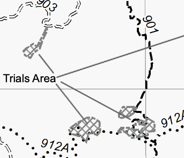
Thanks for the quick replies. I'm happy to change the tags to something more appropriate than leisure=park if it's clear what the tags should be. Maybe an example will help. The areas in question are designated in the Cleveland National Forest Motor Vehicle Use Map. Here's how the map depicts these areas.
The USFS map legend makes it clear that the Trials Areas are for motorcycle use only even though some trails (e.g. 901) are also option to ATVs, and other trails (e.g. 903) are open to any street-legal motor vehicle. Here's a link to one of the areas off the 912A route: Trials Area. If you look at the aerial imagery, you can see that this is not a motocross track. It's just a rock outcropping that has been designated as an open riding area. For reference, motorcycle trials is a distinct sport from motocross. So I wouldn't think that leisure=track or sport=motocross would be appropriate here. answered 01 Nov '21, 19:00 b1tw153 |
I suspected as much, but wanted to cover the principal bases. I believe BMX riders have similar areas, and as I pointed out off road 4wd vehicles too, so a generic off-road terrain area tag for leisure would work. Another analogy is leisure=skatepark. A last option which would be visualised, but which I personally dont like, is leisure=sports_centre + a sport tag. Given the wikipedia entry motorcycle_trials may be OK for the latter, but does not yet exist. The tagging mailing list is the usual place for further discussion at this point.