In my area of mapping (Thailand), I see a lot of inconsistencies in the classification of minor roads and I am looking for some feedback on best practices and hopefully some definitive answers. (Country wiki provides no guidelines) I will not provide real-world examples since my goal is not to fix specific OSM data, but to come up with a set of rules and guidelines. If the theoretical examples are not clear enough, please let me know in the comment section what other information you need. How should these minor roads be classified?
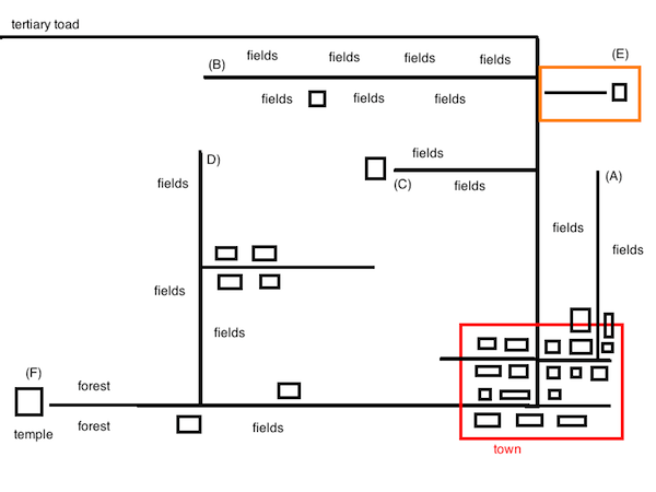
A) a minor road within a settlement has a few houses at the beginning but the rest of the road has only agricultural fields on each side. B) a minor road has mostly agricultural fields on each side but there could be 1 or 2 rare houses along. Should the road be tagged entirely as residential or track? Does a single house in a middle of a long minor road justify a residential classification? C) a minor road ends at a private house but on the way, there are mostly agricultural fields on each side that look like belonging to different owners (so not a driveway). D) a minor road has agricultural fields on each side but in the middle, there is a small residential road branching out with a couple of houses. E) a road inside a private agricultural field leads to some hut. F) a minor road ends at a temple, along the way, there could be on each side agricultural fields, a permanent residence, and some public forests. Should the road be tagged as unclassified, service, residential, track...? Excerpts from the OSM wiki: highway=unclassified
highway=residential
highway=service
highway=track
asked 30 Jul '21, 07:35 cmoffroad edited 31 Jul '21, 16:26 showing 5 of 16 show 11 more comments |
One Answer:
I decided not to listen to those who said it's too complicated to come up with some rules and instead came up with clear guidelines using decision trees instead of single definitions. It has been reviewed by some of my country community members, and while it may be subject to minor changes, it covers at the moment most scenarios. https://github.com/cmoffroad/osm-guidelines/ Happy Mapping! answered 08 Aug '21, 06:29 cmoffroad Cheers. Look nice! I'm a little concerned about a track definition, "is the road unpaved and giving access to forestry/agricultural fields?" because some of the track (tracktype=grade1) is paved. Anyway, to avoid going into too much information for a quick decision, it's fine to leave this out because more than 99% of the track is unpaved. (08 Aug '21, 13:22) nitinatsangsit |
How about some links and the name of the country ?
These are common road scenarios so I will not provide links. If the descriptions are not clear enough, please let me know. Country is Thailand. My goal is not to fix specific links/roads, but to gather best practices and come up with guidelines.
Without more information, the answer is "it depends".
@SomeoneElse what other information do you need? The use-cases should be concise enough to give readers a clear visual. If not, please let me what is confusing.
I do not want to share links of real roads, because guidelines should be based on rules and not on case by case basis.
When you say "access to farms", what are you referring to? Is it that you can access a farmhouse/farmyard from it? Does it only provide access to the farm fields? Is it running through the fields? What does the construction of the road look like? Paved, dirt, two-track through grass? Does the construction change at any of the intersections you mentioned? Without seeing examples, it's hard for us to give you any suggestions because there are so many other variables beyond what you've already provided.
That's one view, but traditionally OSM tagging has evolved rather than being codified before anyone started mapping anything. For example, I live on a road that is used for residential access to houses (highway=residential), but also for access to fields and farms (highway=track, but it's not part of the public road network so maybe even highway=service; service=driveway)? Any small change to the circumstances changes the balance, and might point to one tag being a better option than another.
Maybe also see https://wiki.openstreetmap.org/wiki/Duck_tagging
@alester thanks for the feedback! I will improve the wording and provide some drawings to make it clearer. Reg. "access to farms" I meant the road is used to access farms on each side of the road.
I doubt very much that there are many variables involved in the decision-making besides main purpose, presence of permanent residence, and private/public access.
The surface is irrelevant to road classification. A track could be paved while an unclassified road could be unpaved, and a driveway could be on grass.
Of course, the road network evolves, surfaces are improved, roads and buildings get added. The world change, so why can't OSM guidelines also evolve?
These "circumstances" can be easily described over time through a set of tags (source, note, description...) to inform other mappers of the latest situation, and can also be in most cases identified via recent satellite imagery.
If the updated guidelines would say "a single house justify a highway=residential until the next junction" or "if the minor road has multiple or no clear purpose tag it as highway=road", then there is absolutely no confusion.
Irrelevant here. We are talking about "highway" classification: the single, most basic tag for roads. Other tags can grow over time, great, but we can't even explain to existing mappers how to use the most basic one.
No doubt most new mappers give up: https://help.openstreetmap.org/questions/1022/what-are-the-most-common-mapping-mistakes-that-other-users-make
Those brave enough to stay end up preaching their own interpretation or follow others. Some mappers end up silently changing others' changes because they would not agree together on an interpretation.
Clearer guidelines would simply solve this. Wouldn't they?
OSM is a software, and like every engineering solution, rules/guidelines can always be designed regardless of their complexity. In fact, OSM Wiki has already the majority of cases covered. Additional statements and samples in country-specific guidelines would cover 100% of cases. No doubt.
Hi have a look here a thai group of users who are talking about the same problem as yourself https://forum.openstreetmap.org/viewtopic.php?id=73368 Join them to build a local Thai Wiki to solve this local project together.
In general (some cases is different), I think A,B,C,D,F should all be tagged as residential. A few number of houses is not a problem because it is a public road for access to a private property that any general motorcar can use. For E, highway=service + service=driveway could be appropriate. Furthermore, for A, it may be split if if the beginning and end parts differ in some way, such as changing from paved to unpaved, from public to private road, and so on, which could be observed as not being the same road.
Hi dont focus on the exceptions, but look at in generals, primary, secundary and so on until you get to unclassified. The last group / class before track, use that just for minor ways. Fine tuning is possible in time, but is not for starters, which might loose track in the process.
This strategy could make sense. But a couple of concerns come to my mind:
the rendering of large rural areas with low and sparse populations will end up looking like a large city with a giant web of residential roads. While in fact most of the area is farming.
when do you use agricultural highway=track then? most farming areas in Thailand have huts and potentially permanent residence among them.
is a temple considered a permanent residence ?
This is exactly the problem. It should be made easier for starters. Most outdoors mappers like me focus only on the minor network, and have absolutely no interest with the larger one.