It's all well and good to follow instructions to… include features under tree cover, square up building corners, and make round buildings circular using your editor. The tutorial pictures are clear and unambiguous so learners get those important habits instantly. But then you start mapping and naturally it's more difficult 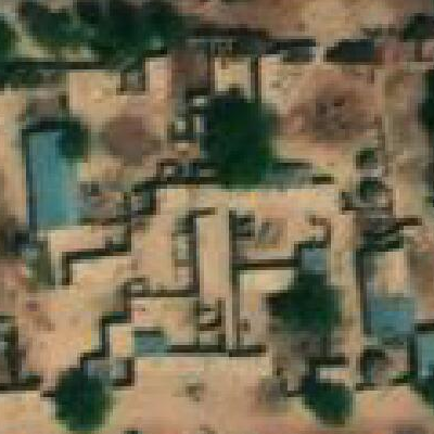
I think that when armchairing, it's good for one to not merely follow the clear-case instructions, but to actually understand what one's seeing. In doing some mapping across Africa, I'd like to understand the building and structures in the satellite imagery and so, by that understanding, hopefully map it more accurately.
In this question I'll focus on one feature I'm not familiar with.
1. 
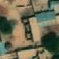
From walls and entrances (not shown), I believe this is two enclosed "family compounds", with back to back rectangular buildings along a shared wall. To my eye, the western building framed at center has three features coming off of it:
a) a tiny, short feature on the east half of its south end
two extensions off the west side,
b) the south one more round, and with a darker roof (or angled, and so, less reflective)
c) the north one more rectangular, and with a virtually identical to the main building roof color
Because this exact arrangement is so common, my take is that the rectangular part and a,b,c are all one building; functionally attached. c just has the same roof material. b is actually round on the ground. I hesitate on that though, since from the shadow, it appears the round part is not perfectly circular, and perhaps gets shorter as it extends west? Maybe it is rectangular, and just has a high-ridge roof?
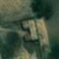
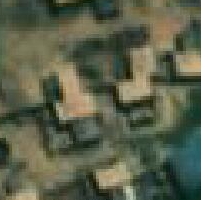
2. 
Again focusing on the parts coming off the main building, these could be anything from shade awnings right up to permanent additional space just with a different roofing material. They often look like this though; not rectangular (northern one), and even if they are, not square to the main structure (southern one).
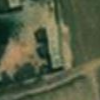
3. 
Two common African round houses, just attached. Oh, and the southen of the two has even more roof extending from it.
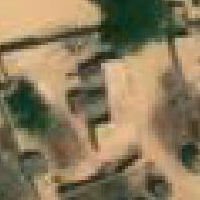
4. 
These are a bit different as they are smaller, and perhaps appear shorter given the shadows.
5. 
These are clearly lower in height. Right? Are they rather objects; squat, non-building structures?
The questions
Can you definitively clarify any of the above buildings’ shape and structure? What's that 1a thing? I'd really love to see ground-level or close-up aerial photos of these common building features.
My naïve approach so far: I'd map each of the above as a squared-corner rectangle (or L or T), with all the other structures mentioned above marked with Nodes where they intersect then Extruded out as part of the same building. Ehh?
asked 23 Jul '21, 01:16

Joel D Reid
166●7●9●16
accept rate: 0%
I think these are all highly pertinent questions, but am a little unsure whether this Help site is the best way to answer them in detail. I think many would benefit from discussion where people might be able to provide examples and/or additional interpretation.
Mmm. I'll leave it here in hopes for a site-appropriate "The Answer", but I'll also take my discussion/search for truth elsewhere. Thanks.
Rather than having everyone playing "through the keyhole" it would help to say where these tiny pictures are actually from. "Africa" is a big place...
Also, have you tried asking someone actually from the local area? You could trying contacting someone via an OSM mailing list or other community forum (see http://openstreetmap.community ). I do know that the OSM Africa Telegram group is quite active.
Thanks. I'll consider trying through there as well. This is help.osm.org; I just figured it was the most visible place to ask, so I started here—likely to get attention, and visible to others in the future mapping similar buildings. I have not asked anyone from the local area as I currently have no contacts nor affiliations in Africa. I believe these are from somewhere near Dan Tudu, Nigeria. But I just found some in Sierra Leone, Liberia, Niger, Cameroon, South Sudan, Kenya, and Somalia. Perhaps notable; those are all in a tall but distinct latitude range.