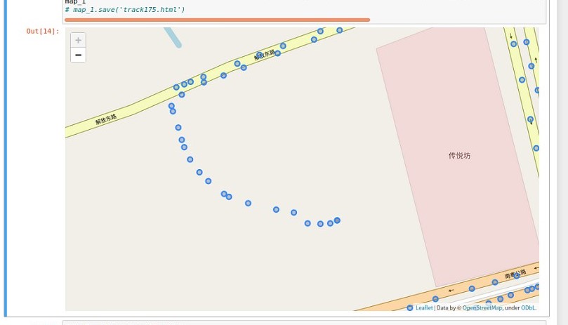
I asked if I could design a program to modify osm maps online a few days ago(cuz there are some errors in the map of OSM), someone replied that it certainly be a violation of the Automated edits code of conduct. I've been working on a map-matching algorithm. Due to a large number of errors in the OSM map, my algorithm performance is very poor, that's why I want to modify it. If I can't write a program to modify the OSM main database directly, I'd like to fall back on downloading an offline map of Shanghai and modifing it offline to test the performance of my map update algorithm. If this is possible, could anyone tell me how it should be done technically? Thank you very much!!!(The Blue Dots are GPS tracks, but there's no road on OSM) asked 13 Jul '21, 16:55 zjh1208 edited 14 Jul '21, 14:50 showing 5 of 8 show 3 more comments |
This is a static archive of our old OpenStreetMap Help Site.
Please post any new questions and answers at community.osm.org.
@mugwort I think it was this question.
The erros are too many kinds, the main problems are the road missing and the wrong direction of roads
Can you link to a specific example of a problem in OSM, and explain why you know that it is wrong?
@SomeoneElse ♦ I put a picture here
The existance of GPS points doesn't tell you what sort of road or path it is, though, does it?
Can several key points in the GPS trajectory be selected to generate a new path?@SomeoneElse ♦
@SomeoneElse ♦ what I need is to update the map, so my map matching algorithm could have better performance. As for the type of road, maybe it can be set to unclassified, but accessible for cars? Someone else can continue to update the road information in the future.
Please don't add random features to OSM based on GPS traces only. By all means use a combination of GPS traces and other information, such as an actual, on-the-ground survey or aerial imagery (provided that that imagery is appropriately licenced for use in OSM, and Google's is not).
You're actually best placed to fix the issue - you know there is a problem, and you're motivated to fix it. Expecting other mappers to provide you with a "free pony" is likely to lead to a long wait.
Incidentally, I agree with what Tzorn said over at https://help.openstreetmap.org/questions/80851/hi-everyone-i-am-very-happy-to-be-here-to-discuss-with-all-of-you-i-have-some-problems-really-hope-someone-can-help-me - "I think it would be much easier if you explained once in more detail what you are doing, how you are doing it and what you want to achieve in the end".