|
Greetings! I just submitted my first changeset, and am not sure I did it all correctly. https://www.openstreetmap.org/#map=19/45.37968/-122.74575 I'm going to start enhancing all the apartment complexes in my city with building and unit numbers. I've spent the last two days tinkering and learning how to use JOSM and OSM best practices. I want to make sure that my edits allow for searching with the apartment number. As in the map will route a person to the correct building/unit in the apartment complex. There was one building with the address for the apartments, I moved the addr tags to the area and changed all the buildings to building=apartments. Then I assigned flat numbers using just a single node. I included the apartment name in the area tag. Can someone tell me if this was the correct way to do apartments in my area. Thanks ... Scott |
|
In general I think what you did is ok. There are a few points to improve:
[update based on your comments below:] [earlier version: Is the "office" also having apartments in it? Otherwise change the building type. There is an Hi Scott. I'm a bit confused about the addresses still. Apartment numbers seem to be duplicated. There is an apartment 1 in each of the buildings A through H. Shouldn't the address then be something like this:? I'm asking because I think we need to get the building also into the By the way. Could you please use the comment function or edit your original question to add information. The "answers" should be reserved for solutions.
(26 May '21, 09:19)
TZorn
AHA!! Great point. I missed that. Those buildings would be addressed as such ... 19355 Southwest 65th Avenue APT B4 Tualatin, OR. 97062 I tried to convert the answer to a comment but got an error which mentioned trying again later. I copied what I could (didn't see a way to ad images)
(26 May '21, 23:45)
ScottProck
Also, regarding the elevation differences. The apartments get their name for a reason :) There are several areas where the property is on a steep incline, but I see your points. I can walk it and verify the elevation numbers, but your point with use is valid. I didn't want to delete any data that was previously there unless I knew for sure it didn't belong. Correct me if wrong, I believe most of the building data in my community was auto generated. I don't remember where I read it, but I remember reading they used LIDAR. Something else I picked up in my searching/reading (Outstanding Wiki, and community BTW) was that LIDAR is extremely accurate. The part of me that makes me feel uneasy with removing the ele info is the firm responsible for the automation is a reputable engineering firm. There's a possibility they have a use for the information being there.
(27 May '21, 00:22)
ScottProck
Your other points regarding addr:street and the office are great, and makes complete sense. To be completely honest, I'm still confused with the housenumber. It mentions a building with one entrance and multiple housenumbers. I believe it's a difference in terminology/definitions used. I have scoured the Wiki and literally soaking up as much information as I can, but there's so many different discussions around apartments with no clear consensus (at least as far as I've seen) This property looks to have been built in two phases. I was looking at each of the numbered buildings as having 2-6 entrances, but in reality, they're just a covered cutout with 4-6 door facing each other. Some buildings have 2-3 levels. Would each of these units (or flats???) be considered having separate entrances. You see, the 19355 is commonly referred to as the "address" but on most forms it's separated into the street number here. Those numbers are tied to the land (or according to our zoning/planning "plats") not buildings. Should I treat housenumber as 19355?
(27 May '21, 00:37)
ScottProck
Sorry for the flood, I just want to do this correctly. Here's my best understanding on how to describe how these apartments are setup? (not even sure if that makes sense) Rolling Hills has one address (street number or housenumber 19355) Each building has either a number or letter depending on the development phase. Each building has individual units each with their own entrance with each door being considered outdoor (not within a building with a main entrance to all units, such as our Hotels) Some buildings have pockets of two, four and six dependant on how many floors the building has. Hence, addr:flats=2-4 etc. The addresses would be written as such ... 19355 Southwest 65th Avenue APT 210 (or F4 on lettered buildings.) Tualatin, OR. 97062 That is how each unit would look with the only thing different about each unit is the APT number. The numbered buildings contain units that collectively never duplicate, therefore each unit has a unique APT number. Hence why the number for the building isn't used for them. I try to look for references that match the complex, but it appears this level of apartment detail is lacking in my area.
(27 May '21, 00:59)
ScottProck
Would it then make sense to place the entirety of the address onto each unit node, I mean that is how the address would look on paper. I just want to make our apartment addresses searchable, and able to be used for gps routing at least to the building number. There are some complexes out here that are so confusing, even the posted property maps make your head spin. The more I think about it, the more it sounds like this would be the best way to do it. Although I believe some to view it as overkill. There are some apartments with similar building setups, but each unit has a separate address (street or house number) We call them, individually addressed appartments. These type of apartments show up in map search as well as gps to their door. Should I model after those? That's all the ?'s for now, SUPER excited to get up to speed, and THANK YOU for the assistance/education. I only wish I would have gotten the bug many years ago :)
(27 May '21, 01:11)
ScottProck
A lot to digest. :-) I have updated my answer above.
(27 May '21, 09:49)
TZorn
showing 5 of 7
show 2 more comments
|
|
HiScott, Big problem here, you have the tag addr:housenumber=19355 on 55 addresses (18 separate buildings), so the house "19355 SW 65th AVE" is not unique. Another point, if the address is placed on an entrance node this makes for more precise routing to the address, please see:-https://wiki.openstreetmap.org/wiki/Key:entrance and https://wiki.openstreetmap.org/wiki/Key:addr:flats 1
But each part of 19355 has different flat numbers, see e.g. https://www.openstreetmap.org/node/8763012735 so does that not make them distinct?
(25 May '21, 10:12)
EdLoach ♦
1
I don't think it is a "big problem". Granted, many geocoders/routers will have issues with this way of tagging but in my opinion it does reflect the ground truth. But I think we also have to include the building ref in the address somehow. As far as I see flat number repeat across buildings. I'm unsure what would be the best way to do that. @ScottProck Can you give an example of how you would write the address of one specific tenant on a traditional letter?
(25 May '21, 12:13)
TZorn
in italy a situation like this is mapped by use of "interni", ie: addr:housenumber=19355/102. I guess nominatim (and others) cannot parse a space between housenumer and flat number... I mean, nominatim in "structured" search doesn't expect further details
(25 May '21, 12:34)
Cascafico
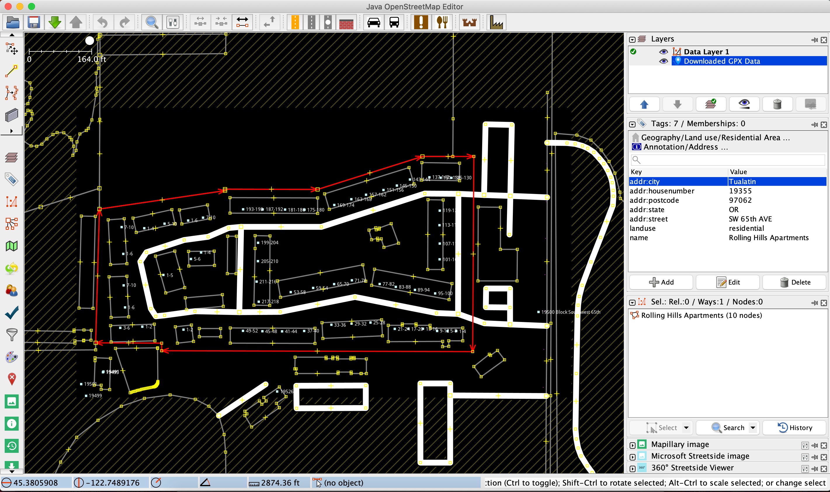
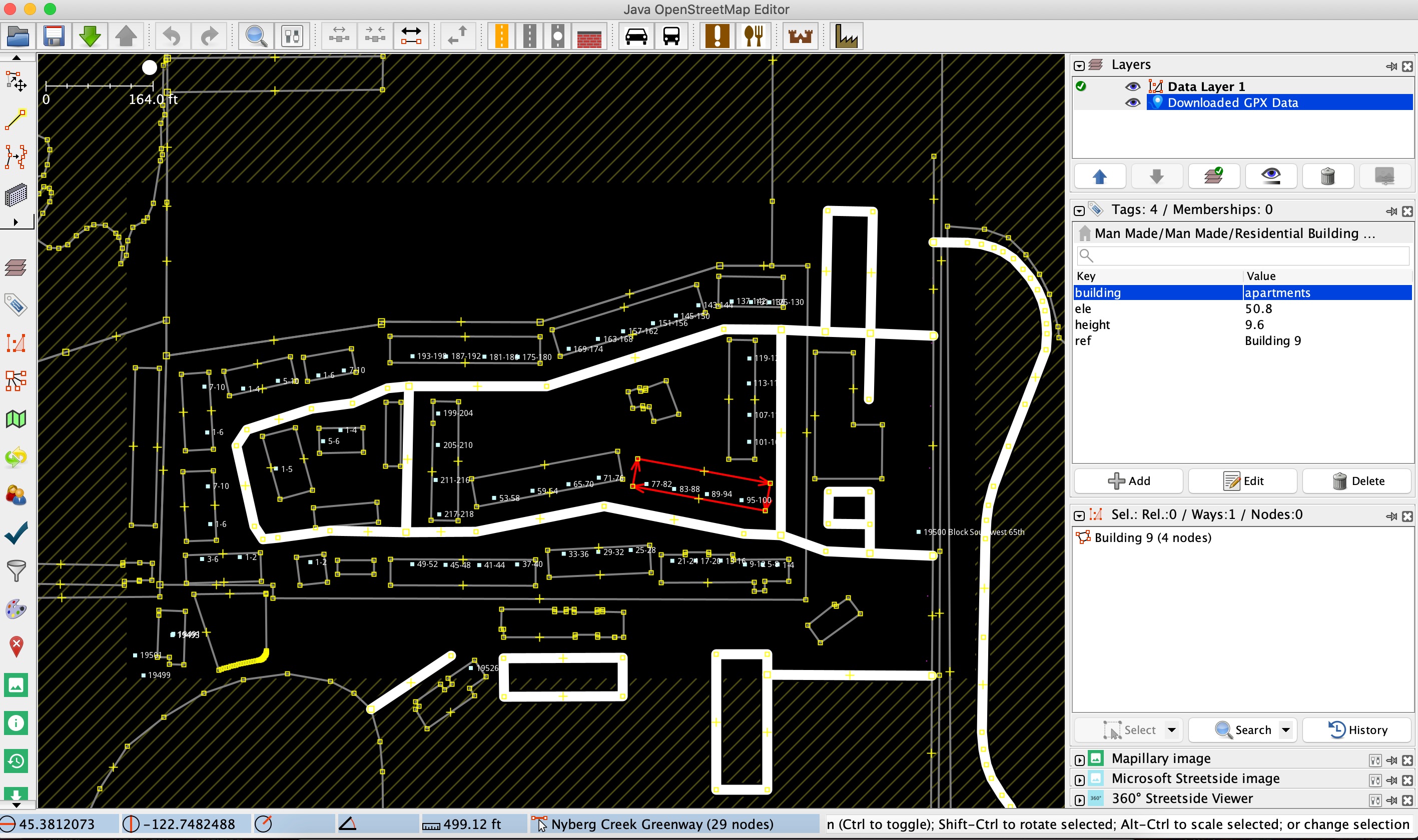
Thank you all so much for the reply. This is exactly why I want to do this right. The address would look like this is on an envelope. 19355 SW 65th Ave. APT 110 Tualatin, OR. 97062 The "APT" may be written as # instead. When I do a search including the APT (or using #) OSM returns no results. I'm confused and not understanding how every building shows the housenumber 19355 in OSM but when you view it in JOSM they are just as I added them. Each building was changed to addr:apartments with the name tag for the building numbers. Then I added a single node to represent each of the entrances with the respected flat numbers for that entrance. The only part that should have the full address is the area. I'm including screenshots. The first one shows the tags associated with the area. The second is one building that represents how I did each building. (edited, Moved to comment. Had in answer mistakenly. Tried to convert to comment but keep getting errors. ) (added, I'm still not understanding how each of the buildings have 19355 displayed on the map, but they're not there looking at it with JOSM. )
(26 May '21, 23:36)
ScottProck
|
|
Thank you all so much for the reply. This is exactly why I want to do this right. The address would look like this is on an envelope. 19355 SW 65th Ave. APT 110 The "APT" may be written as # instead. When I do a search including the APT (or using #) OSM returns no results. I'm confused and not understanding how every building shows the housenumber 19355 in OSM but when you view it in JOSM they are just as I added them. Each building was changed to addr:apartments with the name tag for the building numbers. Then I added a single node to represent each of the entrances with the respected flat numbers for that entrance. The only part that should have the full address is the area. I'm including screenshots. The first one shows the tags associated with the area. The second is one building that represents how I did each building.
|
Hello Scott and welcome in OSM.
Please, next time provide your username and/or link changeset number rather than map. Alternatively, one of the elements you have changed, so we can track back. AFAIK there's even a tag you can add to changeset to mark for review by others.
Anyway, looking at history in this area, I think this is you :-)
https://www.openstreetmap.org/changeset/105255309
Yes the changeset link is mine, thank you. I'll remember that for next time. :)