Recently Project-GC.com adopted OpenStreetMap for its Geocaching statistical analysis computations and many users have noted discrepancies between this Site's definition of county boundaries and the corresponding definitions from other sources. In an attempt to authenticate the accuracy of OpenStreetMaps data, we chose one example to examine: McCormick County, South Carolina. As best we could ascertain, OSM uses the Census Bureaus TIGER database for South Carolina, so we downloaded "The TIGER/Line Shapefiles and related database files (.dbf)" under the category "US County Boundaries" at the following site: https://hifld-geoplatform.opendata.arcgis.com/search. We plotted this data in Google Earth Pro and compared the boundaries of McCormick County, South Carolina in that Goggle Earth plot to those found here in OSM.org. They are not the same. We would like to understand (and correct as required) this discrepancy and, more importantly, we seek guidance on where we might find information one the specific data sources used by OSM.org in connection with its location of US counties. asked 24 May '21, 18:17 RW and VJ edited 24 May '21, 18:56 |
2 Answers:
You don't state where the discrepancies are located, nor their size. A simple screen grab of your comparison would help. Having said that, I'll try & answer the questions. US County data largely stems from an import of USGS data dated 2001, and as far as I can see has not been extensively modified since. The data was imported around 2008. This data may be somewhat generalised (e.g., similar to this dataset), and equally may not completely register with TIGER Line imported data (I recall some divergences in NW Colorado). Current TIGER Line is likely to be substantially more accurate than older versions. If the data is generalised this would not be noticeable for counties with predominantly straight boundaries, but obvious in places such as McCormick Co. SC. A quick scan of the area in an OSM editor does indicate significant divergence from a USSG Topo map layer, suggestive of generalisation of some parts of the boundary. For instance the boundary should closely follow Island Ford Road here, but instead is as much as 200 m out. (You may need to ensure you select the USGS Topo layer from the selector on the right-hand side of the editor). There exist pages on County Boundaries for some states, e.g., PA, which imply updates of boundaries from other sources (e.g., state GIS authorities). Summary: data were imported long ago, possibly from a less-detailed source, but unlike in some other states have not been subsequently revised. Recommendation: if you are confident that the boundaries are inaccurate they can be adjusted. I would suggest using the USGS Topo layer (but you could use TIGER Line as a custom layer). answered 24 May '21, 20:32 SK53 ♦ |
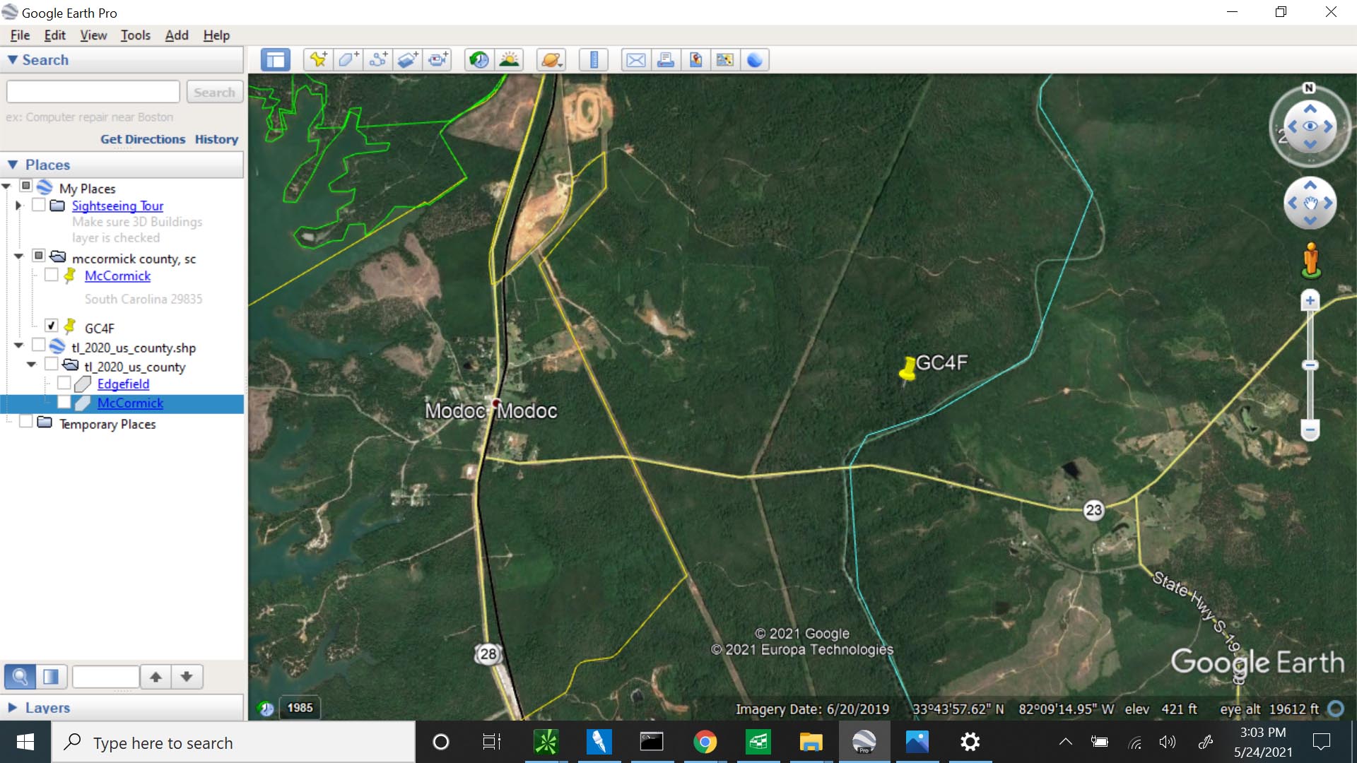
First, this is a new area of exposure for us, thus we are reluctant to undertake any changes without the direct oversight by an experienced OSM member. You may infer that we are not confident that the boundaries are inaccurate, only that we are unable to reconcile our TIGER download and plot against what we are finding on this site. The issue arises in connection with GeoCaching and, in particular, the location of South Carolina's oldest geocache, Modoc, GC4F, shown by a "pin" on the attached Google Earth Pro/TIGER plot. The TIGER data shows the county demarcation closely following the creek and squarely placing the subject GC4F cache in McCormick County. Your further elucidation and suggestions are greatly appreciated. answered 24 May '21, 21:22 RW and VJ edited 24 May '21, 21:23 1 I updated McCormick county SC to TIGER 2020 which appears to have better accuracy. I'm not sure how it would compare to official GIS data. It may take some time for GeoCache reference maps to update to match. Each county update is a time-consuming process since the original boundary may have been stitched to other objects and those should not be disturbed by a boundary update. (26 May '21, 00:58) Mike N |
An important addendum: unfortunately many other features in the area do not seem to have been updated from original TIGER data. This suggests low mapper activity, but means any corrections are very welcome.
We're uncertain whether we hit the correct "button" in replying to your response . . . so trying the "add new comment" button in case our original response was misdirected.
And a further question. If we upload a new TIGER Shape File for McCormick County, how will this impact the boundary definitions of the surrounding counties?