Why are OSRM and graphopper both routing foot traffic a long way "round the houses" when there's a much shorter bridleway directly the specified points?
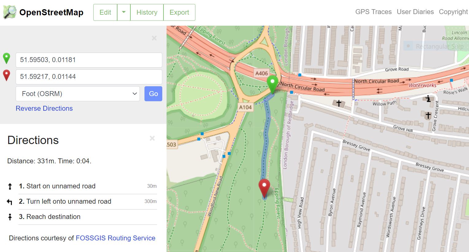
See https://www.openstreetmap.org/directions?engine=fossgis_osrm_foot&route=51.59491%2C0.01149%3B51.59436%2C0.01163#map=17/51.59244/0.01339&layers=N and https://www.openstreetmap.org/directions?engine=graphhopper_foot&route=51.59491%2C0.01149%3B51.59436%2C0.01163#map=17/51.59244/0.01338&layers=N There have been no mapping changes to the bridleway since 2016. If the reason is that the bridleway is not tagged foot=yes, then something needs fixing because according to https://wiki.openstreetmap.org/wiki/Tag:highway%3Dbridleway the bridleway tag already implies foot=yes. asked 12 May '21, 22:59 harg edited 12 May '21, 23:04 |
3 Answers:
It's pretty easy to come up with "router fails" with the routers on osm.org, to be honest. This is one that I came up with a while ago. To be fair to the routers on osm.org, they're basically there to show that you can use OSM data for routing rather than give you a perfect route in every place in the world. They're not trying to make sure that they follow the different routing rules for each country - and those routing rules aren't hard and fast, as the asterisks in some of the tables make clear. This answer is marked "community wiki". answered 12 May '21, 23:52 SomeoneElse ♦ About your "fail", I guess they didn't imagine sidewalks on trunk road ! Sounds scary. Or maybe they don't take sidewalk into account at all (yet)... In that case, I understand blacklisting trunk roads for foot routing. But yeah, 15km detour seems harsh... ;-) (13 May '21, 00:21) H_mlet Think that's scary? Try cycling on a motorway! (13 May '21, 00:27) SomeoneElse ♦ |
Actually the text of the wiki page shows that England legally has foot=yes and Germany doesn't. And the defaults page (which routers might use) says that bridleways are only for horses internationaly. I'm not sure the country level defaults are used by any router. You might want to test in various countries. So the infobox "Implies... " is misleading and should probably be changed to "Useful combinations". And you should probably add foot=yes to the shown bridleway if you're sure it's allowed. Regards. answered 13 May '21, 00:12 H_mlet |
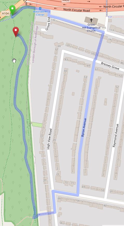
I think they will route successfully if tagged foot=yes. I have added foot=yes and bicycle=yes to the bridleway. It should route soon, maybe a day. I often use an online app ( which i don't want name, it also displays copyrighted maps that have usage limits) to create gpxes and it seems to work if the above tags are present. Other will disagree. UPDATE I am fairly sure this Bridleway can be used by walkers. If I lived close by I should survey it and note local signage before tagging it. The routeing with OSRM now does as expected. see pic
answered 13 May '21, 12:02 andy mackey edited 14 May '21, 13:14 We don't actually know the legal status of this bridleway (https://www.openstreetmap.org/way/42328362 just has "highway=bridleway", there's no "designation" tag). Generally speaking adding "foot=yes" to fix a router bug is a bad idea, since it downgrades the value of where people know that "foot-yes" is actually correct based on actual survey or knowledge of the legal status (e.g. if a local authority's public footpath data has been made available to OSM under a suitable licence). In this case it's probably a public bridleway and so this tag is quite possibly correct, but it really needs more information. Perhaps you could investigate whether there is licence-compatible data from the local authority that OSM could use to tag it properly as a "public_bridleway"? There's nothing at https://wiki.openstreetmap.org/wiki/Local_councils_in_the_United_Kingdom unfortunately. (13 May '21, 12:17) SomeoneElse ♦ I'd assumed the questioner knew it is a bridleway, and in England bridleway is foot=yes but I should NOT have assumed. I'll research a bit more or maybe "harg" can confirm the legal status or official signage of that bridle way. (13 May '21, 12:56) andy mackey For completeness, "highway=bridleway" in England and Wales just means "designed for use by horses" (as it does elsewhere in the world) not necessarily "designation=public_bridleway" (which is what a "public bridleway" sign would imply). Permissive bridleways are pretty common - https://www.openstreetmap.org/way/39589904/history is one I found a couple of weeks ago. That example of mine is designed for use by horses, and horses are currently allowed to use it, but that's only by permission of the landowner and that permission can be withdrawn at any time. (13 May '21, 13:51) SomeoneElse ♦ I'm confused this disagrees. https://www.gov.uk/right-of-way-open-access-land/use-public-rights-of-way (13 May '21, 14:05) andy mackey I have added a note to the map is this a footpath ? (13 May '21, 14:07) andy mackey Not all ways "designed for use by horses" are in England/Wales legal terms "public rights of way". If you see a sign at the end saying "Public Bridleway" then it is, but many others (like the example I linked to earlier) don't have that legal status. Hopefully your OSM note "is this a footpath and cycleway what do the signs say? please" will get people to report what signage there is, but the OSM terms highway=footway, highway=cycleway and highway=bridleway don't correspond one to one with English/Welsh legal statuses. It's quite common for a cycleway to have the legal status "Public Footpath", for example: https://www.openstreetmap.org/way/485751846 . (13 May '21, 14:48) SomeoneElse ♦ 1 "maybe "harg" can confirm the legal status" Unfortunately, although Waltham Forest has the statutory duty to maintain the definitive Rights of Way information for the area, there's no statutory duty to make it available online and Waltham Forest does not do this. And so far the only place where I can find it described as a bridleway is on OSM. What I can say is:
So it seems it's definitely available to the public for walking (horse riding requires a licence) but may or may not be a statutory bridleway (13 May '21, 14:55) harg Actually, it looks like a permit is required for horses in Epping Forest: https://www.cityoflondon.gov.uk/things-to-do/green-spaces/epping-forest/apply-for-a-licence-in-epping-forest/horse-riding-in-epping-forest . In the past I've mapped this sort of thing like https://www.openstreetmap.org/way/142216479 - but that might not be the best way. (13 May '21, 15:03) SomeoneElse ♦ I found this. Which suggests we can walk the path .https://eppingforestheritagetrust.org.uk/wp-content/uploads/2019/09/epping-forest-map.pdf (14 May '21, 15:04) andy mackey showing 5 of 9 show 4 more comments |
I had to reactive the map note, after it was resolved without comment ?? just a tidy up? It was then commented on very comprehensively by user thanks "harg"