Hi, can one explain why here https://www.openstreetmap.org/directions?engine=fossgis_osrm_foot&route=57.32642%2C-2.83276%3B57.32609%2C-2.83762#map=16/57.3284/-2.8349 not the short direct route on the red-dotted footpath is used? I added this path two days ago (I'm relatively new to OSM). I also read this suggested post https://help.openstreetmap.org/questions/7015/tagging-public-footpaths-for-routing and tried to find out which data is used by the "Foot (OSRM)" and "Foot (GraphHopper)" route planners. From what I understood the planners don't necessarily know the current state of OSM, but I did not find an easy way to determine which version of OSM data is used in these route planners. Where can I see this? Thank you & Best regards asked 05 May '21, 11:34 BlaMa |
4 Answers:
For OSRM, it should be daily updates, for the FOSSGIS sponsored routing server. You can even find timestamps on this page. answered 05 May '21, 12:11 H_mlet 1 Hi @H_mlet, thank you, I can see the date in http://map.project-osrm.org/timestamps/footeuasi.data_timestamp It's more than two days since the last update (2021-05-03T08:00:00Z ) and this explains my issue. Also, GraphHopper is now using my foot path for foot only, which is what I wanted. I wasn't sure my edit was correct, but now I am. (05 May '21, 13:00) BlaMa There have been a few hiccups with the FOSSGIS OSRM server over recent days which the server admin is working to sort out, I believe. (06 May '21, 19:25) Richard ♦ |
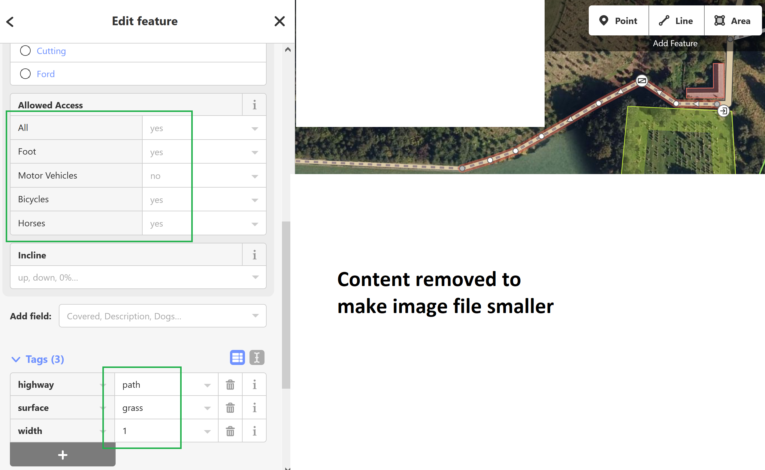
Answering @andy-mackey 's questions: It's working for me using GraphHopper now (see my answer to @H_mlet). When I made the post, OSRM just did not use my path, but worked in general. I use the openstreetmap in-browser editor to edit and added foot=yes, see this picture: answered 06 May '21, 18:51 BlaMa Thanks everyone. Andy (06 May '21, 23:45) andy mackey 2 What you see there under Allowed Access are implicit access rules, iD assumes. Maybe it uses the access defaults tor that, but I am not sure. Notice that the values are shown in a light grey. The actual tags that you mapped are the ones on the bottom. In your case there are only By the way: OSRM is working again and routing via that way (even without any (07 May '21, 09:18) TZorn Thanks TZorn fro spotting that. (07 May '21, 19:30) andy mackey |
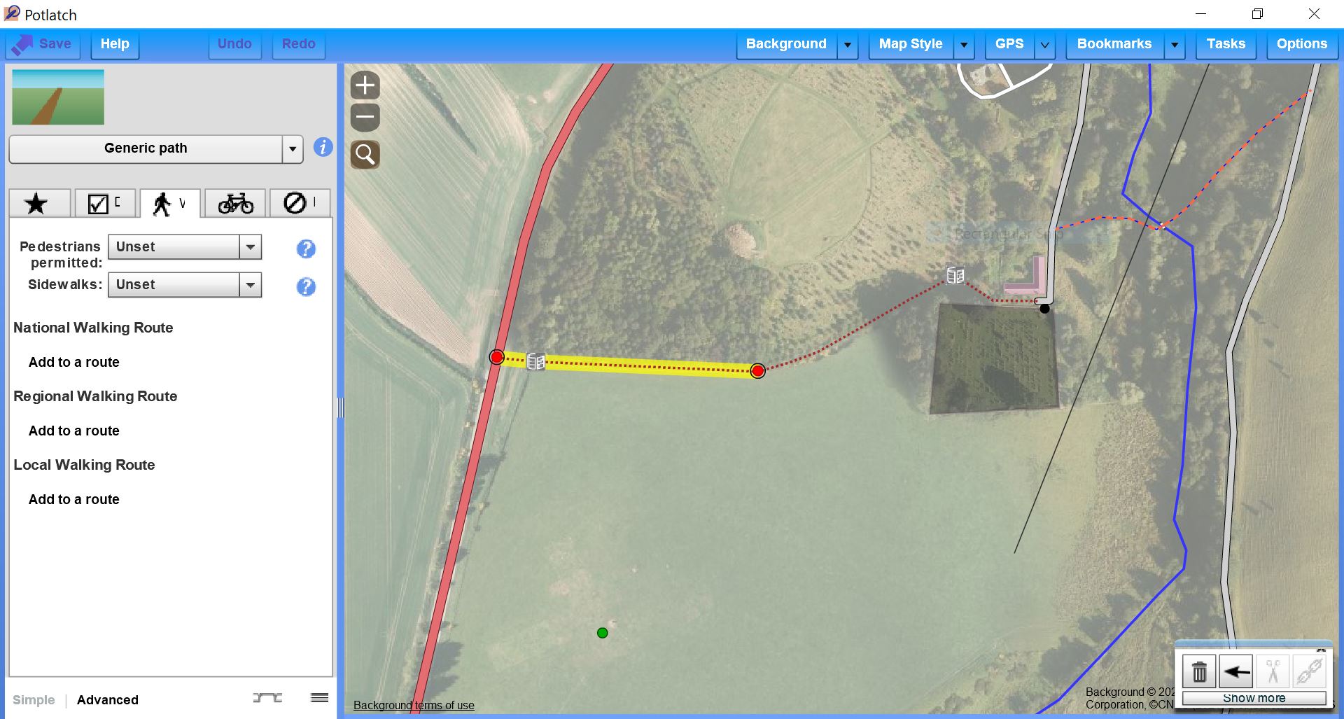
I think path needs an additional tag such as allowed or designated. The router doesn't route on private path or track. Check with local government somehow for status. Best to do a survey or walk it and read the official signage and use your GPS trace a camera, dicta phone or notes when surveying for later mapping a path or track. answered 06 May '21, 14:18 andy mackey edited 06 May '21, 14:22 2 I don't agree. If no access tags for a path are given the router should either default to access=yes at least for non-motorized traffic or use the proposed default rules. I'd say paths mapped without access tags are pretty common. (06 May '21, 14:48) TZorn You may be correct, Scotland has a right to roam. Which would suggest you can walk anywhere (almost). # In the UK I have found the routers that didn't work for me did after i added designated or allowed to the paths but i was never quite sure because updating OSM used to have a bigger delay on OSRM and Graphhopper. Confirmation from other mappers and users of footpaths well be useful. (06 May '21, 15:26) andy mackey 1 All the routers I've used default to foot=yes on paths without access tags... (06 May '21, 15:52) H_mlet Thanks TZorn and H_mlet. Ways i mapped with P2 as foot or bridleway didn't automatically get a foot=yes tag I have just add one here. and it should work soon. https://www.openstreetmap.org/directions?engine=graphhopper_foot&route=52.34107%2C-0.34661%3B52.33250%2C-0.34756#map=15/52.3357/-0.3401 (06 May '21, 16:12) andy mackey If you look under the advanced tag on BlaMa's path it doesn't have foot=yes . I guess foot=yes needs adding as well. Potlatch doesn't add automatically if you select footpath i haven't check if JOSM and iD do. The path shows on the map BUT may not route without foot=yes being added. Feed back welcomed. (06 May '21, 16:31) andy mackey I couldn't see what editor had been used by BlaMa, i have forgotten how to get that info. (06 May '21, 16:33) andy mackey Hi all, thanks for chiming in. I'll add a comment with picture to the main thread. It's working for me using GraphHopper now (see my answer to @H_mlet). When I made the post, OSRM just did not use my path, but worked in general. I use the openstreetmap in-browser editor to edit. (06 May '21, 18:46) BlaMa 2 Andy, what H_mlet and I are trying to say is that BlaMa does NOT need to ad a As I commented on the question: Currently, I cannot calculate any route with OSRM anywhere. So unless it's different for you it's a bit futile to try/guess around now why it does not route over this one path. (06 May '21, 18:57) TZorn 1
In reality, that's a very foolhardy assumption for bikes. Many mappers use highway=path for paths without any right of access for bikes. (06 May '21, 19:25) Richard ♦ showing 5 of 9 show 4 more comments |
Routing servers don't update as fast as Mapnik tile server. I guess it's because updating vector DB is more cumbersome than raster one. If you are in a hurry, try telegram bot @RoutinoBot In a few secs, it will update routing around geocoordinate you'll attach (area approx 2 square mile) answered 10 May '21, 09:02 Cascafico |
OSRM on www.openstreetmap.org does not find any route anywhere currently. There seems to be some general problem with the engine not with your path.