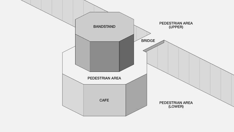
I'm at a bit of a loss for how to draw this feature correctly...
I have been using asked 04 May '21, 18:13 Foomandoonian |
One Answer:
I'm guessing this is the Brighton Bandstand at https://www.openstreetmap.org/way/96655710? (Full disclosure -- this building was a little jagged and I just uploaded a changeset to make it into a regular octogon.) [Answer has been edited to reflect info from the comments below -- thanks @alester @Kovoschiz and @SK53 for the insights!] For the bridge, I'd probably use a linear I'd also use an octagonal linear footway to indicate the walking area around the bandstand, on the cafe roof. Mapping this as an area in addition or instead would also be possible, but I don't feel that it qualifies for As discussed in the comments below, it's possible to map a 2-D "foot area" as either Furthermore, there's a distinction between omnidirectional highway areas for mapping plazas and other situations where traffic can go anywhere and might enter and exit at a variety of locations, and linear highway areas for adding shape and width details to an already-mapped one-way or two-way linear highway. The omnidirectional areas should get two tags -- Whatever method you ultimately choose, take care that your upper and lower highways don't share any nodes, or routing software might send people jumping off the bandstand level to the cafe below instead of using the steps. answered 04 May '21, 20:43 jmapb edited 05 May '21, 15:17 showing 5 of 8 show 3 more comments |


Ah, thank you. I will try to make sense of that when I get back to my drawing tonight.
And yeah, my work that I haven't uploaded yet already includes a better octagon, so it'll be interesting to see what happens when I save! Most of the building shapes have been very rough and I'm improving them all as I progress east.
A foot area where vehicle traffic never travels (or is only accessed rarely by authorized service vehicles) could be mapped as
highway=footway+area=yes@Foomandoonian Ah sorry about that, my octagon compulsive disorder got the best of me. I didn't add or delete anything, just re-aligned the nodes, so it shouldn't be too much of a pain. It looks like you're mapping with iD, so you should just be able to select "Keep mine" (mine meaning yours) to overwrite my changes when you save.
@alester Yep that makes sense. Haven't seen it used much but scouting around on Overpass I see that it's actually more common than I thought. But highway=pedestrian still appears to be far more common. I think one reason is that polygonal footway areas are very often called "pedestrian areas" IRL, and another is that it's rare to find one that doesn't have some allowance for emergency or delivery traffic.
We have linear
area:highway=footwayand omnidirectionalhighway=footway+area=yes. "Pedestrian area" is caused by the ambiguous iD preset name seemingly not considering the definition of=pedestrian.@Kovoschiz highway=pedestrian + area=yes has a long usage for mapping the areas of footways. I would agree this is not absolutely correct, and at a minimum they can be changed to highway=footway + area=yes without losing their ability to be rendered.
Thanks folks, I've edited my answer to incorporate your insights.
@SK53 At the very least, the situation is worsened by using a preset name not carefully thought about, regardless of what common terminology may be. When created in 2007, https://wiki.openstreetmap.org/w/index.php?title=Tag:highway=pedestrian&oldid=55318 already has "Vehicles may be allowed in", "The "footpath" tag seems a bit inappropriate for such things.", and "a pedestrianised road".
@Kovoshiz I happen to agree with you, I am merely commenting on what actually happens, not what I would like to happen :-)