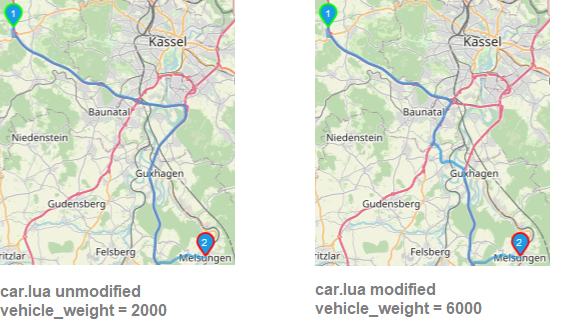
Hi all, I am experimenting with the "Open Source Routing Machine" (OSRM) and it's profiles. Currently I am facing a phenomenom I discovered running OSRM via docker in my custom setup: A route changes noticeably if the weight of the vehicle is changed in the car.lua profile. So I think that somewhere in the route there must be a node/way/relation with restrictions of weigth, which causes the discrepancy. How can I search for weight restrictions in a route? Or does anyone has a alternative explanation for the discrepancy? The affected route starts in Burghasungen and ends in Melsungen. Both locations are cities in Hessen, Germany. Using the OSM routing service with default car.lua you can see the route here: https://www.openstreetmap.org/directions?engine=fossgis_osrm_car&route=51.3246%2C9.2777%3B51.1298%2C9.5437#map=10/51.2391/9.1763 In my setup the discrepancy looks like this: Even with the weight of 6000 kg I would expect the route to continue up to the end of A44 and not to leave the A44 premature (A44 should be tagged highway=motorway). I case you wonder what my motivation is: Actually I would like to use a profile called "truck soft", which can be found here. This truck profile uses car.lua as default and changes different aspects. But using this truck profile I discovered the above described discrepancy. Thus I stepped back, took the default car.lua and tried to applied the changes one after another. By this I found out, that only changing the "vehicle_weight" (leaving the rest untouched!) leads to the differing route. The data I used is the sub region Hessen kindly provided by Geofabrik. Interesting additional detail: Using an older dataset, which is round about 4,5 years old, the route does not change on different weights. Thanks and greetings, rebos asked 11 Apr '21, 16:02 osmrebos |
One Answer:
Maxweight of way 34287495 and a few other ways on the eastbound carriageway appear to be tagged as 3.5, with the default unit being metric tonnes. Changeset 70382652 also has the comment "A44 gesperrt 3,5 ton " so I assume this is not accidental. Found via an overpass turbo query on the maxweight tag. As always, please be sure to check on site, or with very recent street level imagery before making any changes to the mapped data. answered 11 Apr '21, 17:59 InsertUser |
My curiosity got the better of me: here's an article about the change.