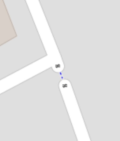
There are a couple of gates at the end of roads near me marked on OSM as shown in the following screenshot, i.e. two gates with a cycleway connecting them:
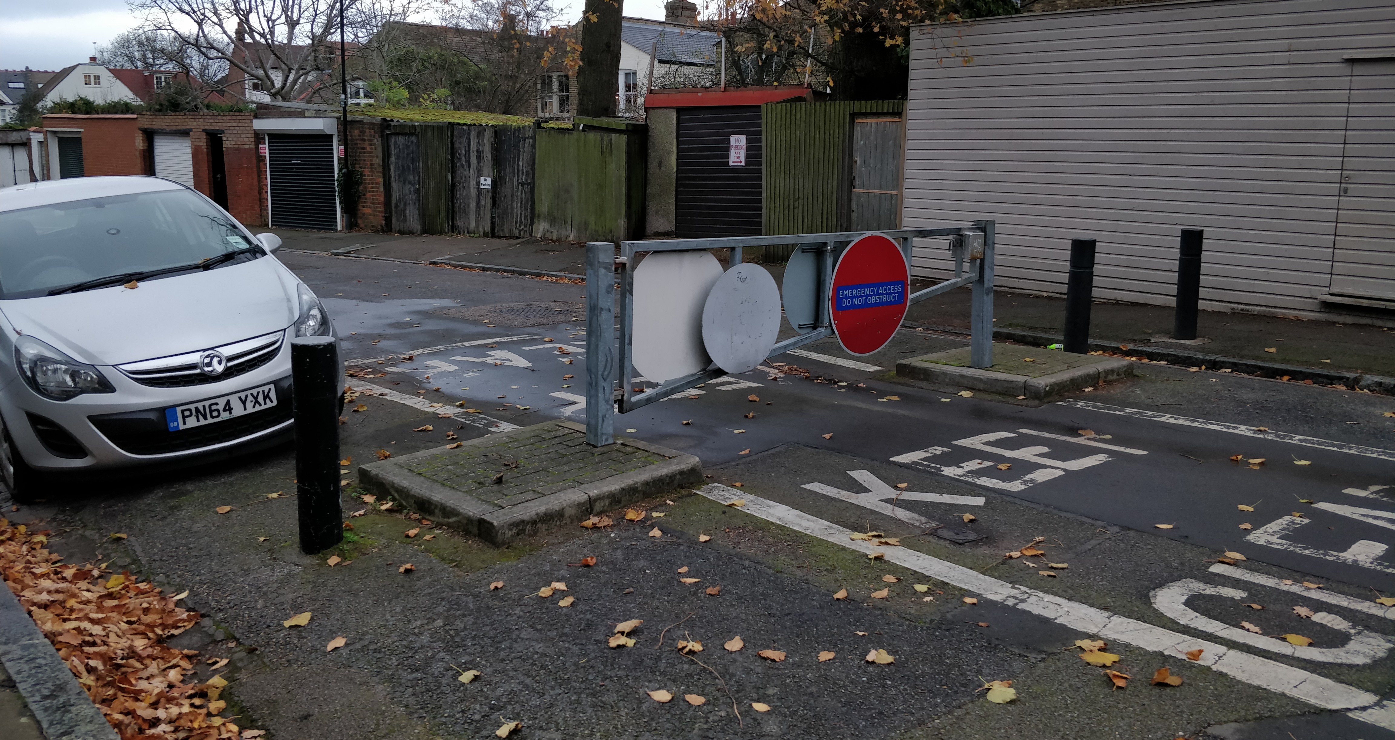
Here is how one of the gates appears in real life:
As can be seen, it's a single gate which may only be opened to pass by emergency vehicles. It has space either side for bikes and motorbikes to pass (the car on the left probably shouldn't be parked there). My question is whether this a correct representation of this type of gate. It seems correct in that it shows that civilian vehicles can't pass while bikes can (assuming that everything is tagged correctly), but fails to represent what's actually there, plus the cycleway doesn't permit emergency vehicles. Suggestions for what to replace this with or how to improve it would be appreciated, or an explanation as to why this is in fact correct. I feel it's more complex than a simple gate given the access allowed to bikes etc. Thanks in advance for any help! asked 28 Nov '20, 00:32 danmiz edited 28 Nov '20, 13:11 |
4 Answers:
The current mapping looks good to me except that the single gate would be better placed as a midpoint on the cycleway, rather than on either end. You could potentially add emergency=yes to the cycleway to indicate emergency vehicles are allowed along it, but I wouldn't worry unduly: emergency vehicles will (rightly) go where the hell they want to go whatever the sign says, and I'd be horrified if they were using OSM for navigation anyway! The problem with doing a "bypass" is that the right angles can mislead routers into saying "turn left, turn right" when in fact it's a straight-on. OSM's data model falls down a bit in these situations - see this talk by Martin Lucas-Smith: https://2019.stateofthemap.org/sessions/DW7WW8/ answered 29 Nov '20, 12:11 Richard ♦ edited 29 Nov '20, 12:12 |
Broadly in OSM the actual topology is often more important than the precise geometry. In cases like this there are at least 2 (probably 3) topological routes:
Similar features are encountered in a number of places : on public footpaths on a track where a gate may be traversable if open but there is an adjoining stile; many traffic calming schemes such as recently introduced low traffic neighbourhoods. So in summary your current mapping looks OK, but I'd change bridleway to cycleway, and refine access tags on the gated section of road. answered 28 Nov '20, 20:43 SK53 ♦ Thanks for such a detailed answer. You say that a roadway with a gate is a good option, but also that the current mapping (not mine btw, I'm looking to change it) looks good. Do you mean to say that the solution proposed above by Andy is sufficient? I'd considered it but was concerned about inaccurate geometry, though it now seems like a good idea since you pointed out that topology is the most important factor. (28 Nov '20, 21:20) danmiz |
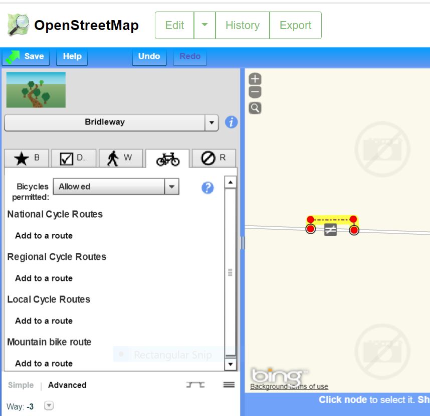
Some thing like this could be a solution. answered 28 Nov '20, 19:54 andy mackey Now there's a screenshot that brings back memories. Are you testing version 3? (28 Nov '20, 21:44) InsertUser I didn't know there is a v3 (28 Nov '20, 22:23) andy mackey |
It looks like there is no prohibition for mofa, moped, motorcycle, horse, single tracked transportation modes. If these transportation modes can pass or are not prohibited. The bypass, cycleway and bridleway is not correct. Defaults give a prohibition. If, contrary tags must be set, oft forgotten! This is to the disadvantage of these transportation modes. Contrary tagging must be avoided. It may give incorrect tagging more often. =path is also not entirely appropriate, because of country default but beter then the others. Country default is often not adapted to these single_tracked use. Main road is still residential service or unclassified. answered 29 Nov '20, 17:27 Allroads edited 29 Nov '20, 17:31 |
Please show the location on OSM we can then look at the tagging and suggest or even modify it.