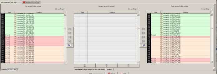
Hi I'm attempting to revert someone elses changeset in JOSM. It's giving a conflict for a route relation. I need a few things clarified. AFAIU there are three states: Before the changeset, After the changeset & subsequent edits in another changeset. Which is the 'My Version' (Left)? Which is the 'Their Version' (Right)? What does the pale orange/peach(?) coloured entries signify? Is there a reason timestamps couldn't have been added? It would have made it so much clearer?
asked 17 Nov '20, 19:22 DaveF |
One Answer:
There's 2 states, the latest server version (their) and the local version (my). The version you downloaded is also on the server, as a previous version (but it's not tracked for the conflict). The pale items are present in both versions but not in the same position. There's some help on the JOSM wiki: answered 17 Nov '20, 21:53 maxerickson |
I'm still a bit confused.
OK
The state of the database after the changeset edit, yes?
The state of the database before the changeset edit, yes?
OK
Which, after reading, I needed to post this question.
There's 2 states that are relevant to the conflict. "their" and "my" have both replaced it…it's just that one of them has done it on the server and one hasn't.
@DaveF the dialogue was not created with reversion in mind. I think the dialogue assumes that what happened was this:
In some cases you may both have been refining distant areas of the same coastline so it makes sense to keep elements of both lists of nodes. In other cases you may have both tidied the same building to slightly different imagery in which case a merge would only re-introduce distortion. In the case of a reversion you probably need to determine whether the other mappers edits are an improvement on what was there before the changeset you're trying to undo.
You could use achavi to assist in seeing the other persons changes since you started editing. Zoom to the area, select bbox and draw a rectangle around the area, adjust the 'start date and time' entry box if necessary and select load. This will give you a clearer understanding of what 'their' edits were.