NOTICE: help.openstreetmap.org is no longer in use from 1st March 2024. Please use the OpenStreetMap Community Forum

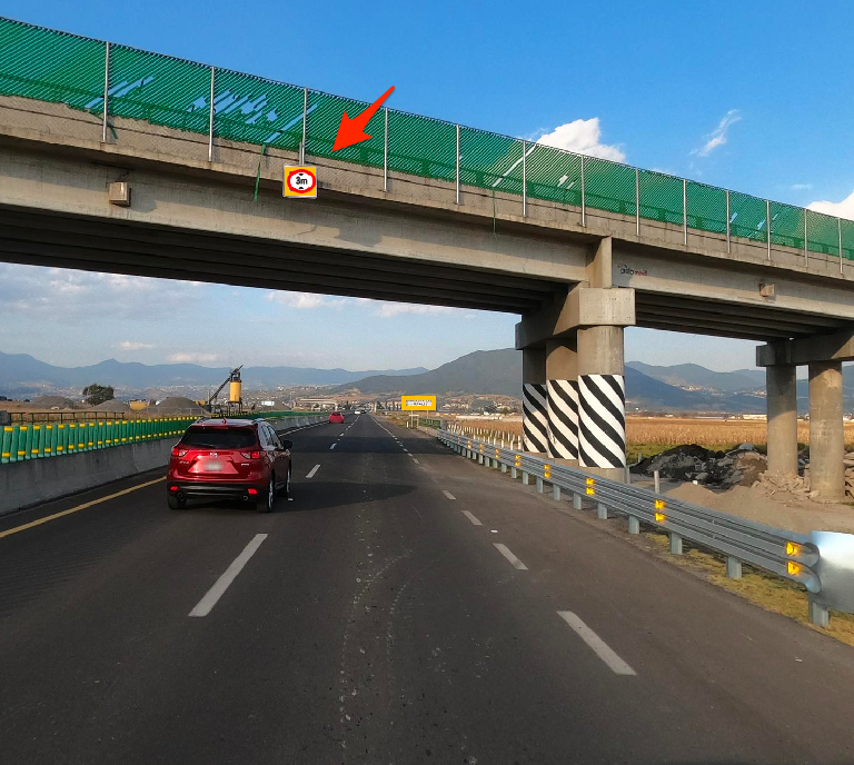
I don't know which is the correct way to tag the maximum height limit for vehicles using a highway, if the maxheight sign is on the bridge.

1 Do I tag the bridge?

highway=primary
bridge=yes
layer=1
maxheight=3.8 m

2 Do I tag the road below the bridge?

highway=primary
maxheight=3.8 m

This is a sample image of a bridge with a maxheight sign

There is also the tag maxheight:physical. Which to use?

asked 11 Nov '20, 06:09

mdelatorre's gravatar image

mdelatorre
1773411
accept rate: 0%

edited 11 Nov '20, 06:11


You have to tag the road below. If necessary split the road in three pieces at the points where the road passes underneath the bridge. Then tag the piece underneath the bridge with the maxheight. In your case it looks like the road is not made as access to any other place except going forward. So it might be ok to tag the whole stretch of the road with the maxheight (assuming a truck with more than 3m would not use this road to go anywhere else than pass under the bridge).

Use maxheight. This is the main tag used by routers. maxheight:physicalcould be used if legal and physical maxheight differ.

permanent link

answered 11 Nov '20, 07:57

TZorn's gravatar image

TZorn
12.3k764225
accept rate: 15%

Thanks for your help!

(16 Nov '20, 04:04) mdelatorre
Your answer
toggle preview

Follow this question

By Email:

Once you sign in you will be able to subscribe for any updates here

By RSS:

Answers

Answers and Comments

Markdown Basics

  • *italic* or _italic_
  • **bold** or __bold__
  • link:[text](http://url.com/ "title")
  • image?![alt text](/path/img.jpg "title")
  • numbered list: 1. Foo 2. Bar
  • to add a line break simply add two spaces to where you would like the new line to be.
  • basic HTML tags are also supported

Question tags:

×163
×71
×3

question asked: 11 Nov '20, 06:09

question was seen: 1,173 times

last updated: 16 Nov '20, 04:04

NOTICE: help.openstreetmap.org is no longer in use from 1st March 2024. Please use the OpenStreetMap Community Forum