Hi, I'm totally new to (contributing to) OSM, but I'm out on the Navajo Nation reservation near Chinle AZ USA, driving around using the OSM for the area. Most everything has been very accurate, but yesterday I encountered a road that has been moved & would like to (1) get the data from my track submitted correctly here as an update or a proposed update to OSM, and (2) learn how to properly submit this myself, ideally from my phone, since I'll be driving around here for another week and might encounter this again. I've been using Maps.Me (I know, boo, hiss), but so far I haven't been able to have the same functionality with OsmAnd, but am open to learning how / using both together (if possible) to record tracks. Given that all of this seems to be pretty advanced, hoping I can set up a Zoom (or other screensharing) meeting with someone to learn how to do this in person. I'll next be available tonight 9pm MDT (3am UTC), and could get up early tomorrow to meet before starting my work day at 8:30am MDT (2:30pm UTC) ...so that could be around 7am MDT (1pm UTC). I appreciate this may not be possible to arrange, but thought I'd try. (I know it's very annoying to have a newbie stop by without taking the time to read the project documentation, but because this is such a rural area I want to try to make this submission.) KM asked 26 Sep '20, 15:53 kmolo |
3 Answers:
I have found the mobile phone based apps much harder to use than the desktop based tools. Simple things like adding or updating an existing point of interest aren't too bad, but adding or moving a road (trivial on the desktop) is way beyond what I'd try on my phone. Is there a pressing reason for updating the OSM data on this today or tomorrow versus sometime later when you have access to a laptop or desktop computer? Apps like Maps.me and OsmAnd only update their map data about once a month so any changes that are being made now will not show up for a little while anyway. answered 26 Sep '20, 16:00 n76 |
OsmAnd does allow direct in-app editing of POIs and can record trips, but these functions need to be activated through the plug-ins app first. If you have a track recorded with OsmAnd you can upload it to OSM.org from within the app to use as a background when editing on a desktop computer. If you would rather edit directly on your phone then the best solution on Android is Vespucci. I find it a little cramped compared to a desktop editor, but that seems inevitable on a phone. There is a general introduction to the app available here. I have no experience with editing on iOS, but Go Map!! seems to be the current favourite. LearnOSM.org has beginners guides for OSM in general plus specific tutorials for the two mobile apps mentioned above. answered 26 Sep '20, 17:30 InsertUser edited 26 Sep '20, 23:09 |
I'll make sure to do this going forward with OsmAnd, but the one that I have so far is just the dotted track in Maps.Me I don't think I'll be able to drive back & re-record that correction, so trying to figure out how to save this.
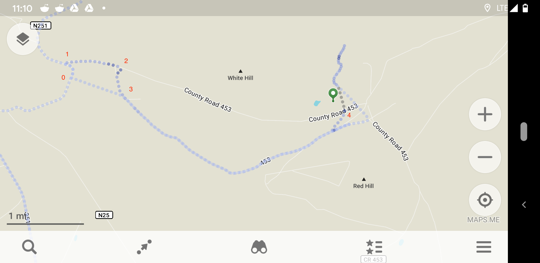
answered 27 Sep '20, 18:21 kmolo This is a screenshot from my phone of the track. It's from the Flagstaff AZ USA map. Point 1 (GPS 36.011351, -109.829628) is where the road showed County Road 453, but it's actually at Point 0 (GPS 36.008726, -109.828023). Point 1 actually looks like someone's super overgrown, rutted driveway, which was very hard to traverse with an SUV's clearance. At Point 2, I ended up at a dead end, in a family's property. From Point 2 to Point 3 was how I drove out, again not really public roads, more like the exit from their property, rejoining actual County Road 453 at Point 3 (GPS 36.004935, -109.815676). Basically that "County Road 453" from Point 1 to Point 4 (GPS 36.002633, -109.764447) should not be on the map anymore. From actual County Road 453, I drove into Point 4 on a super rough driveway track, but that's not really a road either. Point 4 is actually where the house I visited was, not at the green pin. Then I drove over to another property, up its driveway, and then returned to original point, and drove out on actual road meeting up with County road 453 again. Took a right, and returned the way I came in order to get out of there before nightfall. (27 Sep '20, 18:33) kmolo I have to head out now, but can add more detail / GPS points, and I hope save this somehow for submission. (27 Sep '20, 18:33) kmolo |
Thanks stf,
What data is necessary for me to collect, so that I will be able to provide the update later?
I'm only going to be here for a week, so don't want to collect incomplete data & therefore not be able to provide what is necessary to submit the update. Is a map track sufficient? Presently it would likely be in larger track.
Any app that can collect GPS data into a GPX file can be used. On the main OSM website, once you create an account and log in, has a link called "GPS Traces". Clicking on that gets you to a page with recently uploaded GPS tracks and that page has a "Upload a trace" link. Click on that to upload the GPS track. I make mine public and identifiable which means they show up as nice lines on the editor's GPS track layer making it easier to view and use to update/add a trail or road.
As @InsertUser notes, there is a guide for beginners. That could be a good resource for learning how to edit OpenStreetMap data.
The bare minimum to collect is the route as a GPS track as mentioned above. Other useful information are the surface type, speed limits, position of traffic lights, parking lots next to the road, etc.
Many of those will be difficult to record manually while you drive. You could record the trip with a dashcam or use your phone to take pictures for Mapillary or OpenStreetCam. At least the app of the former does not allow to run in the background and have the navigation app in the foreground, though (I haven't tried OpenStreetCam).
TZorn,
This will be easy. This is a compacted dirt road groomed by a grader once every 1-3 years, nothing out there on Navajo Nation reservation beyond folks properties. (In this particular area, not the reservation as a whole.)