|
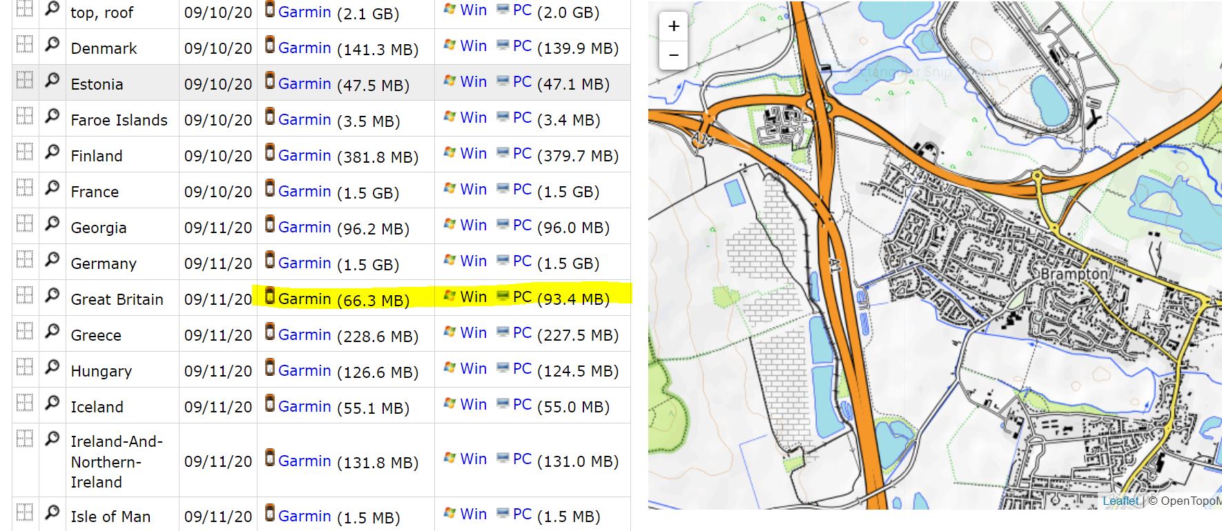
I like the opentopomap's style of map. To get up to date maps on my Garmins i download from opentopo. Recently the Garmin.img file seems to be much smaller than the PC basecamp version and i cannot get it to work. I have got the PC version to display with Basecamp running on a Win10 PC but it won't export the map to my Oregon 650 either. Any ideas please? https://wiki.openstreetmap.org/wiki/OpenTopoMap and http://garmin.opentopomap.org/
|
|
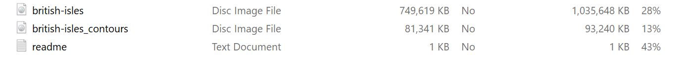
Hi guys, I think it's broken again. Downloaded it yesterday and there is only one IMG file called "great-britain_contours.img" (75.79 MB) inside the ZIP file. The contours (when uploaded to my device - Edge 1000) appear on the list of available maps and they work fine when enabled, but the main topo map is not there obviously. Tried to export the area I need from BBBike and for some reason half of the area shows up as blank white squares (pretty much only half of it shows up OK). Tried exporting OpenTopo and Leisure and has the same issues (slightly different area is blank though). Exported a cycling map (Openfietsmap lite) of a different UK area from BBBike a few weeks ago and works fine. I need the OpenTopo map in a couple of weeks, so will wait and try later to see what is included in the ZIP file. I guess there is no other solution for that. Perhaps there is an error in UK OSM data which prevents it to export to IMG file or something like that. Fingers crossed. BTW. Does someone know if a topographic map from here: https://alternativaslibres.org/en/downloads.php is the same as OpenTopo look? I'm gonna give it a go and see. Cheers everyone. Greg I am sure it will look different to opentopo all styles i have tried in the past do things their way.
(11 Mar '21, 23:21)
andy mackey
|
|
Problem fixed. opentopomap have issued a new download and it now works. The file sizes are now of the size i would expect to see jpeg. thankyou for your help.
If you compare the size of the offered files in the question, you will see the problem. |
|
Hi Andy, The newer basecamp versions 4.7.2 breaks the mapinstall feature to export maps form basecamp to your device. Instead You can download the .IMG Format version from opentopomap en copy it to your device SD card manually. I think basecamp 4.6.2 is the latest version which still works. If I remember correctly, it also has been fixed if you install the mapinstall update package. https://www8.garmin.com/support/download_details.jsp?id=3291 kind regards, Joris Thanks I try your suggestions soon.
(13 Sep '20, 18:22)
andy mackey
|
If you don't need all of the UK, maybe a smaller extract from bbbike might tide you over? They list that style as an option.
I wonder if the failure to send to the device is tied to the failure to generate an appropriately sized composite file?
Thanks I am a walker, but I'll try it. as an alternative I have download Talky Toasters GB.img but it's not as recent as opentopo's offering.