I have a set of locations, the workers need to visit this locations (view below image with points) i need to find the best possible route along this set of points no matter where does it start.
I tried with the "trip/" API but it creates new points that do not exist in the original points, and this creates a terrible route.
Am i missing something in parameters?
http://router.project-osrm.org/trip/v1/driving/-90.499807,38.82392;-90.497916,38.822408;-90.498461,38.822241;-90.496597,38.82351;-90.496352,38.823821;-90.49809,38.825024;-90.495743,38.823304;-90.497415,38.824089;-90.498851,38.823079;-90.49957,38.822156;-90.500771,38.823087;-90.49861,38.82196;-90.496589,38.82255;-90.497906,38.82286;-90.49696,38.822816;-90.49897,38.822577;-90.499736,38.823182;-90.498388,38.823185;-90.498142,38.822603;-90.496481,38.823885;-90.497778,38.824796;-90.497826,38.82337;-90.498705,38.822402;-90.500444,38.822877;-90.497618,38.822596;-90.49804,38.823532;-90.49696,38.822301;-90.499445,38.823499;-90.499071,38.823257;-90.497862,38.823564;-90.496668,38.823013;-90.49884,38.823535;-90.497157,38.822219;-90.49719,38.824389;-90.497107,38.822891;-90.497237,38.822968;-90.499633,38.823079;-90.497061,38.823837;-90.498126,38.823626;-90.497969,38.823923;-90.497473,38.823134;-90.498297,38.825059;-90.499794,38.822598;-90.497592,38.823214;-90.497783,38.82433;-90.498189,38.824087;-90.500557,38.822791;-90.498589,38.82233;-90.498388,38.822737;-90.500666,38.823171;-90.498729,38.823003;-90.497878,38.8249;-90.497381,38.823502;-90.49828,38.8231;-90.497951,38.823454;-90.498483,38.825039;-90.498259,38.822677;-90.499498,38.824195;-90.49817,38.821799;-90.497142,38.823337;-90.498742,38.823433;-90.499237,38.823305;-90.497186,38.823919;-90.499503,38.822995;-90.50002,38.822828;-90.49881,38.822496;-90.500109,38.822332;-90.496935,38.823773;-90.498629,38.822908;-90.500189,38.823052;-90.497524,38.823586;-90.498032,38.822502;-90.499083,38.822658;-90.498594,38.82339;-90.497649,38.824736;-90.49619,38.823234;-90.498351,38.822154;-90.498219,38.822085;-90.499487,38.822238;-90.497439,38.824546;-90.500558,38.823266;-90.498143,38.824573;-90.499182,38.82447;-90.500382,38.822984;-90.496852,38.822382;-90.498783,38.824051;-90.498525,38.823872;-90.496953,38.824221;-90.499716,38.824013;-90.497348,38.822449;-90.499709,38.823049;-90.498075,38.823999;-90.499417,38.822915;-90.500137,38.82364;-90.499989,38.823707;-90.500451,38.823362;-90.499698,38.822076;-90.499604,38.82411;-90.496008,38.823548?steps=true&overview=full
This is the original set of locations 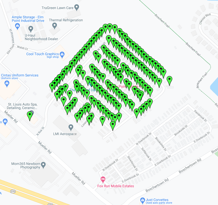
And this is what returns from OSRM, clearly there are additional points, and its wrong 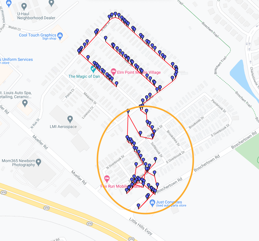
asked 07 Sep '20, 19:06

RonEskinder
16●1●1●3
accept rate: 0%
What are you actually plotting to produce the second view? I swapped the geometry output to geojson and the linestring it produces only shows a path along the expected streets.
"geometry": "ww}kFvujgPGGj@{@
@o@FMFIHKNUFKNWHMDGb@o@Y@iDlFIKSUQSu@_AIIoA{AKQCYDYNUJMDIHKDIXc@FK@m@HMVa@FKPYLSXc@NUHMh@}@PUHCDAL?LFPVv@zA[f@EDQXOV[d@EHOTILSXCDOVCBINOTMROTOVEFe@r@~GsKJR^t@LVP\\@DNVm@~@EFQVQXOTJMzAaCzAxCDJM@KJGJQVABMRQVOTQXt@fALPPVuAqBQXOTq@dAU\\GLCBJQ^f@FFr@~@{AoBFKGJYd@W@GJCTBTHHNR@@LPPTMQm@u@IKu@_AQUe@k@",