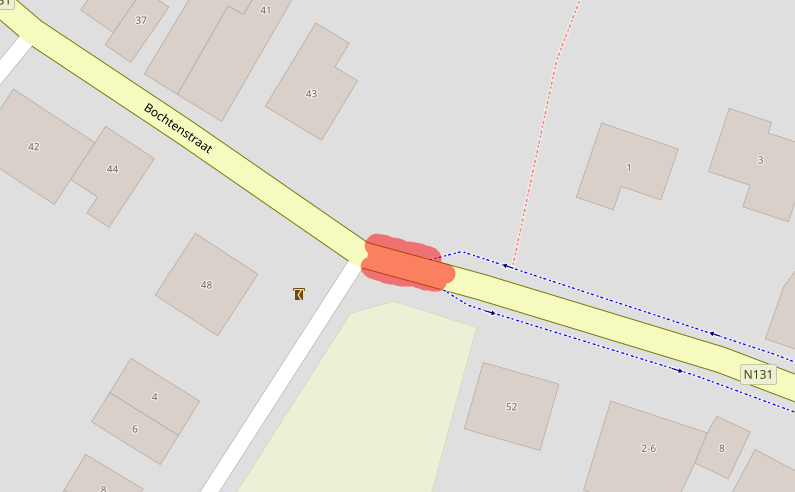
Hoi , zou iemand eens willen kijken naar : Plaats: Rijkevorsel (België) Straat: Bochtenstraat. N51° 20.871’ E4° 45.881’ Als je het dorp uit fietst dan gaat op de opgegeven locatie de weg over naar een fietspad. Het lijkt erop dat de twee fietspaden aan beide kanten van de weg aan mekaar vast zitten en dat je daardoor er niet over kunt navigeren. Ik weet niet hoe ik dit zelf aan zou moeten passen. Wil iemand me even verder helpen ? Alvast bedankt, f.v.opstal@outlook.com asked 10 Aug '20, 10:03 DeN8W8 edited 10 Aug '20, 10:06 |
2 Answers:
Zou hopelijk opgelost moeten zijn (changeset), rode gedeelte stond op bicycle=use_sidepath. answered 12 Aug '20, 22:17 Robin van de... |
Navigation for a car or cycle seems to work. see https://www.openstreetmap.org/directions?engine=graphhopper_car&route=51.34720%2C4.76375%3B51.34662%2C4.76584#map=19/51.34691/4.76479 answered 12 Aug '20, 22:51 andy mackey edited 12 Aug '20, 22:53 |


I have converted your numbers to decimal degrees as used by OSM. https://www.openstreetmap.org/search?query=%2B51.34785%20%20%20%2B4.764683#map=17/51.34752/4.76483 it's easier to zoom into the map and then copy the URL
If that is the precise location, or you can correct it, you will have a better chance of getting an answer.