NOTICE: help.openstreetmap.org is no longer in use from 1st March 2024. Please use the OpenStreetMap Community Forum

buongiorno ,volevo sapere come si può calcolare un tragitto a piedi,ho visto in basso a sinistra la barretta dei km che varia + o - con le dimensioni della mappa ma non sono capace di usare,o non lo trovo ,lo strumento per calcolare la distanza,grazie dell'aiuto.

This question is marked "community wiki".

asked 11 Jul '20, 15:49

Marco's gravatar image

Marco
11112
accept rate: 0%

edited 14 Jul '20, 08:04

scai's gravatar image

scai ♦
33.3k21309459


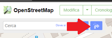
La "barretta" in basso a sinistra indica la scala della mappa. Per calcolare la distanza, puoi impostare un percorso cliccando sul simbolo con due frecce vicino alla barra di ricerca:

alt text

Poi dall'interfaccia che ti si presenta, puoi trascinare i due pin verde e rosso per impostare partenza e arrivo e far calcolare al sistema tempo e distanza.

Ricordati di impostare "A piedi" nel menu a tendina (GraphHopper o OSRM è abbastanza indifferente)

alt text

permanent link

answered 11 Jul '20, 19:16

Mannivu's gravatar image

Mannivu
1.1k31027
accept rate: 6%

Follow this question

By Email:

Once you sign in you will be able to subscribe for any updates here

By RSS:

Answers

Answers and Comments

Markdown Basics

  • *italic* or _italic_
  • **bold** or __bold__
  • link:[text](http://url.com/ "title")
  • image?![alt text](/path/img.jpg "title")
  • numbered list: 1. Foo 2. Bar
  • to add a line break simply add two spaces to where you would like the new line to be.
  • basic HTML tags are also supported

Question tags:

×26
×1
×1
×1

question asked: 11 Jul '20, 15:49

question was seen: 2,469 times

last updated: 14 Jul '20, 08:04

NOTICE: help.openstreetmap.org is no longer in use from 1st March 2024. Please use the OpenStreetMap Community Forum