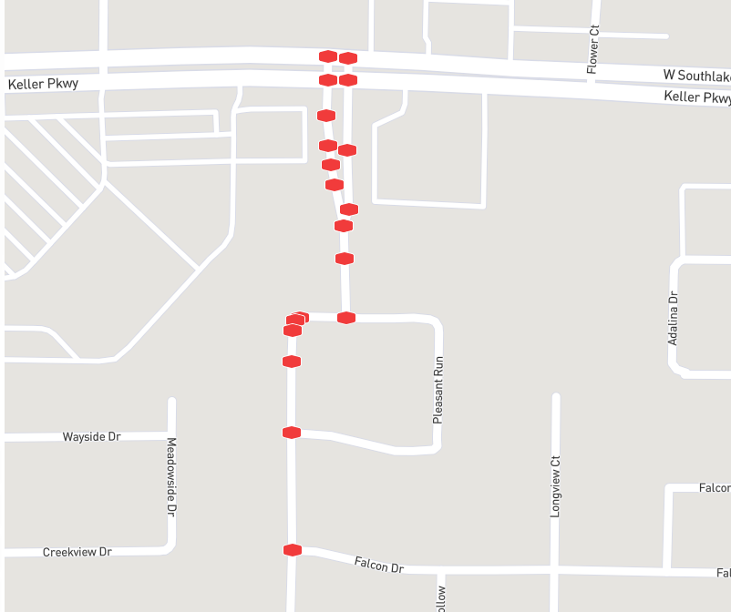
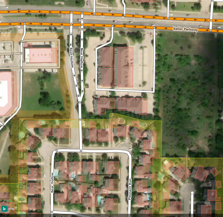
If a road (side street) enters a divided road, i.e. with a median, where is the end of the side street? Does it end when it meets the divided road, or does it end on the other side, crossing the divided road? Note: The side street does not continue on the other side of the divided road, it ends when it intersects the divided road, i.e. a driver must turn right or left. If you are interested in the background of this question, it is this: I recently discovered the site CityStrides. Through the use of a GPS enabled device, and either the Strava app, the MapMyFitness app, or the RunKeeper app, CityStrides keeps track of how many streets (in OSM) you have traversed, on foot. This last part is important, as CS uses GPS to determine if you pass a "node" (in OSM speak this is a "point" on a road). If that point is on the other side of a divided road, then one must, potentially, cross the road to "pick up" the node. If the road (side street) does not continue, then one has little reason to cross the road, save to pick up the node. One caveat to this: That node, on the other side, will eventually need to be picked up to complete the divided road, but if that divided road is log, that could take some time. And one must traverse the road in both directions, to get all the noes. I contend it would be advantageous, from a Strider's point of view, to have the side street end on the near side. This allows for the road to be completed sooner, versus later. One must collect 90% of a road's nodes to get credit for completing the road. In the case of short roads, or roads with less than 9 nodes, this means one must collect all nodes to get credit. But, I don't want to break OSM convention for the sake of picking up a node. Actually, this will make it easier for future Striders, as I've likely already crossed the road. :-) Thank you for reading, and for your opinions. Sincerely, Eric PS. When tagging, I added "nodes" and see this is an oft used tag. I'll have to look into that useage here. [EDIT] Getting better here. After the first response, I realized a picture or two just might be worth a thousand words, or two. In the first image, you can see the red nodes on a CS map, and they correspond to points on the OSM map, below. Had I been to these nodes, CS would display them in green. Note that Bear Hollow "ends" on the north side of Keller Pkwy (in OSM). I would not be able to complete Bear Hollow, without crossing Keller Pkwy. If Bear Hollow "ended" on the south side of Keller Pkwy, I could. I don't know the algorithm employed by CS, but it seems to be pretty good. On wide, divided, roads, if I run/walk one side, I will only collect those nodes on the side I traversed. I might go this Bear Hollow and just do one side to see what happens if I just traverse one side. So, what is more proper by OXM standards, for Bear Hollow to terminate at the east bound lanes, or west bound, of Keller Pkwy?
asked 07 Apr '20, 14:27 EricJRW edited 08 Apr '20, 03:09 |
One Answer:
In OSM the vast majority of roads are line features, i.e. only the center line is mapped. Road width and hence sides are only determined by the renderer based on road classification or theoretically on the width if it is tagged. So from OSM point of view the answer to your question is: at the intersection of the center lines. The question is a bit theoretical anyway. As I understand your explanation CityStrides wants to determine where you have already walked/run based on GPS. Now consumer grade GPS is quite inaccurate especially in a city with buildings reflecting the GPS signals. You see the zigzagging of a GPS track when you overlay it on a map. So any algorithm that wants to determine what road you are on has to take that into account and do some smoothing and guessing. I don't think there is much room for distinguishing between this and the far side of the intersection. But in the end I guess you have to ask this question to CityStrides. answered 07 Apr '20, 15:14 TZorn |
@tzorn - I've edited my original question to include pictures. I should have done this the first time. Hopefully it helps. This was my first post/question here. Thank you, Eric
Thanks. I did not understand your meaning of "divided road" correctly. I would refer to such road as a dual carriageway, but I'm not a native English speaker.
That said, I'm not sure I understand your question entirely. Of course roads need to be connected so that a router is able to guide traffic along the road. Bear Hollow needs to continue all the way to the north side of Keller Pkway, otherwise a router or a person looking at a map would not know if you can turn from Bear Hollow into Keller or not.
What CS does with that information is a completely different kettle of fish. In no way should we as OSOM mappers try to accommodate CS rules but CS needs to take OSM information and interpret it in a suitable way.
"In no way should we as OSOM mappers try to accommodate CS rules but CS needs to take OSM information and interpret it in a suitable way." Thank you, this is the exact answer I was looking for. Do what conforms to OSM rules. Many users of the data, so data must be entered in a consistent way. The developer at CS does get very creative in interpreting OSM data to accomplish his task. Reading his posts is very enlightening. Well thank you again, Eric