asked 18 Jan '20, 14:03 red_o_sun |
4 Answers:
All of the solutions seem to be -very- complicated compared to simply using https://wambachers-osm.website/boundaries/ answered 19 Feb '20, 09:32 SimonPoole ♦ |
Hi, You could test with http://overpass-turbo.eu/, using wizard tool to build your request. For instance, for your first point "1.Get the whole china country boundary with province level (a whole country boudary line and province lines)", you could use these expressions for wizard:
You may have to increase default timeout (25). You can try QuickOSM in QGIS to get it in shapefile, or import your overpass json result in QGIS to convert it. You can also try to download your data from http://download.geofabrik.de/asia/china.html directly in shapefile and filter it later (but the shapefile is really big for China). To know which admin_level to use to request data, have a look at Wiki OSM - Tag:boundary=administrative (see China entry in the table) Good luck ! Augustin answered 18 Jan '20, 21:16 augustind edited 18 Jan '20, 21:18 Hi,augustind: emm; but i need detail code like this to run in wizard tool(but it always failed to run ): So maybe i need a code that really come to run successfully ; thanks (19 Jan '20, 03:44) red_o_sun |
Maybe
Below requests works for me.
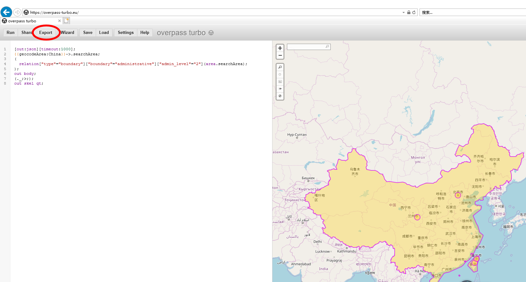
You could be able to union these requests to get results in one shot answered 19 Jan '20, 10:09 augustind edited 19 Jan '20, 10:12 Hi,augustind: Is this my network problem? thanks (20 Jan '20, 03:23) red_o_sun I don't understand what you mean by (20 Jan '20, 13:18) augustind Oh, that's a picture can not work; Hi,augustind: Some times it can be work normally ,and show the boundary in map; How do i download the "map" data query from the website:https://overpass-turbo.eu/ Thanks (21 Jan '20, 08:31) red_o_sun Hi, here is some doc: https://wiki.openstreetmap.org/wiki/Overpass_turbo#Exporting_Results (21 Jan '20, 11:04) augustind Hi,augustind: it's really a problem for me to use the website ; the export button can not work at all. so follow your advice : download your data from http://download.geofabrik.de/asia/china.html directly in shapefile and filter it later (but the shapefile is really big for China). year ,it's really a big file to import to QGIS tool. this file contains so many lines or builds polygeon... so if i just only want to filter all the area ,how do i do? it means i only want to filter the level of boudary like changed the : ["admin_level"="4"] to ["admin_level"="6"] or ["admin_level"="8"] how do i do ? Thanks (22 Jan '20, 07:21) red_o_sun Hi, You say "it's really a problem for me to use the website ; the export button can not work at all.": what is your web browser ? maybe try another one ? (22 Jan '20, 20:41) augustind Hi,augustind: Long time no see coz china serious Novel Coronavirus Pneumonia. i has tried chrome ,IE,firefox ,all of them the button "export" can not work (19 Feb '20, 09:25) red_o_sun i upload the pic for this @augustind (19 Feb '20, 09:48) red_o_sun and i want to get the boudary lat/lon as format xxx.geojson file;@auguistind (19 Feb '20, 09:52) red_o_sun Hi,augustind , can you help to check it why ?or can help to download the boudaries for me ? thanks (05 Mar '20, 09:11) red_o_sun showing 5 of 10 show 5 more comments |
answered 19 Feb '20, 09:48 red_o_sun |
thanks i ll tried this; @Simon
Hi,Simon:
Hi,Simon: i tried to download all boundaries i need ,then it notice me: "Too many boundaries selected. Please use the CLI with parameters like &from_al, &to_al and &exportLayout. For help press Info/Help button."