Hello: There is a large military base near my rental property. For some reason, a small section of that base is shown on the map as a different background color than the rest of the base. That different background color makes it look like that section is a runway for an airport (there is no airport anywhere nearby) and I get perspective renters hesitant to rent from me thinking there will be airplane noise. How do I change that background color to the same color of the surrounding area? Thanks asked 14 Jan '20, 22:23 AA1667 |
One Answer:
You can try to change it yourself. If you are at www.openstreetmap.org zoom onto the problematic location and hit the "edit" button on the top left. You need to register an account, though. Click on the offending feature (a closed line) and have a look at the left hand panel what it is supposed to be. It could also be that there is nothing and your "runway" is just blank background between other mapped features. If you find there is something wrong you can try to change it on the left panels by assigning or creating a different feature or by extending other already mapped features to the location. Note though, that we don't "change the displayed background color" but we map real world object and describe what they are. The producer of the map (and there are many different ones out there) decide on how to render the object on the map. Before you actually change something follow the tutorial in the editor window and have a look at https://learnosm.org. If you are unsure come back here and post a link of the location so that others can have a look. answered 15 Jan '20, 11:47 TZorn edited 17 Jan '20, 08:30 I have tried to change the background color but it requires me to zoom in and then the color goes away. I can’t find any boarders that are creating the shaded area. Here is a link to the location. https://www.openstreetmap.org/#map=14/47.1158/-122.5298 It is the shaded area that is centered around Rainier Drive. Please either let me know how to remove the shaded area that is arbitrary and is not actually indicating anything that exists or if you prefer, you can just do remove it. Thank you (16 Jan '20, 21:48) AA1667 1 I don't see anything out of the ordinary there, nor anything resembling a runway. But you have made some changes already. So maybe your browser is just still showing outdated map tiles. Try relaoding the page from the server (ctrl + F5 in some broswers). I notice you changed the name of a place from American Lake Garden Trakt to Woodbrook. When doing so you also removed the tag place=hamlet which was the defining main tag of this object. Without it the node doesn't have any useful meaning anymore. Please go back to the editor, select the node in question and in the left hand panel make it a hamlet again or some other appropriate type of place as described in our wiki. (16 Jan '20, 22:22) TZorn
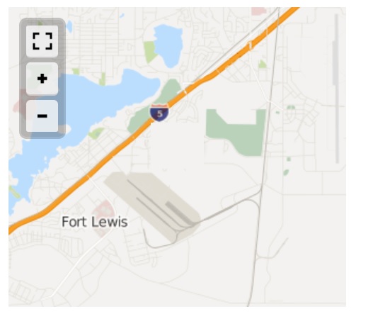
I have tried replace the "hamlet" tag with "neighborhood" but have been unable to figure that out, so I just deleted the node. Here is a screen shot of how that area that appears to be runways because of its shading and the way the streets are laid out. Please remove the shading or let me know how to do it. Thank you for your help. (16 Jan '20, 23:19) AA1667 Are you talking about the railway yard / Fort Lewis Logistics center industrial area you deleted? It takes time before a change like this is applied in zooms 1-12. So you don't see the area anymore in 13 or 14, but still in <=12. And you still see the "Fort Lewis Logistics Center" labelling there. Same applies for external map providers like the one you "screenshot"ted. But I'm not so sure if deleting an industrial area (and that's what that yard area is) because of someone misinterpreting it as an airport is a good idea... (16 Jan '20, 23:48) Spiekerooger 1 @AA1667 please don't just delete features because you cannot figure out how to do things. I reverted your deletion and changed the node to a neighbourhood as per your comments. But please also have a look at that industrial area again. Is it part of the military area? Do you have to pass the military area gates to get there? And you just deleted the name, why? A web search suggests it is the Logistics Readiness Center. Then by all means name it like that. (17 Jan '20, 08:28) TZorn |
If you can provide a link to the location, it will help people diagnose the issue.