I'm trying to draw a separated two-way cycle track that is attached to a main road (separated by bollards, very clearly marked). The wiki suggests two ways of doing this: Either I use The wiki mentions:
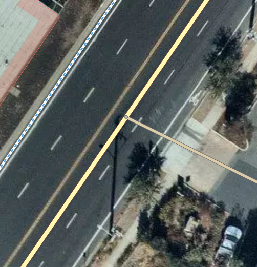
This makes sense, but I'm not 100% sure what the exact way to do this is: should we be adding extra cycle tracks to connect with features, or should we extend features to hit the cycle tracks? If I have the following situation, I have two ways of connecting the cycle track (top left) to the parking aisle (bottom right). I can either extend the parking aisle route further across the road (yellow diagonal) to connect with the track, or I can draw a tiny branch off the cycle track that meets at the junction. It seems like the former is the better option, but I'm not sure. (Note: the satellite imagery here hasn't been updated to show the cycle track, but it's where the old cycle lane used to be)
asked 25 Nov '19, 04:50 Manishearth |
2 Answers:
Personally I would usually extend the parking aisle to the cycle track if there were a suitable dropped curb etc. for the bikes to drive over. There has been a recent proposal for answered 25 Nov '19, 07:59 InsertUser |
I disagree with InsertUser here, albeit in details rather than in principle. I would connect the service road to the main road, BUT NOT to the cycleway. Instead I would create a short cycleway from the main cycleway to join the service road where it intersects the service road. These would be rather equivalent to the footway=link suggestion as InsertUser remarks. The reason for doing it this way are: you cant drive from the service road onto the cycleway; it doesn't require lots of additional access tags; and (co-incidentally) it happens to render more cleanly. Equivalent constructions are quite common with footpaths in estates with many short service roads. answered 25 Nov '19, 16:58 SK53 ♦ Won't it render the cycleway as having a lot of little "hairs" on maps? (25 Nov '19, 17:18) Manishearth 2 @Manishearth: you shouldn't care about the rendering, but about the correctness of the data, for the reason SK53 gives: "you cannot dive from the service road onto the cycleway" (26 Nov '19, 04:05) escada 2 @Manishearth: in practice the road will be rendered over the cycleway so that at most zoom levels it will be either totally obscured or barely visible. If the footway=link suggestion is adopted then renders could, in the future, choose not to render such ways. (26 Nov '19, 10:58) SK53 ♦ If the bollards mentioned in the question were mapped on the side road then they wouldn't be passable by cars either. (26 Nov '19, 21:26) InsertUser |
Thanks! We should probably mention this in the wiki somehow if it's the most common way to do things.
I don't know whether it's truly the most common. I tend to think of it as the simplest way that isn't 'wrong', similar to extending the service road through a dual carriageway rather than stopping at the first lane and transitioning into
primary_link.AFAIK, In the country where I map, this would be changed to the way SK53 describes