NOTICE: help.openstreetmap.org is no longer in use from 1st March 2024. Please use the OpenStreetMap Community Forum

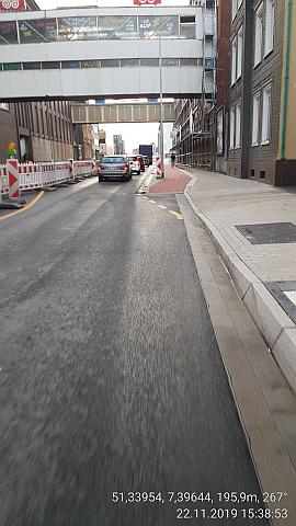
The figure of tunnel=building_passage is incorrect in the map, see foto.alt text [map=19/51.33938/7.39570]2 Fabrik Brandt, street level=0 How to map?

asked 23 Nov '19, 07:53

NorbertOpen's gravatar image

NorbertOpen
54151618
accept rate: 0%

edited 23 Nov '19, 09:57

TZorn's gravatar image

TZorn
12.3k764225

Can you explain what do you mean by the figure is incorrect?

(23 Nov '19, 09:03) Kovoschiz

covered=yes and tunnel=building_passage should be removed from the ground level street. The building parts that extend over the street are already tagged fine.

See also a related recent question for some further reading.

But there is also something else fishy on the road. It says oneway=-1 but it has forward and backward lanes and bus routes in both directions which doesn't really make sense.

permanent link

answered 23 Nov '19, 09:56

TZorn's gravatar image

TZorn
12.3k764225
accept rate: 15%

edited 23 Nov '19, 09:59

Follow this question

By Email:

Once you sign in you will be able to subscribe for any updates here

By RSS:

Answers

Answers and Comments

Markdown Basics

  • *italic* or _italic_
  • **bold** or __bold__
  • link:[text](http://url.com/ "title")
  • image?![alt text](/path/img.jpg "title")
  • numbered list: 1. Foo 2. Bar
  • to add a line break simply add two spaces to where you would like the new line to be.
  • basic HTML tags are also supported

Question tags:

×27
×21
×5

question asked: 23 Nov '19, 07:53

question was seen: 1,055 times

last updated: 23 Nov '19, 09:59

NOTICE: help.openstreetmap.org is no longer in use from 1st March 2024. Please use the OpenStreetMap Community Forum