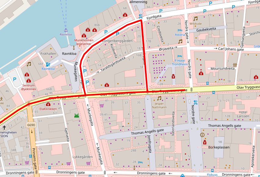
I have a GPS trace of a route used by a vehicle. I am trying to find out whether this path is the same as estimated/propose by OSM. But GPS trace is missing some points, so it forms a straight line between two points(line goes over through some places on map instead of following a road). My solution to this was using a Match service provided by OSRM. It works fine but sometimes it generates a loop over some routes (keeps on circling the same route near a roundabout), when it should have gone straight. How I can solve this issue.
I used following request to local server and extracted the generated poly-line and then used that to plot this map using folium asked 05 Oct '19, 14:10 vsaadnet edited 09 Oct '19, 09:19 |
This is a static archive of our old OpenStreetMap Help Site.
Please post any new questions and answers at community.osm.org.
For Info. GPX points are recorded at intervals, which you see if you open one with a text editor you will see the positions and their times. If one point is just before a bend in road and the next one or two seconds later is around this bend the line will be straight between the points. Some Sat Navs lock to road so that the display does not look incorrect.
@andy mackey, this is not the problem here, missing points are not just bends apart there are literally a mile apart. Concerned dept. told us that sometimes GPS is not functioning at various locations, so, we have to use match o snap to road api's to visualize the path taken.
Maybe the GPS tracking device is not set to record at short time intervals. The GPS may not be good enough to do the job required or it's signal is degraded by high buildings or even degraded by radio interference, either by accident or design. such as this article https://www.theguardian.com/technology/2013/feb/13/gps-jammers-uk-roads-risks
@andy mackey, problem is not that gps device is missing its about Matching a GPS trace properly using OSM/OSRM. API calls are returning duplicate data.
Could you edit your question and upload a jpeg showing the problem?