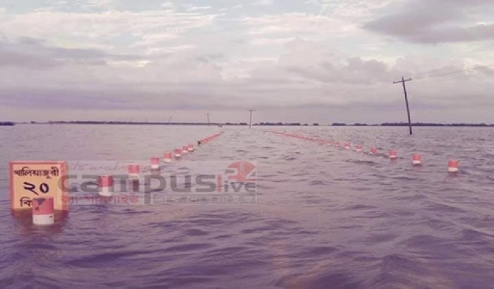
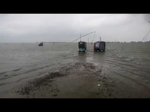
How to tag portion of road which goes under water in rainy seasonThis portion of the road goes under water in rainy season. The road runs through vast area of farm lands which go under water in rainy season, the nature of these lands are like this in rainy season, and remain for 4-5 months. not finding the english word to describe, but in my language these lands called haor (pronounced like haa-oor). Now the question is , how to tag this road portion? ford=yes or flood prone=yes, or other way. Is there any way to set time range to this, like from June - October, this road portion goes under water? editThis road goes under water fully from june-september. village people still walk making their legs wet. In the full active rainy season, it is like above photos. before and after this 'full season', about 1+1 month, vehicles can run but the road acts something like ford ,like the picture aside: https://wiki.openstreetmap.org/wiki/File:Ogle_County_IL_White_Pines_State_Park_Fords3.jpg . video when it acts something like ford: https://www.youtube.com/watch?v=hAqx0vJMmc0
Photos
Video
asked 02 Aug '19, 23:50 zabir edited 11 Aug '19, 07:09 |


One Answer:
There is a wiki page for seasonal tagging of waterways etc., but I'm not sure how often they are used on roads. Time based conditional restrictions on roads do tend to follow the opening hours format which does support months of the year. Whether this is useful in your case will likely depend on how reliable the start and end of the rainy season is. answered 03 Aug '19, 19:57 InsertUser |
Thanks. seasonal tagging solved another question about seasonal wetland which I was going to ask here. I think this would work for roads too. where it works for wetlands, ponds, grocer's/farmer's markets, waterways.
I've added both
seasonal=wet_seasonandflood_prone_yesand removedford=yeswhich is inappropriate I think.Here's an example of conditional tagging on a road usually closed in winter: https://www.openstreetmap.org/way/127867704.
did you place seasonal=wet_season on the highway ? Wouldn't that mean it is usable during that season ?
sorry for late. I was busy for Eid Festival.
@escada I thought 'flood_prone=seasonal + seasonal=wet_season' make it flood prone in wet season.
@SK53. thanks. that helps. This road goes under water fully from june-september. village people still walk making their legs wet, still I would set it not accessible. In the full rainy season, it is like above photos. before and after this 'full season', about 1+1 month vehicles can run but the road acts something like ford ,like the picture aside: https://wiki.openstreetmap.org/wiki/File:Ogle_County_IL_White_Pines_State_Park_Fords3.jpg .