I have OS coordinates that I want to display with a small marker in open street map. Is this possible? asked 12 Jul '19, 15:59 Vic showing 5 of 11 show 6 more comments |
3 Answers:
While Andy's method works for a single marker it's still a clumsy method. The reality is openstreetmap.org is not designed for such things. You should turn to another OSM based service. uMap for example can display markers in different ways on top of a multitude of all sorts of map backgrounds. answered 13 Jul '19, 07:36 TZorn I couldn't get uMap do Ordnance Survey co-ords? but maybe the other tools may be a little easier once you have lat lon. I find a few clicks with OSM gives me a link and marker, this took 20 seconds https://www.openstreetmap.org/?mlat=52.32184&mlon=-0.18862#map=17/52.32184/-0.18862 , it's just describing it takes much longer. (13 Jul '19, 08:21) andy mackey |
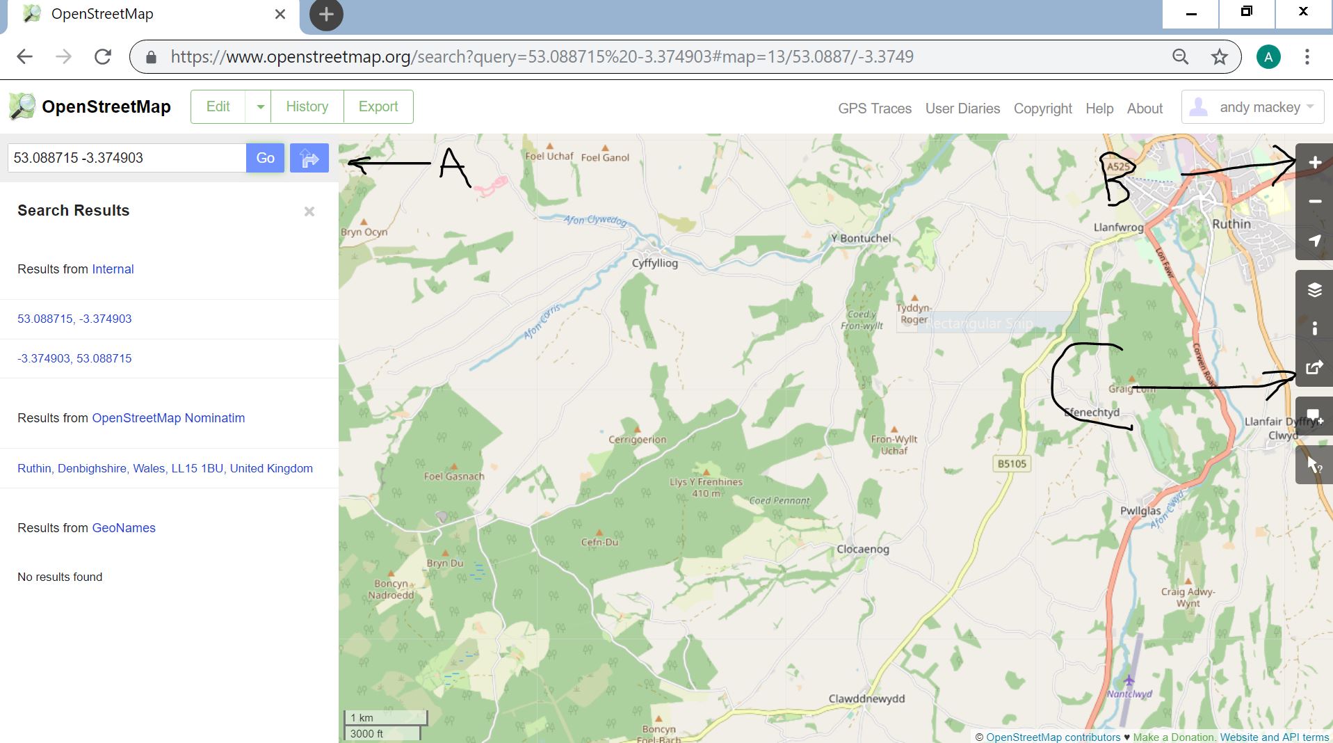
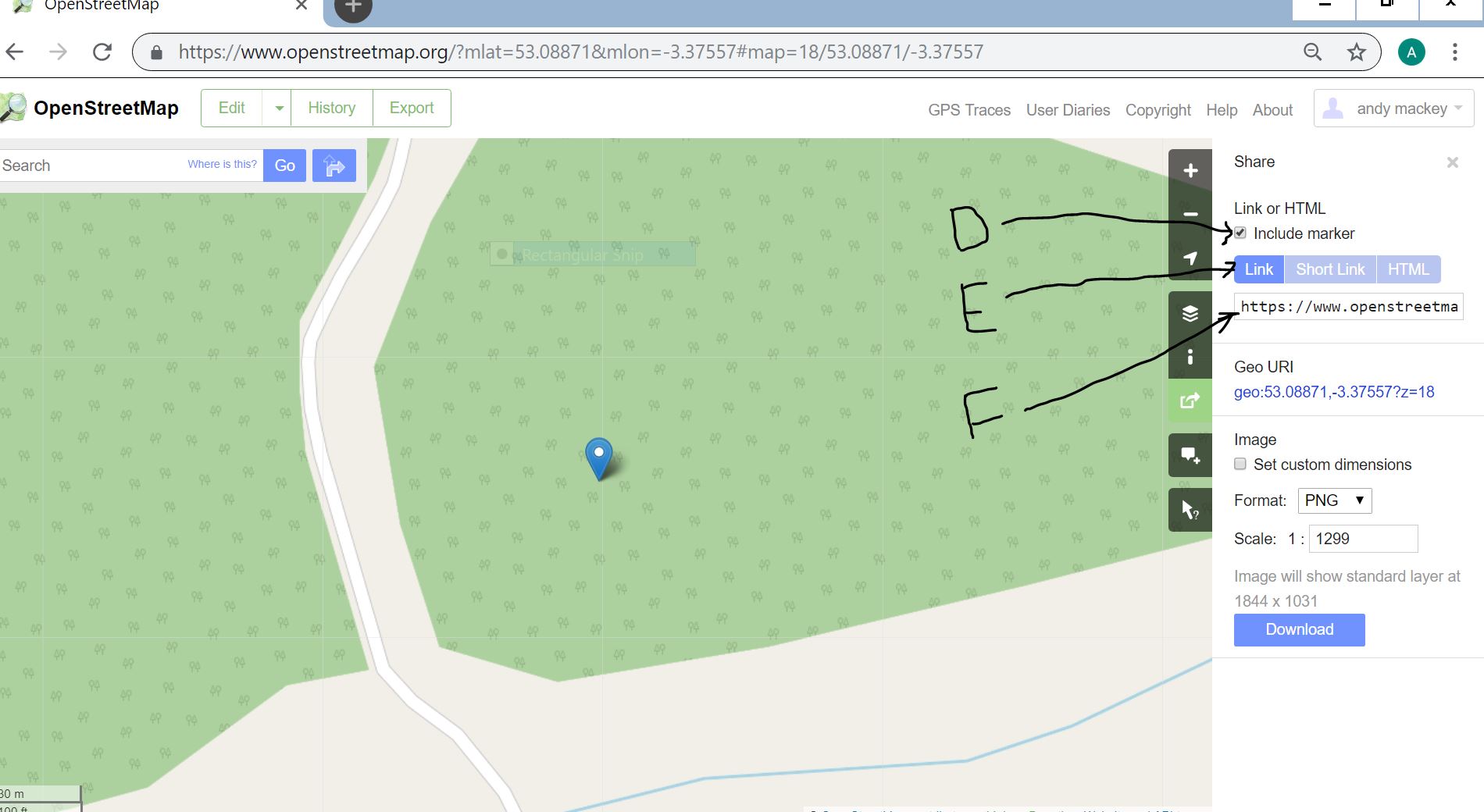
Try this http://www.nearby.org.uk/conversions.cgi for the conversion, put the lat lon into osm search box, better if you zoom in first, share and add a marker and you get this https://www.openstreetmap.org/?mlat=53.08871&mlon=-3.37557#map=18/53.08871/-3.37557 Put the co-ords into the search box A. Zoom in by clicking on B + . "Go" on search ( if you don't do zoom first you wont know where the middle is. Use C to share.Add a marker tic box D. Click on E. Then cut and paste link at F. that's how i generated the map with the marker. This one https://www.openstreetmap.org/?mlat=53.08871&mlon=-3.37557#map=18/53.08871/-3.37557 I sounds much more complicated than it is. Easy to try out and not a problem if it goes wrong, I email links to myself to test them.
answered 12 Jul '19, 20:57 andy mackey edited 15 Jul '19, 11:52 |
Guessing a bit about what you're trying to do here, but if you want to do offline conversation of OSGB to lat/long then some of the links from here might be helpful. The detail in that forum thread is probably just telling you what you already know (that it's complicated!), but some of the links there might be helpful to go with some of the links in other answers. answered 13 Jul '19, 11:35 SomeoneElse ♦ |
Just to make sure, "OS" in this context is the British Ordnance Survey?
Ye,s British Ordnance Survey eg SJ 0801655495
Sorry left the space out
Thank you for your reply Andy. I don't have a problem with converting the coordinates but I cannot find how to display them in OSM with, if possible, a label.
Thank you for your replies. I tend to agree with TZorn, it's possible but not quick or easy for multiple points and no labels.
A supplementary question, When you "Share" does that mean that the point is in the public domain?
I don't think it's public. You choose who to share a marker on a map by email or other communication. I use it to share a start point of a walk with friends
Vic for route planning i use a couple of excellent Ramblers Group websites, they have mapping and GPS tools. Try https://nmc-ramblers.org.uk/ and http://www.carmarthenramblers.org.uk/useful-links.html
Thanks for your help Andy, I'm plotting forestry points rather than routes. It's all a big learning curve!
No I think the difference in terminology is mainly because that bit of the osm.org website was written by an American rather than someone who speaks British English natively. It's just a link.
One other thing perhaps worth mentioning is that if you can provide a bit more detail about what you're trying to do (is this something you want to do lots of times or just once? Automatically or manually? With lines as well as with points?) then people will be able to provide better answers.
Hi SomeoneElse, fair comment, I'll expand a bit. I'm plotting forestry use, the coordinate used as illustration is where rubbish has been dumped. I want to be able to plot various uses over time so it will be frequently done on differing collections of data. I can quite easily do what I want in google earth but as earth is the only thing pertaining to google I still use I want to be rid of it.
Vic how did you get a 10 figure OS map ref? did you use a GPS or smartphone. If so why not set it to Lat Lon Degrees.degrees ( decimal degrees) that can be used directly with openstreetmap, or sent to others to use.