|
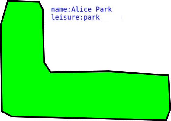
There's a park that's also a forest. I tagged the area with both Leisure:Park & Landuse:Forest. However, there's a smaller section within the park that isn't forested. How do I use a relation polygon to disable just the Landuse:Forest tag for that area? And if that can't be done with relations, what is the recommended way to do it? This is the polygon I'm having trouble with (I think I may have done it wrong): Visual explanation: |

|
It seems like a legitimate solution in this case. Now you just need to move park tag for the whole area (not for multipolygon): 1
I think what you're saying here is that the outer way should have the leisure and name tags as they apply to the whole area, then the multipolygon relation have only the landuse and type tags (but the same outer and inner members) as it is only the forest that has the hole. If so I'd agree.
(13 Nov '18, 16:19)
EdLoach ♦
3
Concur that the park tag can go on the outer way and that a multipolygon with an inner will exclude the area without trees. However I am in the camp that landuse=forest implies trees grown for producing wood products which seems unlikely for a park. I usually double tag with natural=wood and my preferred (but not supported by the renderer at www.openstreetmap.org) landcover=trees. See, among other parts of the wiki https://wiki.openstreetmap.org/wiki/Forest I prefer landcover as I can see there are trees but don't know if they are there "naturally" or if they are being managed for harvesting for wood products.
(13 Nov '18, 17:16)
n76
Disregard my previous message in case it's in your inbox - I've figured it out. I figured out how to follow your directions and have accomplished what I wanted to do. My misunderstanding was that I wasn't aware that the outer way and multipolygon relation were separate things that can have attributes tagged to them individually.
(21 Nov '18, 20:00)
Cambroulet
|
|
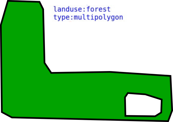
What you have there are really two areas:
So you draw a park:
This only requires a closed way that carries the park's tags, i.e. And you draw a forest:
Because it has a hole, we need to use a multipolygon relation. So it consists of two closed ways (the outer ring and the inner ring), plus the relation that holds them together and gives them meaning. The forest's tags (i.e. That's it. There's one more thing that may be causing confusion here, though: The way we've drawn for the park, and the way we've drawn as the outer ring of the forest, have the exact same shape. This isn't necessarily always the case, as you could easily imagine a park where there's some grassy area without trees at the edge. But in our example, it is. So to save effort while creating and maintaining this kind of data, mappers will usually choose to re-use the park way as the outer ring of the multipolygon relation instead of drawing a second way with the same shape. Doing that is allowed and common practice. But note that this does not have any special meaning compared to creating a second way. It's purely for convenience. |