When we check statistics of roles in all relations of a country (Planet dump), we see a big diversity of roles... And some of them not make sense. There are a list of valid roles? We can change by Overpass (mass edition) the invalid ones? Example of Brazilian roles of (visible) relations that are members of relations: Example of Brazilian roles of (visible) ways that are members of relations: All are valid? " asked 02 Nov '18, 16:35 ppKrauss edited 03 Nov '18, 12:19 |
2 Answers:
You can look at the OpenStreetMap wiki to find out documented features, and see some common relations. Also TagInfo can help you to see which relations and tag combinations are common. As for the other less-known or undocumented tags to describe, they are just that. They are not necessarily wrong. Although sometimes there might be typo, the others were added because the mapper(s) though that was the best way to describe the feature. There is no reason to remove or alter them on a large scale. You could ask each mapper to document them, or discuss with them whether there is a documented way to express the same, etc. But you will probably find this too time consuming. So my advice is, to just ignore the values you are not intested in. Marc Zoutendijk wrote a series of diary posts called "Improving the OSM map - why don’t we" on exactly those 1 off tags you find everywhere. Don't forget to read the comments, to find out other mappers ideas about this "problem". answered 03 Nov '18, 06:46 escada Hi @escada, thanks all explanations! Is important to see, from experient mapper as you, an assertion "just ignore the values you are not interested in": confirming the "full free/no control" hypothesis for relation-roles... But what Wiki say as "free format text field" is not the same as "free semantic". So, you also showed the spirit of the thing (good links!). (03 Nov '18, 08:23) ppKrauss My only residual doubt is about specialized documentation (for role-values not for usual tag-values), can I start/complement something at Relation#Roles Wiki using your answer? There are something (you see?) with specialized comments about relation-role-values, that I can cite there? ... Or something about consistency between role-values and the tags of the pointed element? (03 Nov '18, 08:24) ppKrauss ... Perhaps the main documentation is to consolidate in one place a summary of all reccomendations: a typical exception to the rule of thumb (full free/no control) is the explicit instruction for islands. (03 Nov '18, 12:39) ppKrauss Everybody is free to write wiki pages. Those pages (if not in your private space), are a community effort. So others might change and or discuss the content of what you write. (04 Nov '18, 06:38) escada |
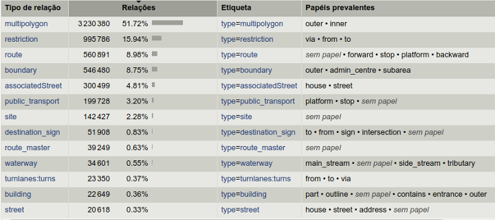
For Portuguese readers... A principal fonte de documentação parece ser a estatística de uso, e isso inclui a correlação entre a tag type do elemento apontado e a role utilizada, conforme destacado na ilustração abaixo ("sem papel" indica uso frequente de role vazia).
answered 03 Nov '18, 09:14 ppKrauss |
What is "valid" for you?
Where do you want to "change by Overpass (mass edition)"? In the main, public OSM database or in your copy?
Hi @aseerel4c26, item 1: "valid" is not "so free", is something that make sense -- like inner and outer that are about topolody, an real information for map construction... I am looking for a standard/recommendation or good practice. Perhaps we can check a country like German and use it as reference model.
About item 2 (of @aseerel4c26's comment), let's wait the answer to make decisions... Cited Overpass only to show possible impact, when we suppose "full free".