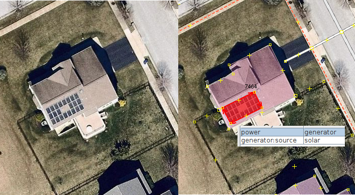
I would like to start adding solar panels in my neighborhood. Many houses around me have simple photovoltaic panels on the roof of their houses. These aren't power plants, just personal power generators. What is the best practice to tagging solar panels on building's roofs? I was thinking to draw the outline of the solar panels and tag it as a generator.
asked 09 Oct '18, 03:32 Kayla Colflesh edited 09 Oct '18, 03:33 |
2 Answers:
Sounds fine. Additionally you can add If you know whether these solar panels are used for producing electricity or hot water you can also either add answered 09 Oct '18, 08:25 scai ♦ |
Don't you think it's personnal / private data ? I wonder if we should map these photovoltaic generators. I would love to but notre sûre if it's a good idea ... answered 27 Apr '19, 15:22 mawy33 2 If the info is being added from aerial imagery or from what is visible in surveys on the public street, then it must be just as non-personal as the outline of a building, surely? (27 Apr '19, 15:31) mcld Hi scai, is not there some thickness visible measurement on those panels. The termal ones are thicker due to the structure inside. A local survey would show it clearly. (28 Apr '19, 14:52) Hendrikklaas |
Some of us have changed over from
generator:place=roofto the more conventionallocation=roof. More info on this wiki page: https://wiki.openstreetmap.org/wiki/Renewable_energy_in_the_United_Kingdom/Rooftop_Solar_PV@scai In most cases I think it's possible to tell them apart. Thermal installations are usually smaller, and darker on imagery. They may also be older and therefore detectable by comparing imagery layers. With good imagery or a ground survey one may detect piping connecting to the internal water system. Solar PV are usually larger arrays of fixed size modules, modern ones being recognisable by a pale surround in imagery. Some examples in my recent blog post: https://sk53-osm.blogspot.com/2019/03/mapping-roof-top-solar-panels.html. I have since collected many more ground level images of Solar PV & will be posting those soon.
@SK53 Thanks for your explanations :)