It really breaks me. It took so many hours to edit this area, I lived here 15+ years. Still I go there, cause it is my hometown, And my home is there. This area was not rich in map, still not, just had buildings roads marked, and nothing happened here for many days, no one came. then I added some features, updated infos. planning to add more. I know this area like my own hand. Now after years, seeing some POIs, someone (found two), deleting the same POI, Building, and re-creating same POI, buildings, sometimes with less data or mistakes. Now reviewing one by one is time consuming, while my Exam is running now. see two months ago history. fortunately I have the older j osm files which I've compared with current. I think they are doing these for credits, points. Like to show the number of edits they have done. This isn't ok. Deleting someones object, then creating the same just for credit. I messaged one guy: "
You are welcomed to edit any area and update information if you really can add something more, or increase the quality. But please, try to keep the older objects. " There are numerous examples, more than thousand as filtered in JOSM . but just pointing some:
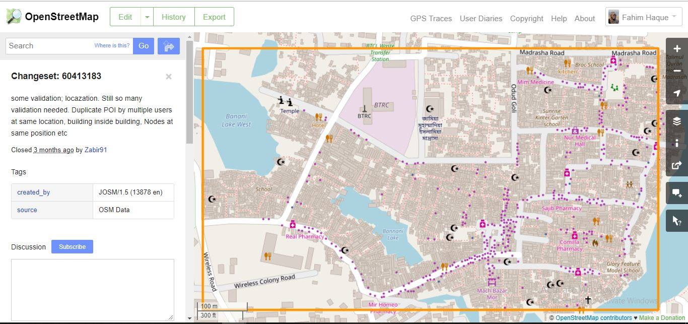
older: changeset/60118816 , Don't know in which changeset it was gone.
my old: /changeset/60118816, New: /changeset/62189156
There are many more. If anyone need the older osm files for comparison. Just comment. I don’t know what some people really want. If they really want credit, and to show the number of edits besides their profile, I’ve no problem. Those are nothing but some virtual numbers to me. I wouldn’t edit those where they have replaced objects with proper info, ok you need credit, keep it. but my problem is, many places, they have removed the infos, just placed the name, and with wrong info. It took me huge time to add infos. I had huge free time that moment and I spent all on it cause I found it fun and planning to enrich it, planning to buy some goods for hiking. But if this happens, then It is just waste of time. I could increase my number of edits by this way{what they did}, or other way. But I don’t believe in quantity, I believe in quality. asked 24 Sep '18, 06:13 zabir edited 25 Sep '18, 05:21 |
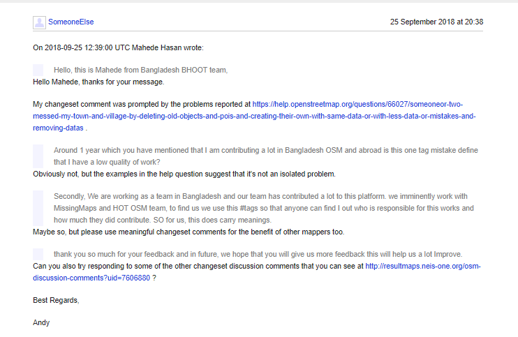
3 Answers:
Whenever you see a problem like this I'd suggest commenting on the changeset that causes the problem. I've done that on the "made all the road a bridge" example https://www.openstreetmap.org/changeset/62158983 in both English and machine-translated to Bengali. I'd suggest you do the same with the other problems. That does two things: It tells the person who made the mistake that there is a problem, and it tells other mappers that there is a problem too. Other mappers can see changeset comments such as that here. I would imagine that there will be quite a lot of comments that you need to make, but please do try and keep comments polite and helpful (like your "As I have noticed you are deleting..." message was - it explained exactly what the problem was. If that doesn't work, and people are still making poor-quality edits after being asked not to do so, please contact the Data Working Group by email via data@osmfoundation.org. We can send messages that users have to read before continuing to edit, and if all else fails stop users from editing for a period of time. Best Regards, Andy (from the Data Working Group) answered 24 Sep '18, 08:56 SomeoneElse ♦ 2 I have additionally commented on the changesets that deleted the school and the lake. I have also recommended that the mapper use changeset comments readable by humans, instead of a jumble of hashtags that nobody can understand without additional research. (24 Sep '18, 09:25) Frederik Ramm ♦ 1 Thank you for the useful comment. It is true and logical to comment on changsets. But I'm fearing to start seeing ammount of changes. It needs a research what was changed. May be one changeset changed a lot but I found only one or two, cause I have to click almost all the changed objects and see the tags and compare with previous osm file [not the latest one but saved it just]. Reverting will also lose their edits, which will hurt them too. Also need to research here, which one to revert or not, what will be lost etc. Huge time. Reporting to Data working Group is good, so we both can discuss, show what happened in where. But that needs time too which sadly I don't have now. But if I don't do something early, they would keep editing. Thats why just posted it immediately I found it. Cause I may have to wait for the end of next month. I will comment on changesets what currently I've found. (25 Sep '18, 04:59) zabir 2 There are a few ways of visualising changes in an individual changeset - https://wiki.openstreetmap.org/wiki/OSM_History_Viewer#Changeset_visualisation is one, https://wiki.openstreetmap.org/wiki/Achavi#Changeset_Viewer is another. (25 Sep '18, 21:32) SomeoneElse ♦ |
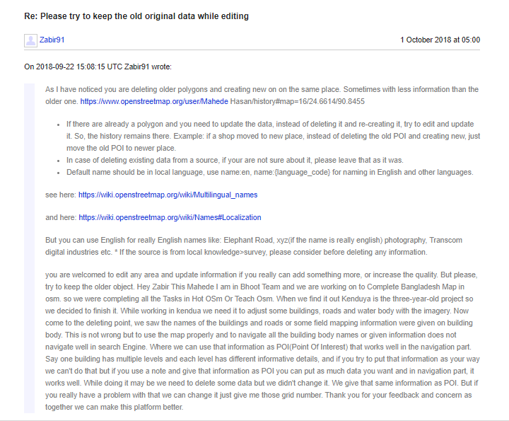
Dear Concerned, Hope all are doing well. From the opened thread here, I've come to know about the issue that something wrong is happening here due to the communication gap and misleading the real scenario to something else. Nobody is considering the background facts. Let me present the facts, and then you all can decide what actually happened. On July 6, 2018 the user 'Mahede Hasan' deleted several polygons drawn by the user 'zabir91', and added them as POIs. While doing this, as an oversight, the information related to the polygons had not been included. On September 22, 'zabir91' sent a message to 'Mahede Hasan's OpenStreetMap website inbox, complaining about the deletion of the polygons. On September 24, 'zabir91' posted here (this post). On September 24, the users 'woodpeck' and 'SomeoneElse' commented on changesets raising some concerns. On September 25, both of them was replied with appropriate explanations:
But one mistake we did had been replying to the inbox directly. And since replying to the changeset comments had not been possible because of a technical difficulty (we had tried to comment but they could not be added as replies), we admit that as our mistake. 'zabir91's message in 'Mahede Hasan's inbox had been missed by the user earlier (in the constant stream of validation messages, since he had been working on the complete grid, but that is not the point here). On October 1, 'Mahede Hasan' added the data that had been excluded by mistake (originally added by 'zabir91') to the newly-created POIs. Then he replied to 'zabir91', in the inbox, stating the reasons of the deletion and the re-addition of the POIs:
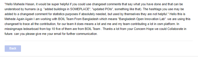
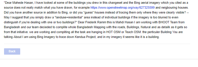
'zabir91' must have, hopefully, accepted our explanation and realized that we are only working to make the map a better one, since he made no more allegation. We are glad he recognized that we have the same goals, and that we are in no way competitors or enemies. We admit that it was our mistake to have deleted the polygons, and we are sincerely sorry that the situation developed so far as to hurt 'zabir91' in any way. On October 3, 2018 the user 'SomeoneElse' blocked 'Mahede Hasan's OpenStreetMap account, showing the reason for the block as not using "meaningful changeset comments". As seen in the screenshot attached above, it has already been explained to 'SomeoneElse' that we include the hashtags in the changeset comments (kindly note that we make appropriate comments first and then add the hashtags to the comments) so that they can be used to extract statistical data and detect which errors / inappropriate edits have been made by which contributor. This has been done in order that the responsible team leads can be contacted and the proper steps can be taken to prevent such mistakes in the future. All the contributions had been done tagged with '#BHOOT' or '#BOIL' had been done in order to track them. BHOOT (Bangladesh Humanitarian OpenStreetMap Operations Team) is the core team of coordinating the OpenStreetMap Bangladesh community, in support to OpenStreetMap Bangladesh Foundation. We have been working with close association with Humanitarian OpenStreetMap Team (HOT) and Missing Maps, supporting all the OpenStreetMap-based projects in Bangladesh initiated by any organization (government, NGOs, and commercial). We have built up a coordinated and methodical approach to community-driven contributions in OpenStreetMap. In the last year only, we have covered 20% of the whole country through 75+ tasks handled solely by BHOOT in Tasking Manager (both Teach and HOTOSM). This initiative eventually piled OpenStreetMap data in Bangladesh region from 18MB to 175MB in last one year. Through the project 'Map Your City', we have been tracing down all the map features available using satellite imagery initially ourselves, advocating OpenStreetMap-based data collection integrated to the projects by different organizations in those areas at the same time. To ensure more sustainability in this approach, we have organized numerous training and mapathons where 400+ new mapers have been trained for the OpenStreetMap platform. To have a good hold in coordinating and monitoring this massive amount of activities we have used these hashtags so that we can keep track of our operations all over the country. That is why, the hashtags '#BHOOT', '#BOIL' and '#Pathao' are meaningful hashtags to us. If you still think this is not meaningful enough and this is the cause of blocking Mahede Hasan, you might need to end up in blocking 120+ users from Bangladesh(If you need the user and task list, we will be happy to provide it to you as our goodwill to help you out!). Aside from our contributions inside the country Bangladesh, as a team, we have contributed more than 15% of the all-time contribution by Missing Maps contributors in OpenStreetMap, globally. Now, if someone says that we are doing these for credit, would you not say it is a complete injustice to us? Personally, I've been contributing, leading, helping and coordinating as a part of OpenStreetMap Bangladesh Community since 2013. During this period, I have been involved with almost all the osm-based projects throughout the country, including the specific task which has been brought out in the discussion which was actually initiated by Stanford School of Medicine. I've done field mapping over there physically. As we have seen lots of projects at that time were left unfinished, we have decided to finish tracing those up rather than creating a new task for that. It seems Zabir just emotionally drafted and filled an allegation straight away without waiting for a proper justification coming out from Mahede Hasan who has apologized and eventually recreated the deleted data and probably even more. In terms of localization issue, that Zabir has mentioned about, we have seen the organizations not using osm data lack of uniformity in naming(also distorts the name in the visual layer that makes OpenStreetMap unusable for common users). Moreover, in terms of using imagery, we are using MapBox and Digital Globe for satellite imagery to trace all the features as they are providing recent imageries. Another issue has been found that Zabir is commenting on a changeset that is in the Korail slum of Dhaka where National Institute of Health Research (NIHR) is conducting field level health projects, where the added data is going to be ground-truthed. If any data over there gets tempered, then it will hamper the project's outcomes in a way.
I hope, I've been able to mitigate all the issues and misleads regarding the whole incident. Please do communicate with me if any sort of other queries arises whenever you find '#BHOOT', '#BOIL' and '#Pathao' as hashtags in future. Bless you all! answered 13 Oct '18, 15:35 Sajjadsapan edited 13 Oct '18, 16:26 1 By all means use hashtags - but please use meaningful changeset comments as well. The reason for the block (and the repeat block) wasn't just a lack of changeset comments (see the block messages for details). It was a lack of willingness to engage with any of the issues raised in thos question, or in changeset discussions. (13 Oct '18, 15:44) SomeoneElse ♦ |


Dear SomeoneElse, Thanks for your response. In response to the first line of your comment, as it has already been mentioned in my earlier response, "we include the hashtags in the changeset comments (kindly note that we make appropriate comments first and then add the hashtags to the comments) so that they can be used to extract statistical data and detect which errors / inappropriate edits have been made by which contributor. This has been done in order that the responsible team leads can be contacted and the proper steps can be taken to prevent such mistakes in the future." The projects we do contribute on, are coordinated from an organizational approach. That's why those hashtags are used to keep track from our side. Secondly, as has also been mentioned in my earlier response, a direct response could not be given "since replying to the changeset comments had not been possible because of a technical difficulty (we had tried to comment but they could not be added as replies)". answered 13 Oct '18, 16:24 Sajjadsapan edited 14 Oct '18, 08:18 3 @all the help site is not a general purpose forum and in not suitable for drawn out discussions (in particular ones which have long left the realm of answering the question). Please move this discussion to a more suitable place, for example a mailing list or a forum. Thank you (13 Oct '18, 21:52) SimonPoole ♦ 3 There is a suitable forum here https://forum.openstreetmap.org/viewforum.php?id=97 (13 Oct '18, 21:53) SimonPoole ♦ |
Hi, have a look here :- https://wiki.openstreetmap.org/wiki/Data_working_group
They might be able to help and would be the best to give advice as to how to proceed. Good Luck!