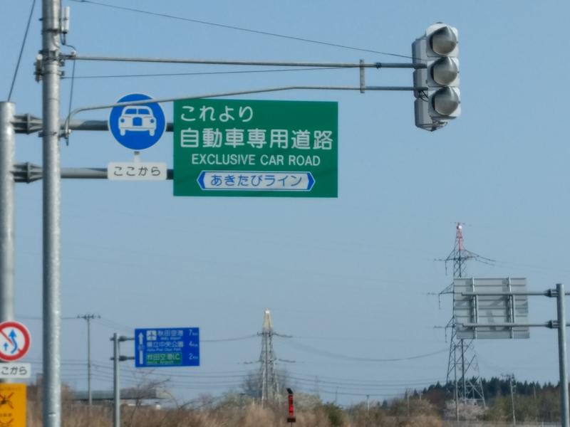
I have a little dispute with another mapper about two roads and I'd like to have some more opinions on the matter. First matter is Akita's underground highway: https://www.openstreetmap.org/way/574697538#map=18/39.71814/140.12357&layers=D This is without dispute a motor vehicle only road. In my opinion, and what I get from the English wiki, this road should be tagged as a highway=primary (like the connecting road) plus motorroad=yes (for the traffic restriction). The other mapper claims this to be a highway=motorway . In my opinion, highway=motorway are reserved for the country's largest inter city roads, which should apply to Japan too. Certainly not for an underground, motor vehicle only, traffic relaxation road of a city. The missing ref-tag supports my claim I think. The other mapper claims his decision is based on this wiki entry, https://wiki.openstreetmap.org/wiki/Japan_tagging , and I don't blame him for his decision judging only based on this article. But the article is imprecise and thus wrong (in my opinion) and I would update it accordingly should my opinion be the one that finds consensus. The other dispute is of the same kind, but for another road, which is even trickier, but I come to the same conclusion. It's this road (called あきたびライン): https://www.openstreetmap.org/way/177600397#map=16/39.6515/140.1774&layers=D The attached picture is the start of this road. My decision comes from the fact that this is primary a connector road to the airport. It has no highway ref-tag either. I would be ok with upclassifing this from primary to trunk. Please let me know your opinion on this, so that I can convince the other mapper (or you can convince me…).
asked 20 May '18, 12:37 bkn_jap edited 20 May '18, 13:52 |
One Answer:
if the goal is to find the new records in the official map, you need to use your option. However, the tag motorroad=yes is useless without a modification of the cartocss db queries. The road will not expose this particuliar qualifier with the current css. Then if the carto css xml must be modified, it depends the way this case will be handled. The final answer must come from the carto css team. No winner :) answered 23 May '18, 19:41 AntaC 4 We don't tag for the renderer. How motorroad=yes will be handled by CartoCSS or the current stylesheet is not relevant for this question. (23 May '18, 19:53) scai ♦ who are you to say "we" ? It is not in the question. Mapping not for renderring with a map or a data table is somehow something stupid ... (24 May '18, 03:05) AntaC 1 Unfortunately I think the Japanese community does tag for the renderer. I guess it's one of the reasons the mapper didn't like motorroad=yes, because it's not shown on Mapnik-Standard. Osmand correctly shows motorroads. (24 May '18, 03:25) bkn_jap Interesting... where is osmand ? does it publish its xml carto css file ? (24 May '18, 03:41) AntaC @scai, moderator or not, your comment was inappropriate (24 May '18, 03:42) AntaC and the 2 votes you got and the downvote on my answer show that this forum is flawed. shame on you (24 May '18, 03:44) AntaC 4 @AntaC: carto-css is only 1 of many uses of OSM data. There might be other apps (navigation apps, maps, GIS-applications) out there that use the motorroad=yes tag. Focussing on 1 map style is wrong. (24 May '18, 04:07) escada 1 @AntaC OsmAnd doesn't use CartoCSS. There are dozens of different renderers with different rules for OSM. Even more, there are vast numbers of other software and libraries using OSM, for example routing engines and geocoders. Tagging just for one single software and not caring for the rest is plainly wrong. (24 May '18, 08:05) scai ♦ moderator bullshit (24 May '18, 11:30) AntaC 1 @AntaC: I'm not a moderator. And what is "bullshit" ? Everything scai or I wrote is correct. (25 May '18, 06:25) escada 3 +1 "Don't tag something wrong just to make it show a certain way in one map rendering" has been a fundamental principle of OSM for a long time (25 May '18, 16:43) alester showing 5 of 11 show 6 more comments |
I guess the Japanese community is not very active at help.openstreetmap.org. Maybe you should try other contact channels such as the talk-ja mailing list or the users: Japan forum (very low traffic).
Thanks for the suggestion. Probably got to translate this in Japanese too…