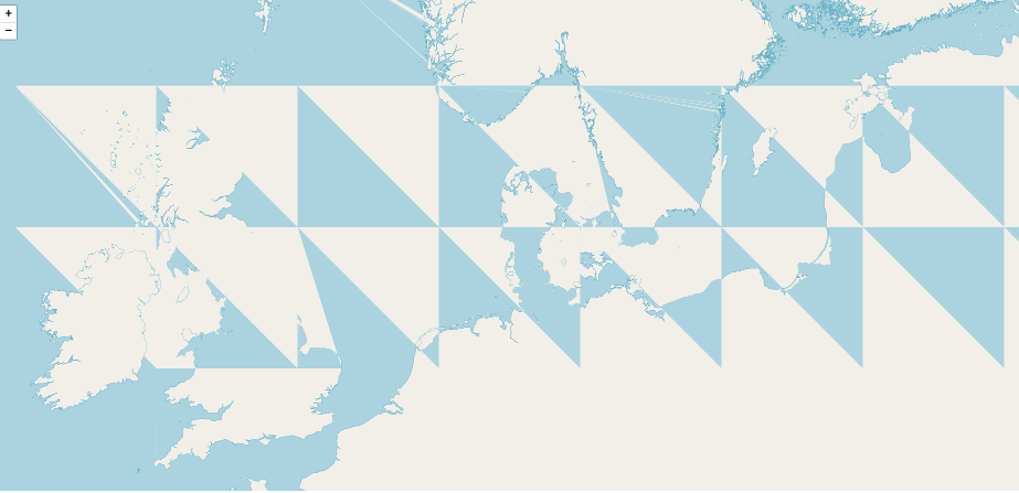
Please be as kind as to have a look at the attached image and say what is your first thought of the probable reasons for such malfunction. The setup is Tilestache/Mapnik/Nginx. PostgreSQL database contains OSM data and works just fine with the "standard" setup of Apache/mod_tile/Mapnik.
asked 22 Apr '18, 18:06 Mixroc edited 22 Apr '18, 18:07 |
2 Answers:
The short answer is that I don't know - the land / sea boundaries aren't "consistently wrong" across zoom levels (and as you say it works OK with Apache/mod_tile/Mapnik). Things to check might include:
... but as you can probably tell I'm mostly guessing here. answered 22 Apr '18, 21:07 SomeoneElse ♦ |
Hey! Thanks anyway. After wasting a whole day fiddling with various ways to install mapnik and the rest of the toolchain, fighting new non-compliances and errors where there were none before, I finally managed to get it working in a virtual machine with no problems at all, using - TADA! - exactly the same software I used before, but obviously different releases of it. The glithcy system was running bunsenlabs, the current successfull one is running ubuntu 16.04. The devil must have been in details, who knows where. Cheers! answered 24 Apr '18, 20:43 Mixroc |
What happens if you zoom in - do the triangles get bigger?
@SomeoneElse
Hi! Thanks for the reply.
If I zoom in, it, basically, remains in essence the same - a matrix of tiles of the same size with the background shifted in the same triangle manner, only at a larger scale.
If I zoom out, though, it becomes even more strange, as the map is almost normal, but there are defects in the background, with similar regular displaced light/dark triangles at the top of the screen, next to the Polar Circle, and, in addition to that, with long but narrow irregular diagonal triangles stretched out from three (in this particular case) locations in Europe with their top vertices converging somewhere above Iceland.
Another view at about mid-zoom: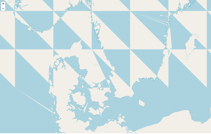
One of the views of the world: