Is there a way to remove the camera icon that appears in mapbox - which pulls data from openstreetmaps - for exhibits at zoos? the icon is distracting to users who think it is clickable. What data point controls this in openstreetmaps - and can it be edited? The camera icon should be use for scenic areas in parks, but not an animal exhibit. When openstreetmaps is used used inside other web-apps - the camera icon is distracting at zoos and creates a negative UX. asked 10 Mar '18, 21:18 CueContext |
2 Answers:
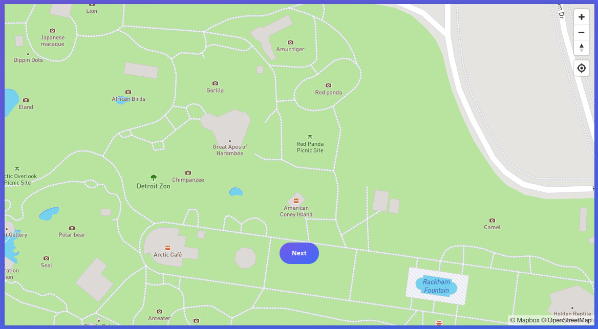
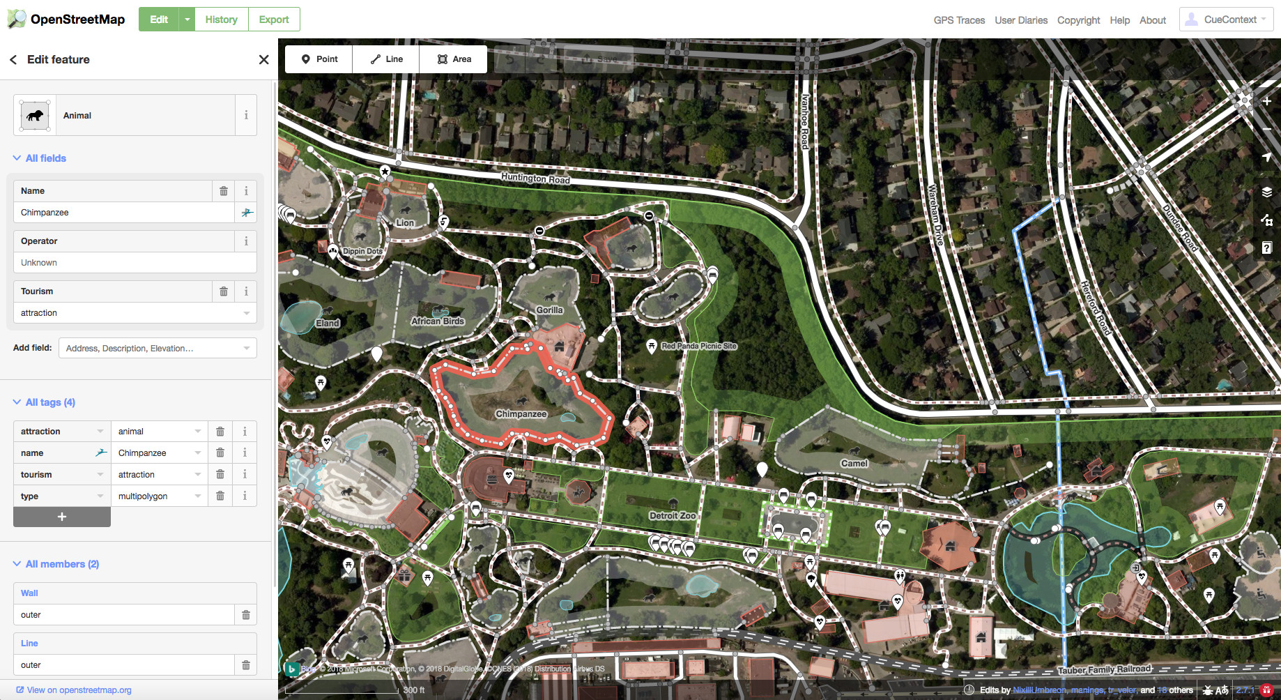
I have enclosed a screenshot from Mapbox (their "Nature" layer which can be seen here when you zoo in: https://www.mapbox.com/feedback/map/ ) and a screenshot from OpenStreetMap of the same area. Is there a cross reference between OpenStreetMap's meta data and Mapbox's Nature layer anywhere? I have tried making some changes in OpenStreetMap to the attributes of an exhibit area, but I did not see any change in the Mapbox map rendering. Maybe it is not a real-time sync or I did not edit the right fields. I have contacted MapBox, but I have not heard back yet. I will report what they say. In meantime, I would greatly appreciate any further guidance you can provide. If there is a simple reference anywhere that would do it.
answered 11 Mar '18, 17:36 CueContext 2 It looks like they're using an icon for things tagged "tourism=attraction". To take "Chimpanzee" as an example, it's in OSM as a relation https://www.openstreetmap.org/relation/2764536 . Your second screenshot shows the "iD" editor, and you've selected that object in your second screenshot. Mapbox have made a rendering decision to show a camera icon in the middle of this item in their map. If you'd like them to change that, you'll need to await their reply to your message. (11 Mar '18, 18:44) SomeoneElse ♦ Thanks for replying! I tried removing "tourism=attraction" but have not seen the change take effect in the Mapbox nature layer (it still shows the camera icon). When I hear back from Mapbox, I will post the answer back here. (11 Mar '18, 19:23) CueContext 4 Please don't remove the "tourism=attraction" if that's a valid description of what's there. Different maps make different decisions about how to show things - Mapbox's map is not the only one. If you remove the tagging it'll disappear from all maps. Another thing to mention - Mapbox's maps have been quite out of date for a while (for example, edits I made last year haven't appeared) so I wouldn't expect to see any changes on Mapbox's maps no matter what what you do (at least until they start updating again). (11 Mar '18, 19:33) SomeoneElse ♦ 2 I'll second what @SomeoneElse wrote. You should never change OSM data because you do not like the rendering on a particular map. Chances are that your action will be labeled as "vandalism". (12 Mar '18, 04:10) escada |
I understand and will respect that boundary. If I may, I would like to request further guidance, as this is not a personal view but rather a request from the Zoo executive team taking a pro-active role to improve (in their view) how their zoo is represented - based on how they wish to use OSM. To make this thread more complete, let me ask the question more generally in the following ways: Case 1: In the case of private property, can / should the land owners be able to manage the OSM attributes for their land? Case2: In the case of a non-profit that serves the public, can / should the land managers be able to manage their OSM attributes in ways that they feel best serve their mission and guest experience? Please assume the intentions are noble and not malicious. In both cases, how do you balance the goals / needs of the OSM commmunity with the goals / needs of the those who are responsible for the land management and use? Maybe the answer rests in how data layers should be modified up the stack, and not here? But still, who should really take ownership of the underlying OSM data? Thank you (to anyone who may reply) for helping to clarify this important topic. answered 12 Mar '18, 06:23 CueContext edited 12 Mar '18, 06:29 Perhaps it is better to create a new question for this. Can you create a new one and remove your answer and this comment ? And fix the typo OMS :) (12 Mar '18, 06:26) escada 2 Ok I've taken this an created a new question here https://help.openstreetmap.org/questions/62639/is-their-guidance-on-how-landattraction-owners-can-manage-mapping-of-their-properties (12 Mar '18, 11:25) SK53 ♦ ...and I've answered it there :) (12 Mar '18, 17:20) Richard ♦ |
Can you give an example of exactly which rendering you're talking about here? Mapbox (the company) produces a wide variety of maps for a wide variety of customers, so it's difficult to comment further without a bit more information. If it is a Mapbox rendering that you're talking about, then it's probably best to contact them.
I replied to in Answer area instead of the Comment area! Can you take a look at the additional info I provided and let me know if you have any other suggestions? Thank you!