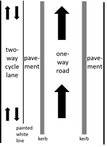
Hopefully this image is self-explanatory. A one way road with a pavement on both sides, the left pavement also has a two-way segregated cycle lane.
So how do I tag this and should I draw a separate way for the cycle lane? asked 26 Feb '18, 14:56 lakedistrict |
One Answer:
Since these are separated by a curb, I would draw a way for the one way road, and a separate way for the cycle lane which is tagged highway=cycleway. Unless I'm missing something, it looks like the Cycle Tracks Example T3. answered 26 Feb '18, 15:03 neuhausr showing 5 of 8 show 3 more comments |
Example T3 also suggests to add
oneway=noto the cycleway. Alternatively don't draw a separate way, instead addcycleway:left=track+oneway:bicycle=no(orcycleway:left:oneway=no?) to your highway.You'd need to draw it as a separate way. It is a seperate way on the ground.
Unless there's a more significant barrier than a mere kerb, this does not qualify as "physically separate", and should therefore not be mapped as a separate way.
@Tordanik, when I read kerb in the diagram, this was the sort of thing I envisioned, which seems like a physically separate way if I were driving or biking. If this isn't what you are meaning by kerb, could you clarify? Or if this is what you mean, could you explain why this doesn't qualify as physically separate?
@Tordanik @neuhausr For clarification, it's a stone kerb, like the ones at http://www.pavingexpert.com/edging5.htm#stone
Here is an example of a one way, bus only lane, with bus controlled rising bollards to stop general traffic. The two-way Foot and Cycle way are only separated by a white line from the Bus section. Cycleway is tagged as unset. https://www.openstreetmap.org/#map=19/52.33750/-0.14998
Not sure how this example could be mapped to route correctly without adding a separate way for foot and cycle traffic like this example.
When there's two different mapping/tagging approaches to a situation, I normally look around the local area to see which one is the most commonly used. However both methods (separate ways and single way) are used almost equally, but I think I'll just map it as one way for now.
Thanks for your help. :)