Hello MacBook Air 10.13.3 High Sierra I'm new to OSM, new to Basecamp and new to Garmin. My Unit came with Australia Maps installed on the SD card. I would like to install A new SD card with British Columbia maps. I downloaded the maps from OSM and have installed them on a fresh SD card. When I open them in Basecamp they don't show any Info except three Main roads. Does anyone have a solution? Please go steady with the tech speak, not my passion or for-te Many thanks in advance asked 14 Feb '18, 17:58 matthewalexhart edited 14 Feb '18, 20:41 aseerel4c26 ♦ showing 5 of 6 show 1 more comments |
4 Answers:
I am guessing the Garmin.img you are using was created some time ago. That map will only display the information that was in the OSM database at the time that the creator of that Garmin map downloaded the data. They may have put a date with the download For a more up to date map look search for OSM on Garmin and get a newer one. For the most uptodate you could follow these instructions. https://www.openstreetmap.org/user/SomeoneElse/diary/38613 answered 14 Feb '18, 19:20 andy mackey |
If you want a simple set of instructions I'd suggest these. They're quite old now, but the chances are they might help you understand what bit got missed out when you did it. answered 14 Feb '18, 19:34 SomeoneElse ♦ |
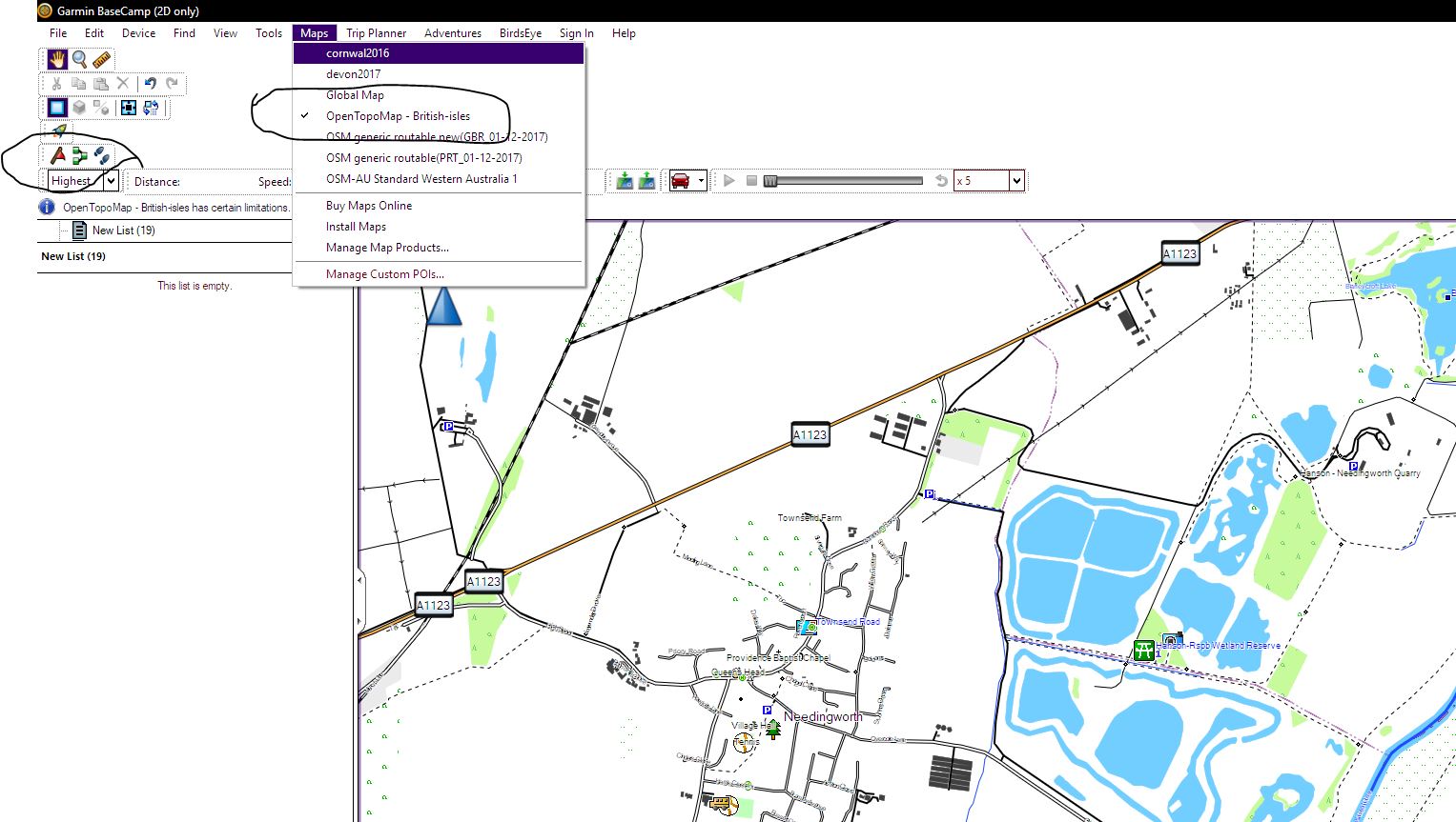
The problem may be getting the correct settings in Basecamp. Check you have selected the map or you will see a very basic one. The amount of detail shown can also be changed see circled items on Jpeg. answered 14 Feb '18, 20:28 andy mackey edited 14 Feb '18, 23:16 |
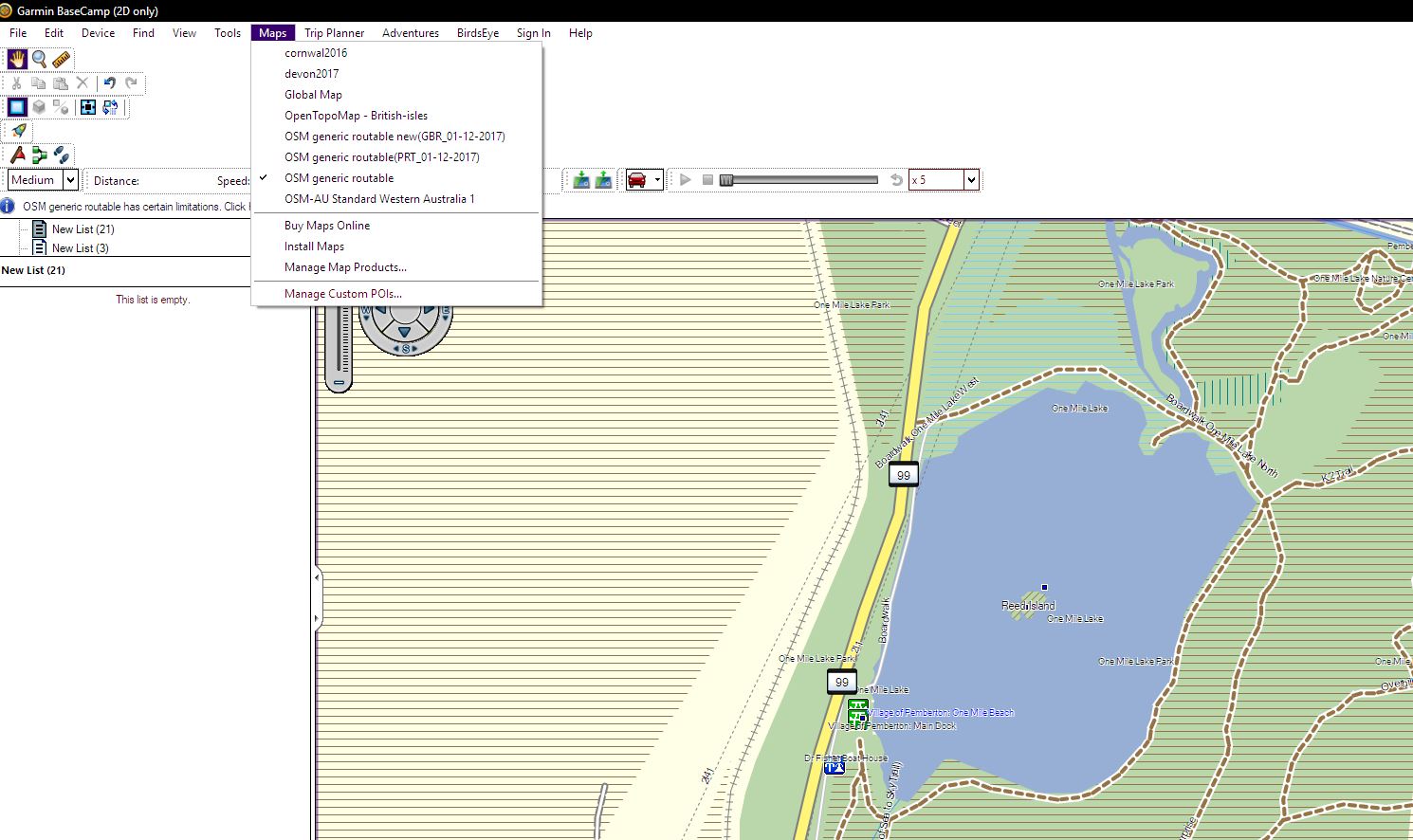
I don't have a MAC but using a WIN10 PC i downloaded a file from your link "osm_generic_gmapsupp.zip" I then placed that file in a folder called Garmin thats is in a plugged in SD (to PC) I didn't have to unzip it, (not sure if my PC did that automatically). I selected that file and choose open with Basecamp. It worked, I centred the Basecamp display over Reed Island BC https://www.openstreetmap.org/search?query=reed%20island%20BC#map=17/50.31075/-122.80390 so you can compare them. See Scr Shot of Basecamp. answered 15 Feb '18, 08:50 andy mackey Thank you, everyone who posted, it was detail sensetivity, once turned up, bingo the roads appered in base camp. Alas, when I exported the track to the GPS no detail showed up there? (15 Feb '18, 18:16) matthewalexhart My old Etrex Vista had detail setting in the unit under maps setting menu from memory. Maybe your newer model does as well. (15 Feb '18, 19:15) andy mackey 1 See the book http://static.garmin.com/pumac/eTrex_10-20-30_OM_EN.pdf page 32 map detail and map information to enable the map (15 Feb '18, 19:23) andy mackey 1 meta @matthewalexhart: do you mean that your setting of "detail sensetivity" (in basecamp?) was the problem? This is not mentioned in any answer here, right? You found it out yourself? Please post your findings as a new answer below, so others with the same problem can benefit. Thanks! (15 Feb '18, 19:58) aseerel4c26 ♦ This answer does "The problem may be getting the correct settings in Basecamp. Check you have selected the map or you will see a very basic one. The amount of detail shown can also be changed see circled items on Jpeg." (15 Feb '18, 20:40) andy mackey 1 meta @andy mackey: oh, thanks, did not see that in the other answer. @matthewalexhart: there is a checkmark icon beneath that other answer, click it to mark the answer as matching. (15 Feb '18, 21:02) aseerel4c26 ♦ 1 Hello Everyone Thank you for all your assistance. I created a Garmin folder on the SD card mounted in my Etrex 30. Then I added the gmapsupp.img to that folder. Now all data, roads etc show up when I turn on the eTrex. (15 Feb '18, 22:32) matthewalexhart matthewalexhart Questions and Answers can be voted up or down ( thumbs up down ) and best answer can be accepted (ticked) so that other users of the forum can more quickly scan for solutions. Thanks for your feedback it's good to know you got things working ok. Happy Mapping Andy (23 Feb '18, 22:07) andy mackey showing 5 of 8 show 3 more comments |
Where did you download the maps from?
In addition to "where did you download the maps from" it'd also be helpful to know what sort of Garmin unit you have. Different Garmins have different capacities; some can have more than one set of maps on at once and some can't. Also, when you say "and have installed them on a fresh SD card" what did you actually do? Can you explain the steps that you took to do that?
Does the British Columbia map display fully when the SD is in the GPS, is it selected in the maps menu on the device? If it displays the full map on the device but not on Basecamp the problem could be in Basecamp settings.
Some Garmin devices also have setting to show different levels of detail. These settings can speed up redrawing the display and make it less cluttered.
Hi all
Thanks for your responses, not sure whos see my return message?
osm_generic_gmapsupp.zip 41M Compressed file that contains a single image that can be placed directly onto the SD-card of the GPS.
Garmin Etrex 30 with a blank 16GB SD card mounted in the unit
The unit is showing no detail, neither is base camp.
Getting a "file contains nonmountable tiles" error
Thanks again
I tested that link with good results.. on a Win10 PC...see my latest answer.