Wow - you have to be totally dedicated to even get to this point! I can log on to openstreetmap with my google signin but I cannot use it to ask a question on the forum (here). Why? When I try to 'create an account' here using Yahoo - it keeps taking me the map page! Why? I don't even know if this is going to be posted. So I have submitted a trace. I cannot work out how this or when this will appear in the maps... Is there a resource which describes this and other ways to submit updates/changes? e.g. I have submitted a trace. Is that the same as editing? How long does a trace submission take to appear? If I check the maps online, and see no change, it's not worth downloading an update is it? I download from garmin.openstreetmap.nl. How long does a submitted trace take to appear in this download? Where is a step by7 step procedure provided for all this? Believe me - I'm not ignnorant of things PC and I am very persistent but this whole process is doing its best to dissuade me from getting involved. asked 29 Jan '18, 06:48 AlanMcD edited 31 Jan '18, 20:28 aseerel4c26 ♦ |
3 Answers:
When you searched for entry level OSM documentation, have you found the Beginners' Guide? If you have not found it, then let us know what search terms you used so that we can ensure it will be found by people in your situation. If you have found it, how can we improve it to be more helpful? Submitting a trace is not the same as editing the map; the trace does not contain the required additional information (what kind of road/path, name of road/path, does it connect to something else or lead over/under etc.). You need to fire up an OSM editor to actually draw a road/path on top of your uploaded trace in order to get something onto the map. answered 29 Jan '18, 06:53 Frederik Ramm ♦ 1 OK - so not all systems on the planet start with "Beginner's Guide". I searched for a common english question in google on how to submit changes to OSM. I didn't write down the question(s) I wrote and probably tried several times as logically as I could. I was taken to the submit trace pages. I authenticated using Google. I submitted a trace as prescribed. And now I see it's not the way to do it. I have recorded traces of roads/tracks I travel on (motorcycle). I assumed that that was the most accurate way of communicating the path. Editing on line has nowhere near that accuracy. And the trace docs mentioned something about averaging traces which seems reasonable. So now it's upload the trace.. THEN trace over it? I'll do some more work.... (29 Jan '18, 08:44) AlanMcD But when I found this forum. I was not provided a google auth method. It's amess really. Now I have a yahho AUTH for the forum and a Google AUTH for the maps (29 Jan '18, 08:45) AlanMcD Google AUTH accesses help,traces and editing seamlessly for me. (30 Jan '18, 07:33) andy mackey 1 @AlanMcD: Welcome! Just trash the third-party auths and just create an account on https://www.openstreetmap.org/ with username and password. Afterwards you can use this account to log in here and in the forum and of course use it to add changes to our geodata. (31 Jan '18, 20:29) aseerel4c26 ♦ 3 As a general note:for a long time the first entry on https://www.openstreetmap.org/help has been a link to the Beginners guide, really really really hard to miss if you are actually looking for help. (31 Jan '18, 21:23) SimonPoole ♦ Alanmcd, the questioner seems to to have found OSM via http://garmin.openstreetmap.nl/ and may have donated to them and then missed the beginners guide. He has not used his traces after five days, or posted here again. Because we have had zero feedback I have used his traces and ariel to map the tracks, I added a note and hope local mappers will correct any errors i have made. https://www.openstreetmap.org/user/alanmcd/traces (02 Feb '18, 08:57) andy mackey showing 5 of 6 show 1 more comments |
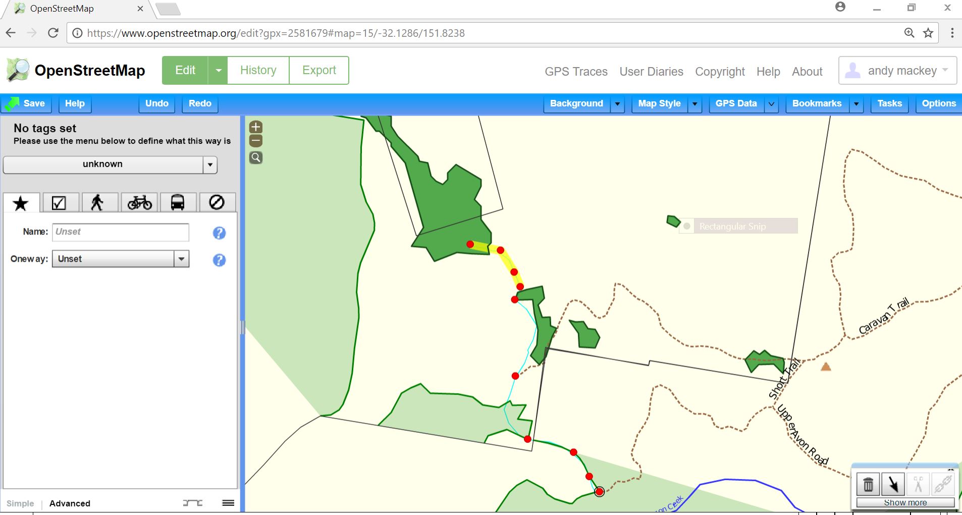
I found your Trace: From map page: click GPX Traces: Click See your Trace: Choose the Trace: Click edit: and this is what you will see. The thin Blue/Cyan line is the trace. I plotted some points ( By shift click) and i created the yellow highlighted way, next you would have to pick a road or path type, connect the end node(s) to the existing road then save it. I hope you get the idea. Happy Mapping. Note it will take a day or so for the way to fully appear on OSM ( after it as been saved,I didn't save the edit, it's your next job) The illustrated editor i used in this time was Potlatch2. Once the edit is saved it will be available as map data but you will then have to wait for the OSM on Garmin site you mention( or other one) to the use that data to build a Garmin map. It is possible to build your on map for a garmin and incorporate any trace you have, but very difficult. see Wiki. answered 29 Jan '18, 10:22 andy mackey edited 31 Jan '18, 21:14 1 Alan I didn't find your traces straight away, I had to use alanmcd (all lowercase) so maybe that why you have had to use Google and Yahoo. Both your traces seem to be of good quality. The traces are in areas that need more mapping which is good. Osm editing isn't too easy, but this forum and the OSM wiki as loads of information. Welcome to OSM Andy (29 Jan '18, 13:25) andy mackey I select Edit from My Traces, it appears as pink in the view screen, then when I select Edit in Potlatch2, the blue/cyan line does not appear (i.e. the pink line vanishes). I then need to drop down GPS Data, select the trace again and click Load. Now it's a cyan line. Now, no matter what I do, I can only start adding point. I cannot select the trace and edit it. I just get the fountain pen nib cursor and I'm stuck on the Add new points by dragging ... (23 Feb '18, 22:59) alanmcd OK - so I have to ALT-Click the trace to select it - but it only partially selects. I don't get the full length of the trace selected. So I'm now trying to work out how to either do it in stages and join them up after (23 Feb '18, 23:05) alanmcd Ok Potlatch2. First sign in with your lowercase name the same as your trace. hit shift/click should start a way ( path road or line) then move pointer and click along the cyan line. The ends of your track should usually join a road and probably end at a road with shift "j" to join the two ways. The box on the left is used to tag the "way" as path track road stream or whatever it is. (23 Feb '18, 23:23) andy mackey NOTE: Your traces were uploaded under one name and your first question under another, it's case sensitive Alan isn't the same as alan. So editing with one spelling with traces under the other may not display "your traces" (23 Feb '18, 23:29) andy mackey I need to split a trace into 2 parts and name one part one road and the other part another road. Can't seem to work it out. No options for splitting.. (23 Feb '18, 23:30) alanmcd This video may help https://vimeo.com/24984085 (23 Feb '18, 23:37) andy mackey To split a way at a node, you may need to make another node at the correct place, with the node highlighted use the scissor icon in the tool box to split it. Then tag the sections as required. (23 Feb '18, 23:47) andy mackey Are you saying I need to trace over the trace again? i.e. click on every track point? again? Is there not a way to select the cyan line, edit the details and save? (23 Feb '18, 23:50) alanmcd You can play and practice as much as you like. Use the undo button to take you back a step, or just exit WITHOUT saving if too confused. (23 Feb '18, 23:51) andy mackey Have a read of this, if you haven't already. It's nearly midnight here so I'll say goodnight. (23 Feb '18, 23:56) andy mackey @alanmcd: yes, you need to trace/draw over the trace again, in principle and as it is good practise in most situations (avoids strange zig-zag due to measurement errors of GPS). For rare situations you can convert a trace into a way in most advanced editors (JOSM and Potlatch2), I think not in iD. For Potlatch2, which you use in above comment, see https://wiki.openstreetmap.org/wiki/Potlatch_2/Shortcuts ("Ctrl+Shift-click (Linux) / Alt-click (Windows/Mac) – converts a vector layer object. Useful to convert a GPX trace to a way.") However, please take care when you use this. We are happy to review your result - please ask for this here. (24 Feb '18, 00:14) aseerel4c26 ♦ I actually have a habit of cleaning up my traces (tracks) in Basecamp. The interface for this task in Basecamp is very good and offers me the ability to keep a library of tracks to share. So I consider my traces already clean. I also verify them with aerial imagery. The only issue I later find is that the track may traverse more than one street name, so I need to split them and rename each piece, join as necessary to junction etc. (24 Feb '18, 00:51) alanmcd @alanmcd: okay, that is fine - just please take care not to use aerial imagery for for "clean"up which is not available in the OSM editor (simplified: only those are allowed). Note, that if you upload gps traces to osm (which are also available to other users), please upload the raw traces - not adjusted and error corrected with aerial imagery. For just using a trace for your own map editing you do not need to upload. (24 Feb '18, 01:00) aseerel4c26 ♦ sorry - this isn't very clear. I take bumps out of the track recording which are spurious bumps. The trace is a recording from my GPS. I see no reason to them click on every trackpoint again, especially when I can see from aerial imagery that there is no contradiction. (24 Feb '18, 01:12) alanmcd @alanmcd: Deleting obvious bumps is fine before uploading. Yes, as said, you do not need to click every trackpoint again. You can convert your trace to a OSM way and then do some connecting work to the other OSM ways. Be sure not to include a trackpoint every metre on a straight line - unneeded data density. (24 Feb '18, 01:19) aseerel4c26 ♦ the trace is question is 26km and has 975 datapoints (24 Feb '18, 03:42) alanmcd I edit traces ( with GPS Prune ) but i only delete birds nests and other fliers. I don't any add points as it would be to easy to create them from copyrighted sources which we MUST NOT do. (24 Feb '18, 15:40) andy mackey showing 5 of 18 show 13 more comments |
Maybe as you say " Wow - you have to be totally dedicated to even get to this point! " is correct. If it were too easy the map would not be so good. The dedication you speak of hopefully weeds out some contributors who don't care enough to make a good map. I guess you realised the GPX traces often have some junk attached so the need to tidied up a bit before uploading. Traces can't automatically be mapped as they could, in your case, be motorway, road, dirt track, off road or a trespass which is where you, the surveyor, come in. You have to remember the details. Luckily the Ariel backgrounds help us to remember the details, or take notes,or use a dictaphone. OSM is run by people like you and me who care enough to get it right, if it isn't right we can fix it. You can complain about the user interface but the whole project is free and made by volunteers doing the best they could at the time with the resources available. If you can improve it please do. Your traces look good and are in an area that as few other traces so please use them to map the tracks? or roads, i'm guessing, that you rode on to improve OSM a few steps more. Happy Mapping answered 30 Jan '18, 07:07 andy mackey edited 30 Jan '18, 16:02 |
This is what it says about on garminosn.nl site on GPX traces https://wiki.openstreetmap.org/wiki/Upload#What_happens_to_my_file_after_it_has_been_uploaded.3F you will have to check their site or contact them to ask how often they renew their download of OSM data to build a Garmin.img, which won't have your traces in it until they are mapped.