NOTICE: help.openstreetmap.org is no longer in use from 1st March 2024. Please use the OpenStreetMap Community Forum

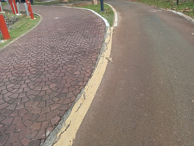
Refer to the photo below:

One track with two different surfaces

This is a highway in a park. Beyond the diverging point - to the left - is a path with surface=paving_stones reserved for foot (jogging, running, etc).

To the right (I presume, after walking around) is closer to a service road with surface=asphalt. Probably more suitable for cyclists, but I've seen a vehicle that looks like a golf cart (this is not even a golf course) is using this service road as well. And of course, motor vehicles aren't allowed here.

The combination of these two is currently mapped as a highway=path. So, any ideas how to represent this two things together?

asked 27 Jan '18, 05:27

AkuAnakTimur's gravatar image

AkuAnakTimur
1.1k91731
accept rate: 6%

edited 27 Jan '18, 11:03

aseerel4c26's gravatar image

aseerel4c26 ♦
32.6k18248554


Especially

  • if the access rules are different for both parts and
  • if the ways diverge also at other locations,

I would map them as two parallel ways (with own highway (path/service), access and surface/smoothness tags). At your photo they even diverge and have to be mapped separately anyway.

  • highway=path
  • foot=designated
  • surface=paving_stones
  • smoothness=intermediate

and

  • highway=service
  • private=yes (that is just guessed because of your "golf carts" - adjust for reality!)
  • bicycle=permissive
  • surface=asphalt
  • smoothness=good or even smoothness=excellent

Another option would be to treat the left path as "sidewalk" of a road (the one on the right). See https://wiki.openstreetmap.org/wiki/Sidewalks#Sidewalk_as_refinement_to_a_highway

Also note the comments below.

permanent link

answered 27 Jan '18, 11:01

aseerel4c26's gravatar image

aseerel4c26 ♦
32.6k18248554
accept rate: 18%

edited 27 Jan '18, 13:49

2

Separate ways should only be used where there's physical separation, which isn't the case here. The reality on the ground changes where the ways split/merge, and the mapping should reflect that.

I think using a sidewalk tag is the least bad option here.

(27 Jan '18, 12:43) Tordanik
1

@Tordanik: thanks for your comment, yes, I agree. I think it is a choice between compromises / bad options. From what it looks like, it also is not really a sidewalk - likely both ways are quite equal in importance.

(27 Jan '18, 13:42) aseerel4c26 ♦
Your answer
toggle preview

Follow this question

By Email:

Once you sign in you will be able to subscribe for any updates here

By RSS:

Answers

Answers and Comments

Markdown Basics

  • *italic* or _italic_
  • **bold** or __bold__
  • link:[text](http://url.com/ "title")
  • image?![alt text](/path/img.jpg "title")
  • numbered list: 1. Foo 2. Bar
  • to add a line break simply add two spaces to where you would like the new line to be.
  • basic HTML tags are also supported

Question tags:

×930
×193
×112
×30

question asked: 27 Jan '18, 05:27

question was seen: 2,094 times

last updated: 27 Jan '18, 13:49

NOTICE: help.openstreetmap.org is no longer in use from 1st March 2024. Please use the OpenStreetMap Community Forum