I have been browsing through the OSM-Inspector tool and it has come to my attention that many buildings in southern Europe still have internal courtyards (Atriums to the ancient Romans / Patios to the Spanish, I think, Innenhof to the Germans). Mappers are often using ways with overlapping sides to map this feature which creates a failure in OSM-Inspector. I would have thought that the best way to map these buildings would be to create a multipolygon for the building ie. outer and map the courtyard as landuse=courtyard or atrium or patio but I could not find anything in the map features or proposed features page. So I have come to the conclusion that I am missing something. What is it? asked 18 Jun '11, 19:13 dcp closed 19 Jun '11, 10:55 |
One Answer:
To add courtyards and other "holes" in buildings use a multipolygon relation. Add a relation with the tags type=multipolygon and building=yes, and a member #1 with role:outer and a member #2 with role:inner.
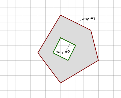
answered 18 Jun '11, 21:09 Gnonthgol ♦ Yes, I know that. But what tag/attribute do I give the inner? With the above diagram, I know that I must generate a multipolygon with two elements; one as outer the second smaller one as inner. The outer defines the multipolygon as building=yes. The inner requires a valid tag like landuse=garden but the point is: It is not a garden it is a ??????. Is ?????? a courtyard or an atrium? Atrium is probably wrong as it defines a covered space within a modern building complex. See http://en.wikipedia.org/wiki/Atrium_(architecture) (19 Jun '11, 09:09) dcp 3 The ways does not have to have any tags at all. All building= and addr tags go on the relation. If you are unsure of the inner polygon leave that way without any tags. See the pentagon https://www.openstreetmap.org/browse/relation/89605 for reference. An atrium with a covered glass ceiling should be considered as part of the surounding building as it is part of the roof structure. (19 Jun '11, 09:39) Gnonthgol ♦ Thank you for the prompt answer. I was unaware that objects can have no tags. I suppose the renderers can cope with them somehow and the validators should be ignored. (19 Jun '11, 10:55) dcp 3 @dcp: Actually, it's true that usually objects without tags are useless, because they do not mean anything. The exception are objects which are part of a relation. These can be without tags, because the tags are on the relation (though the relation members can have tags of their own if appropriate). (22 Mar '12, 20:00) sleske |
You should not close a question because it is answered but rather mark the answer as accepted.
I cannot see how to mark an answer as "accepted" other than the way I did it!
@dcp: I took the liberty of re-opening the question. Closing a question is not appropriate if it was answered. To mark an answer as accepted (which is recommended if it answers your question), just click the "checkmark" icon under the up-/downvote buttons.