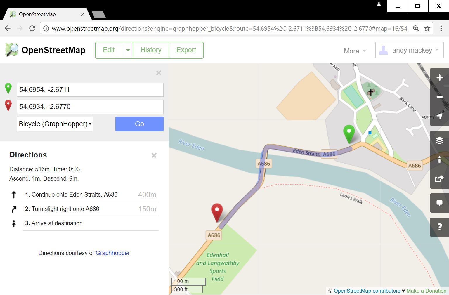
I recently posted this on GPSies: I live in Penrith UK and I've been trying to plan routes following the A686 going north east to Alston. The route will follow the road to the bridge over the River Eden at Langwathby but refuses to cross the river. Anything plotted on the north bank causes it to backtrack and find a bridge somewhere else, usually at Lazonby. There is definitely a bridge at Langwathby, even if it is still the temporary one they put in to replace the original bridge which was washed away some 50 years ago. Can anyone explain what is going on? It got the following reply: I think the bridge is not correct with the path/way/road connected. If you want, you can fix this in the editor at the open street map homepage. Or you ask at the osm community if someone do this for you This is beyond my current IT skills. Can anyone offer guidance or fix the problem please? asked 31 Jul '17, 09:58 Roger Butter... |
4 Answers:
Are you doing bicycle routes? The bridge looks to be OK for car and foot routing, but is set to exclude bicycles. If bicycles aren't allowed on the bridge, then they can perhaps be pushed over the footbridge in which case it should probably be bicycle=dismount rather than bicycle=no answered 31 Jul '17, 11:09 EdLoach ♦ edited 31 Jul '17, 11:13 3 Interestingly the other part of the pedestrian bridge is tagged with bicycle=yes. This is contradicting. (31 Jul '17, 12:07) scai ♦ 1 And both bits are part of the NCN 7 route relation, which suggests no is unlikely. (31 Jul '17, 13:28) EdLoach ♦ 1 I was planning a cycle route when I encountered this problem. Since I posted I had played about with GPSies and found that I could get over the river as a car or pedestrian and then switch to being a cyclist. So if the bridge is set to exclude cyclists this would make sense. However it is curious that this is the setting. The bridge is single lane controlled by traffic lights and there is a separate pedestrian footbridge alongside. There is a sign saying "cyclists dismount" and I'm never sure if this is mandatory or advisory. Even if it's mandatory it's possible and legal to push the cycle over the footway, and this is certainly preferable to a 10 mile detour. The Sustrans C2C crosses the bridge so any route planning system which excludes cycles is not very helpful. (31 Jul '17, 21:05) Roger Butter... 1 Roger its common practice to change pedestrian into cycle despite of traffic signs just to avoid D tour due to cyclist=no instead of cyclist=dismount (01 Aug '17, 00:26) Hendrikklaas 2 @Roger - it sounds like they're routing cyclists over the footbridge, but want you to dismount. I'd expect that most bicycle routers should understand "bicycle=dismount" https://taginfo.openstreetmap.org/tags/bicycle=dismount as it's widely used. @Hendrikklaas for the avoidance of doubt the tag is "bicycle=dismount" not "cyclist=dismount". (01 Aug '17, 07:39) SomeoneElse ♦ Another bit of information. The "cyclists dismount" only applies when crossing the bridge from S to N. Coming the other way there are no restrictions and cyclists can use the vehicle bridge. Nevertheless trying to plan a route over the bridge as a cyclist results in the long detour via Lazonby. (01 Aug '17, 10:23) Roger Butter... showing 5 of 6 show 1 more comments |
Note that different route-planners may produce different results. For example, CycleStreets (like GPSies) appears not to route over the bridge in this case, but cycle.travel will do so willingly: http://cycle.travel/map?from=Langwathby&to=54.6933,-2.682 answered 01 Aug '17, 14:20 Richard ♦ I just tested it with the two map page bike routers, GraphHopper and Mapzen in both directions and they both fail, but the tagging looks ok to me. It is possible that it may be tagged correctly, but we know edits to routing can take days to be used by routers. (01 Aug '17, 15:24) andy mackey 1 https://www.openstreetmap.org/way/326550904 is the issue - it's set to bicycle=no. cycle.travel assumes that the NCN 7 route relation overrides this, which the others don't appear to do. (02 Aug '17, 09:33) Richard ♦ Thanks Richard i missed that, i only looked at narrow foot bridge not the ramp. I edited it to bicycles allowed so it should route ok in a while. (02 Aug '17, 13:25) andy mackey Personally, I would have routed the NCN over the road bridge as the blue signs are advisory & only in one direction. Many riders find leaving & especially rejoining traffic flows to be more dangerous than staying in the road. If the NCN is to remain on the footpath then https://www.openstreetmap.org/way/124356979 needs trimming I've never understood the logic of 'cyclists dismount' for narrow ways as someone pushing takes up twice the space. (06 Aug '17, 16:47) DaveF |
answered 04 Aug '17, 10:16 andy mackey edited 04 Aug '17, 10:25 |
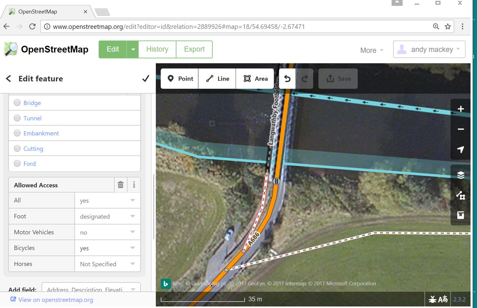
 coast to coast route. So how did i edit it? 1 click edit 2 select id 3 click on the way, inspect it 4 change it to cycle =yes 5 save edit
answered 04 Aug '17, 10:27 andy mackey edited 04 Aug '17, 10:28 Sorry i tried to illustrate the routing and the editing, but the system would not accept both jpegs. I hope the editing instructions with the routing pic make sense with the second jpeg. (04 Aug '17, 10:33) andy mackey More on iD editor:- https://wiki.openstreetmap.org/wiki/ID (04 Aug '17, 10:37) andy mackey |
Hi Roger, what kind of vehicle do you want to use ? Both bridges have restrictions in traffic, changing from bicycle to pedestrian on the road next to it. You need a local view to determine whats happening.
This one https://www.openstreetmap.org/relation/2889926#map=17/54.69490/-2.67471