Hi, Bing has recently updated their imagery in a lot of places in Dhaka, Bangladesh and possibly world wide. While the new imagery is more recent, the old imagery had some advantages as the buildings were distinguishable in it because there were very less slanting of buildings. The new imagery however is harder to work with in dense areas because a lot of buildings get covered behind tall buildings. It was easier to draw with the old imagery and then compare with a newer one and then adding the new buildings. So, I was wondering, is there anyway I can use the previous Bing imagery? Any links? Thanks asked 09 Apr '17, 05:41 mmahmud edited 09 Apr '17, 05:42 |
One Answer:
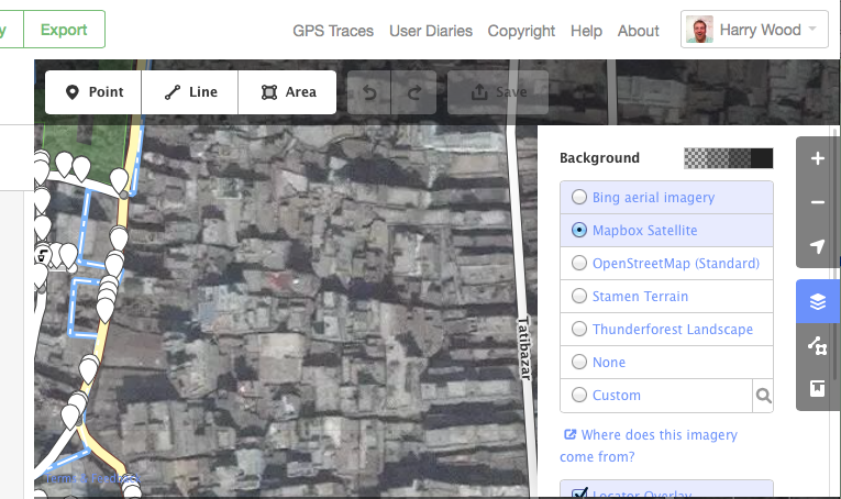
Not from bing itself. They just provide one imagery layer. It's a mishmash of different ages of imagery (generally digitalglobe imagery I believe), but in any given location I'm afraid they're serving... just one age... one quality imagery ...one layer However bing is not the only imagery provider. You can swap to others within the OpenStreetMap editors quiet easily to see if you get anything different. Some imagery providers are (sort of) global coverage. Mapbox for example will be available where you are if bing is. Mapbox is often identical to bing, but sometimes a different age of digitalglobe imagery... ...which seems to be the case in Dhaka. Judging by shiny new buildings visible in bing I'd guess Mapbox has slightly older imagery there. It may actually be the exact images you were originally working with via bing:
answered 11 Apr '17, 11:52 Harry Wood |
Thank you for the suggestion. However, MapBox imagery and current Bing imagery are kind of the same with the slanted buildings. Was looking for the complete over the top view that Bing had previously. I have to cover a large number of dense areas and previously I did so by using the Bing imagery to draw out all the buildings and then comparing it with a newer imagery by Digital Globe and ESRI to add the new additions.