This Diary Post and a comment prompted this question:
Ideas? asked 19 Feb '17, 08:30 andy mackey edited 19 Feb '17, 18:39 aseerel4c26 ♦ |
4 Answers:
If your question is "How To" then either stop to make notes where the speed limit changes (though you might class this as a distraction), or use a dashcam or something like Mapillary or OpenStreetCam and check for changes when you're stationary. answered 19 Feb '17, 09:46 EdLoach ♦ I don't know what the current status is, but Scout at least had a prototype of real time sign detection in their mobile app: http://sdkblog.skobbler.com/scoutsign-osm/ (19 Feb '17, 14:40) maxerickson |
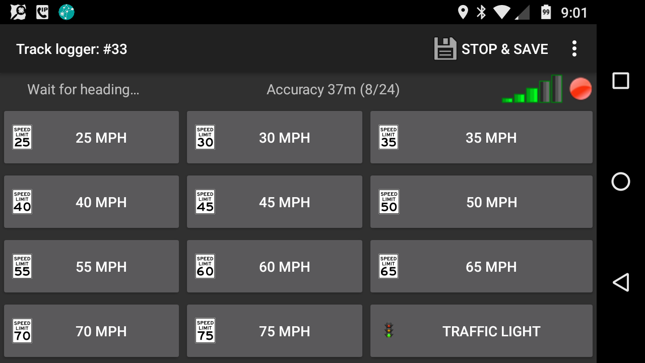
I created a custom set of buttons for OsmTracker that has a button for each of the normally encountered speed limits in my area all on a single (default) screen. I can just tap the appropriate button as I pass the speed limit sign.
If desired, I could post the file and its associated button images but they are for US style MPH signs. No reason the concept couldn't be applied to other countries though. answered 19 Feb '17, 17:05 n76 If I understand correctly, while your driving you have OSM open and you just tap the speed limit button as you pass it and it automatically makes changes? That would be amazing!! (23 Aug '23, 19:38) 352Guy Not quite that easy. It created a OSM file that had a point with the speed limit information. I still had to use an editor to place the max_speed=* on the road itself. And if it was a location where the speed limit changed I had to split the way. That app worked on Android. I have since migrated to iPhone and been unable to find an equivalent app. So my current work flow is to use my dashcam. I have documented that at https://retiredtechie.fitchfamily.org/2018/05/13/dashcam-openstreetmap-mapping/ (23 Aug '23, 19:55) n76 1 I used the voice note feature with the cheap earpiece n mic that comes with phone purchase, the ideal setting for me is 3 seconds. For pois/street names, I even spell them out sometimes! (25 Aug '23, 15:19) kucai |
Hi Andy / Ed, What about the good old Dictaphone with a tape or digital, both hands on your wheel, but the pain comes later, listening to rumble or nothing between traffic signs, although quality of a surface is easy to mark in the meantime. Mark/describe the place/situation well. answered 19 Feb '17, 14:35 Hendrikklaas edited 19 Feb '17, 15:47 |
Be a passenger, not a driver. answered 23 Aug '23, 20:03 SomeoneElse ♦ Does that include using self-driving cars? ;) (24 Aug '23, 00:35) scai ♦ |
I have found a few apps (android in my case) that will control the phone camera and take an image at a voice command. I will report back if i find one that works for me.