NOTICE: help.openstreetmap.org is no longer in use from 1st March 2024. Please use the OpenStreetMap Community Forum

This question is very similar to this question, but asking about a different kind of flow / water level control mechanism.

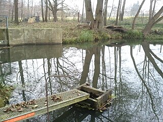
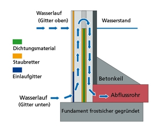
Pond water level mechanism photo Pond water level control mechanism schematic
(credits: image 1: Patrice77 CC BY-SA 3.0; image 2: Gerd Baumann)

Managed ponds (especially those to used for fish farming) often have a water level control mechanism similar to a sluice gate that consists of a drain pipe with an adjustable height in a small case. I don't know what it is called in English, but in German and some other languages it is called "monk" (see e.g. German Wikipedia). What is the best way to tag these?

asked 06 Aug '16, 08:46

moonrusha's gravatar image

moonrusha
31112
accept rate: 0%

edited 06 Aug '16, 09:13

aseerel4c26's gravatar image

aseerel4c26 ♦
32.6k18248554

The category of those images at Wikimedia Commons also has no English Name. Maybe none exists?

(06 Aug '16, 08:59) aseerel4c26 ♦

Unless you find something better, I would go for this:

  • waterway=flow_control
  • flow_control=moench

But what about the tags flow_control=overflow or flow_control=water_level from http://taginfo.openstreetmap.org/keys/flow_control#values ?

In such rare tagging cases I like to add a description (possibly just your Wikipedia link) tag, too.

permanent link

answered 06 Aug '16, 09:25

aseerel4c26's gravatar image

aseerel4c26 ♦
32.6k18248554
accept rate: 18%

Follow this question

By Email:

Once you sign in you will be able to subscribe for any updates here

By RSS:

Answers

Answers and Comments

Markdown Basics

  • *italic* or _italic_
  • **bold** or __bold__
  • link:[text](http://url.com/ "title")
  • image?![alt text](/path/img.jpg "title")
  • numbered list: 1. Foo 2. Bar
  • to add a line break simply add two spaces to where you would like the new line to be.
  • basic HTML tags are also supported

Question tags:

×930
×79

question asked: 06 Aug '16, 08:46

question was seen: 4,143 times

last updated: 06 Aug '16, 09:25

NOTICE: help.openstreetmap.org is no longer in use from 1st March 2024. Please use the OpenStreetMap Community Forum