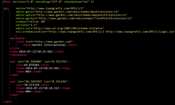
I have troubles when uploading waypoints .gpx file to OSM coming from a Garmin eTrex20 GPS receiver. I have no problems at all for .gpx files containing traces... The message I get after upload failed is: « Found no good GPX points in the input data ». Here is an extract of the file (sorry I can't enter code directly because HTML tags are not ignored in the post, although with 4 spaces before...):
Any idea on this issue? asked 21 Jul '16, 12:44 wiltomap edited 22 Jul '16, 06:38 aseerel4c26 ♦ |
One Answer:
This previous answer describes the problem - your GPX file has only waypoints in it, but no GPS track. Add a couple of track points (as per this test example), and you will be able to upload it, and you'll then be able to process the waypoints. However, in this case there doesn't seem to be much information in the waypoints - is there any reason why you're uploading those rather than a GPS trace? answered 21 Jul '16, 12:51 SomeoneElse ♦ showing 5 of 11 show 6 more comments |
Thanks @SomeoneElse! I'm gonna try this. I do need this waypoints file for it contains thousands of plotted trees, benches, street lights, etc. What I'll do next time is to put my waypoints inside a trace file before uploading!
Why do you want to upload GPX waypoints to OSM? There is no value in doing this. Also these waypoints won't magically appear in OSM, that's not how OSM works. You have to add them manually to the map using an OSM editor. See the beginners' guide for more information.
@scai - uploading waypoints to OSM in traces is exactly how I map all the time , as per https://github.com/SomeoneElseOSM/osmimport_02 !
@scai I'm not a beginner and used to JOSM. I need waypoints to position point elements such as street lights, trees, etc. I perfectly know that I will have to create manually as many points with an editor. I perfectly know that there is nothing 'magic', as you say.
By the way, how can I add HTML code inside a post without having HTML tags interpreted for post layout? The four spaces before a tag change nothing...
(re HTML) from memory it might be that HTML is hidden in preview mode but not afterwards, even if you've said via Markdown that it should be code. There an answer to another question here somewhere along those lines, but the search here is a bit rubbish so I can't immediately find it.
Oh, I didn't know that uploading GPX waypoints can be actually useful. In that case the upload API restriction should get removed.
Maybe I'm missing something, but why not just open the GPX file directly in JOSM as an additional layer? I do this all the time and assumed this was the way it should be done. :)
@alester It depends on what you'd like to see in the waypoint, but the problem I had when I last tried it was https://help.openstreetmap.org/questions/6368/in-josm-is-it-possible-to-see-gpx-track-waypoint-details .
@SomeoneElse Gotcha, I always put the relevant information in the name so it hasn't been a problem for me, but I can see how it could be a problem if you use the description.
@wiltomap: regarding html: I have made the experience that the preview here is not really a preview. The final rendering is different. The preview of https://daringfireball.net/projects/markdown/dingus is better to preview. In fact, it works to indent with 4 spaces.