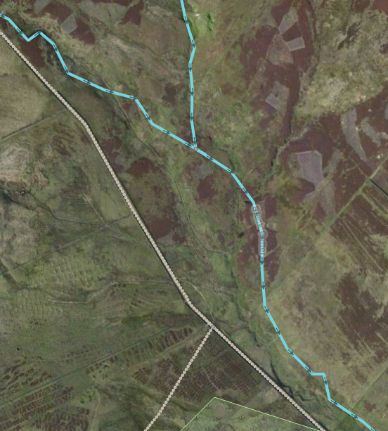
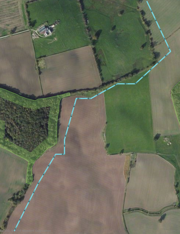
(Click either image to go to the location in iD) Image 1:
Image 2:
asked 11 Jul '16, 00:24 BarnsleyOli edited 11 Jul '16, 19:39 aseerel4c26 ♦ |
3 Answers:
Because they were done before half-decent imagery (or OS OpenData) became available! Most of the "inaccurate" ones were done from old out of copyright "New Popular Edition" maps, and there can be significant errors in those (i.e. 10s of meters offset, due to actual map errors not just rectification). Also, early releases of OS OpenData tiles often had significant offsets (now mostly resolved) and Bing imagery, particularly in hilly areas had significant offsets too. There are also now more (and more accurate) GPS traces that allow other sources to be sanity checked. OSM has always proceeded on the basis of incremental improvement, as sources get better, the map gets better. Based on a mixture of survey, OS OpenData and Bing I've been gradually tidying up some of the streams in Mid and South Wales, and other people are doing likewise there and elsewhere. It's mostly a winter evening job though - too much "post survey mapping" to do in summer. answered 11 Jul '16, 00:34 SomeoneElse ♦ |
Just a thought re Image 2 ..... was originally mapped about 7years ago by SK53 with source shown as 'NPE'. I don't know what NPE stands for but I wonder if there was perhaps a small stream/ditch following the (more or less) adjacent treeline/hedgerow? Some tidying up using up-to-date imagery as suggested by SomeoneElse would be good. On the ground survey would be even better. answered 11 Jul '16, 01:18 NZGraham 1 NPE is out-of-copyright New Popular Edition maps, as SomeoneElse posted above. (11 Jul '16, 12:38) Richard ♦ I was used a lot before bing was available and is still one of the available editing back grounds, we can still use now. NPE is 50+ year old Ordnance Survey Great Britain. I think user blackadder collected and scanned them. They are in my opinion a great map series. https://www.openstreetmap.org/user/blackadder (11 Jul '16, 17:46) andy mackey I've just tried to check if my memory is correct, without success, perhaps Richard can confirm my senility or not, Please. (11 Jul '16, 18:14) andy mackey 1 :) Actually I scanned them! But the original scans were rectified very very roughly for the use of npemap.org.uk, a postcode-collecting site. Someone took it on themselves to make them available as WMS for JOSM, which was not my intention. I later rectified them much more accurately, with a control point every 5km, and that's the layer that's available now. I think most of the approximate streams date from the original rough rectification. But it was a long time ago and I may have misremembered! (11 Jul '16, 22:54) Richard ♦ Sorry and Thanks Richard (11 Jul '16, 23:43) andy mackey |
There might be another twitch, rivers mapped with JOSM as accurate as possible tend to deform after the saving process, how or why ? The count of nodes ? It happened several times not at the same day so it should be reproducible. answered 11 Jul '16, 20:42 Hendrikklaas huh, could you please provide a link to one of your changesets where it happens? could you please describe how you mapped the river in JOSM? (11 Jul '16, 21:16) aseerel4c26 ♦ Hi Ill search for it and will be back with a link or more. Using JOSM and node by node on the correct spot. After saving the river it showed some or many shortcuts. Which were not made by me, I don’t work like that it’s just as good as it is using different type of aerials. (11 Jul '16, 22:17) Hendrikklaas During floods and during periods of rapid flow streams do erode the outer curve of banks, if not reinforced, sometimes leaving oxbow lakes. https://en.wikipedia.org/wiki/Oxbow_lake (12 Jul '16, 00:01) andy mackey |
maybe it is useful to mention how to see the age of a stream's positions: view the object history of some of its nodes.