How can i map the position of several new wind turbines that are on private land without close access. asked 22 Jun '16, 08:30 andy mackey edited 24 Jul '16, 08:58 aseerel4c26 ♦ |
One Answer:
I have solved this but thought my solution could be useful to others. I welcome suggestions and better answers. I thought about using compass bearings or even using cheap protractor with sight line of some sort. I then thought of a simpler idea. I noticed that any pair of turbines would be in line from some points ( obviously) and if i eye balled from the surrounding road i could mark a waypoint on this line but to fix this line i would need to create another waypoint from the other side of the site. I was aided by the fact that the turbines were in two almost straight lines of four turbines each. I created 12 waypoints then uploaded these in Potlatch2 in as background (under vector). I then created a blank way joining the dots (waypoints) and the new intersections are hopefully pretty close to the positions of the turbines. I put nodes at these points and tagged them. I have left the invisible lines ( on map page) as it is untagged way in the data for the time being. see pic:
answered 22 Jun '16, 08:56 andy mackey edited 24 Jul '16, 08:57 aseerel4c26 ♦ showing 5 of 8 show 3 more comments |
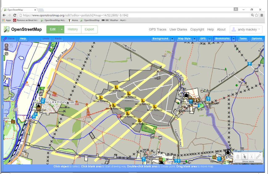
https://www.openstreetmap.org/#map=15/52.2597/-0.1966
Some similar ideas here https://wiki.openstreetmap.org/wiki/Mapping_techniques
Andy, thats the old fashioned way of ordnance survey (OS) making cross references to pin point an object. Note; its strange to noticed a diversion in the design of the layout, you could ask the project manager to solve this question.
See something I wrote ages ago https://wiki.openstreetmap.org/wiki/User:SK53/Mad_Ideas#Naive_Triangulation_from_Images
SK53 I liked the idea and did try it out. The results did not seem to be so accurate, not sure where i went wrong. But another useful technique is to create straight lines between a turbine and some other object ( such as a tree or power pylon that is on bing and then repeat from another direction to pinpoint a turbines position.
I looked at Digital Globe and found the Turbines are visible now, I moved some up to 30 meters to position them more accurately but i was fairly pleased with my first attempt.
Digital Globe seems to show the first stages of construction for another turbine group. At least for 3 of the 4 turbines here, One is 30 meters off and two are close if the circular blobs are the bases under construction. https://www.openstreetmap.org/#map=17/52.34308/-0.29632
Thanks! Lots of useful comments here :)